Misehkow & Albany Rivers Summary
Ontario, Canada
July 10 – 20, 1991
By Mel Baughman, Hayward, Wisconsin
For a complete journal with more details, contact the author—baughman@umn.edu.
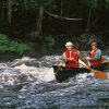
Crew: Mel Baughman and Guy Mueller
Route:
On July 10 we drove from Minneapolis/St. Paul, MN in 13 hours: 15 minutes to Pickle Lake, Ontario, and then spent the night in a motel. The next morning we flew in a Beaver for 30 minutes to a wide spot on the Misehkow River one mile downstream from Iron Falls. The pilot put is ashore on a point of land jutting into the lake. From there we took four days to paddle about 40 miles down to the Albany River. Then we spent another four days paddling about 40 miles on the Albany to Howells Lake, just upstream from Miminiska Lake. The next day a float plane picked us up on Howells Lake for a 50-minute flight back to Pickle Lake. We started driving home the same day and spent the night in a motel near Raith, Ontario, then arrived home on July 20.
River Conditions:
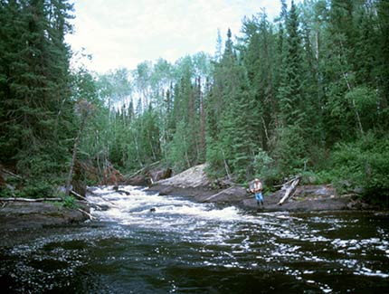
After loading our canoe Guy and I paddled upstream to the base of Iron Falls and hiked upstream to fish. The Falls is a long cascade extending over a quarter mile. It was quite pretty as the narrow river plunged over rock ledges. Then we continued downstream. For the first 16 miles and two days of paddling the river averaged about 50 yards wide and moved slowly between clay banks. There were so few features on the river to compare to our topographic map that we were uncertain exactly where our campsites were located. There was only one rapid occurring toward the end of that stretch which we scouted thoroughly and ran with no problems. Over the next 6 or 8 miles we encountered three rapids that we scouted thoroughly and ran without incident, then late in the day we camped at a fourth rapid with a three-foot high ledge. After unloading gear we lined our empty canoe over the ledge. On our fourth and final day on the Misehkow we covered about eight miles, running about eight rapids and as many little riffles. We portaged around two rapids and lined over one.
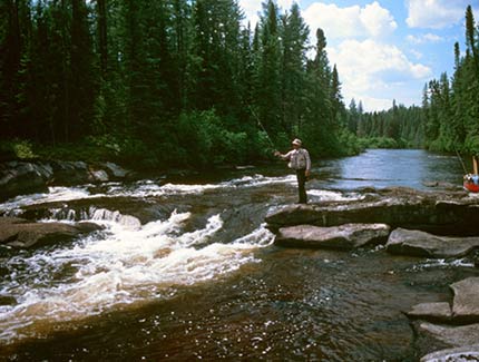
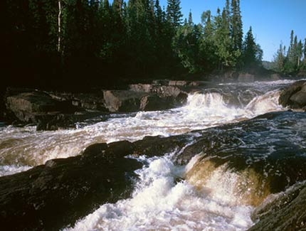
One-half mile down the Albany River there was an easy rapid. Then we paddled another nine miles and camped at a second rapid. The Albany averaged 100 – 150 yards wide. The next day we paddled another nine miles through numerous riffles where the river braided through islands and over shoals to a marked rapid where we camped. During our third day on the Albany, we paddled 7 miles plus at least three miles up Patte lake to the Shabuskwia River, then back down to the Albany. At Upper Eskakwa Falls we portaged about 60 rods on the right bank over a well-worn, level trail. The river divided into channels around an island. Each channel had its own waterfalls. It was a beautiful area. At Eskakwa Falls the river is channeled through a 30-foot-wide slot and churned to a froth. We portaged around this falls on the left bank and set up camp near the end of the portage. It took about four minutes to walk each way on the portage. The next morning we came to Snake Falls which is really just a long, steep rapids. It looks runnable, although there are some big standing waves. To be safe we portaged on the left bank. This trip also took about four minutes each way. Below Snake Falls there was no perceptible current in the Albany River all the way to Howells Lake. We paddled about 1.5 miles up Howells Lake and camped on a rock outcrop. The next morning we paddled to a sandy beach at the southeast corner of Howells Lake for our float plane pickup. Because of shallow water, the plane could not reach shore, so we had an offshore water pickup.
Campsites:
Sites were difficult to find. We had a mixture of both previously used sites and virgin sites that we cleared ourselves. None of the sites offered much open space. Take a saw and ax.
Topography:
There were small hills on the Misehkow, but land along the Albany was relatively flat, especially below Snake Falls and around Howells Lake. This was a Canadian Shield landscape similar to the Boundary Waters Canoe Area, but the upper Misehkow had mostly clay banks and no rock outcrops. We found fairly frequent rock outcrops on the lower half of the Misehkow and along the Albany. Around Howells Lake there were both sandy beaches and rock outcrops.
Vegetation:
The forest was mostly spruce and jack pine mixed with some aspen. We saw large areas of blowdown, especially around Iron Falls on the Misehkow. Vegetation was so dense that we could not travel inland.
Insects, Fish & Wildlife:
Insects: Mosquitos and blackflies were a nuisance, especially in our brush campsites.
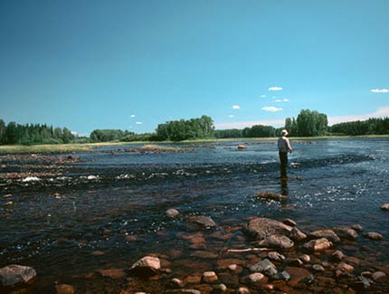
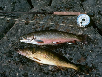
Fish: We chose to canoe the Misehkow because of its reportedly good brook trout fishing, but we caught few brookies. At Iron Falls I caught only 1 small brookie and four small walleyes. The last 10 miles of the Misehkow had nearly all of the rapids and we caught some brookies up to 17” as well as walleyes around them. We caught a few small northern pike around weed beds, fallen trees, and rapids. By the time we had reached the lower Misehkow we were discouraged by the fishing and did not even fish many of the rapids. That probably was a mistake. If others want to fish the Misehkow, note that we later heard the best brook trout fishing is above Iron Falls. To catch fish below Iron Falls, paddle quickly for about 20 miles and concentrate on rapids over the last 20 miles above the Albany. We were very happy with fishing on the Albany. In the braided stretches just below the Misehkow and around the three falls we had good fishing for walleyes and northern pike. We also caught walleyes and/or pike in Snowdrift, Patte, and Howells Lake.
Wildlife: Eagles, osprey, moose, black bear.
Canoe & Equipment: We paddled an Old Town Discovery 174 with lining ropes, but without a spray skirt. We were glad that we had just two people and one small tent to set up in the small campsites.
Topographic Map 1:250,000: 52P Miminiska Lake
Flight Service: Peter Johnson, Pickle Lake Outposts, P.O. Box 220, Pickle Lake, Ontario P0V 3A0, Canada; johnsonpl@yahoo.com, toll free 1-800-461-2547, www.fishpicklelake.com