Pigeon River
TRIP LOG: Submitted by Mel Baughman, May 2015
Ontario, Canada
July 27 – August 4, 2002
By Mel Baughman, Hayward, Wisconsin
For a complete journal with more details, contact the author—baughman@umn.edu.
Crew: Mel Baughman, Dan Godwin, Ruth and Tom Moore, Guy Mueller, and John Quaife
Route:
We drove for 12 hours from the Twin Cities to Matheson Island on the western shore of Lake Winnipeg. A short ride on the car ferry transported us to the island. There we stayed overnight at the Lake Winnipeg Eco Inn and on the following morning drove to the Wamair float plane base a mile away. A single-engine Otter made two 30-minute flights one-way to deliver our party to the put-in on Amphibian Lake, 86.5 miles upstream from Lake Winnipeg. In retrospect we wished that we had begun a few miles further upstream at Family Lake in order to see Shining Falls, one of the highest in Manitoba. While planning the trip we eliminated that upper stretch to insure we could paddle to our destination in seven days. On our last night of the trip, we camped five miles from the river mouth to avoid entering the Indian Reservation and low, swampy terrain near the river mouth. On Sunday morning we awoke at 5:00 a.m., loaded canoes, and paddled to a perfect sand beach at the mouth of the river where an Otter and Beaver float planes arrived to fly us back to Matheson Island.
River Conditions:
The Pigeon was three feet above normal. The stems of shoreline shrubs were under water at Amphibian Lake. This high water washed out some small rapids, but intensified the waves at many other rapids. The river was tannin-stained providing 15 inches of visibility.
The Pigeon River is described in various publications as Manitoba’s premier white-water river. It drops 277 feet in 92 miles from Family Lake to Lake Winnipeg and pours through about four dozen rapids. My count of rapids differs from those shown on the topographic maps. Some rapids, including a 10-foot waterfall that we encountered were not shown on the topographic maps and some rapids on the topographic maps did not actually occur on the river. If the topo map showed a very narrow constriction in the river, we learned there likely would be a rapid, whether it showed on the topo map or not.
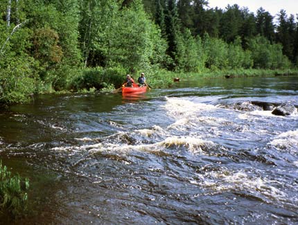
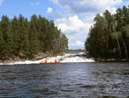
The Pigeon was a pool-and-drop river with rapids occurring at bedrock ledges where the river often dropped 5 to 15 feet. Rapids were short, usually single ledges or cascades over broken rocks followed by long trains of big standing waves. Very strong, potentially hazardous, boils and whirlpools often continued downstream from the ledges for several hundred yards. Flat water prevailed between rapids.
We usually could paddle flat water to a vantage point above a rapid where we stood in the canoe to assess the rapid. Occasionally a rapid was long enough to require bank scouting. After a quick look, we determined whether to run, line, lift over, or portage a rapid. Each canoe made its own decision, but typically we all agreed on how to negotiate each rapid. There were so many rapids that at the end of each day we could not remember exactly which ones we ran, lined, lifted over, and portaged. We did not run many rapids because of the violent waves and steep drops. A few more would be runnable at a lower water level. We lined a few short rapids, but the ledges were usually too steep for safe lining. We often paddled up to the edge of a ledge and found that we could slide our canoes over a short section of bedrock or perform a six-person liftover with fully loaded canoes. We fully unloaded gear and portaged about 15 to 20 rapids.
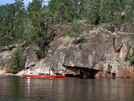
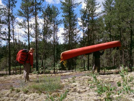
The entrance to most portages could be identified only by a muddy, usually steep bank, somewhat wider than a beaver slide, and a small opening into the shoreline tree cover. When the portage entrance was not obvious, we deployed a scouting crew on each bank. In just a few minutes one crew or the other would find the portage trail. Nearly all portages could be walked in 2-5 minutes but the “gorge” at mile 55 required portaging about ½ miles over a good trail.
The Pigeon’s bedrock ledges were quite picturesque and generally much more dramatic than those on the nearby Bloodvein River which several of us had canoed previously. The Bloodvein, however, had many more cliffs. We had canoed both the Pigeon and Bloodvein in high water, but the Pigeon appeared to carry nearly twice as much volume as the Bloodvein.
Our schedule required that we paddle 12.4 miles per day and we had no difficulty covering this distance despite frequent stops for fishing. We typically paddled 11 miles and then looked for a campsite. We nearly always found a campsite within one mile after beginning our search, although we soon learned to read topographic maps to get a sense of whether a campsite was likely to occur on a particular stretch of river. We found good campsites by looking for large granite outcroppings with flat tops. Low swampy terrain along the river had fewer campsites, but topo maps showed us where high ground would occur. We favored sites at rapids, expecting better walleye fishing there, but sometimes took sites on flat-water stretches if there was no rapid near the point where we ended our 12-mile paddle or if there was no campsite at the preferred rapid. Tent sites often were on bedrock, usually with a thick covering of moss and lichens, requiring us to use rocks instead of stakes to hold down our tents.
Vegetation:
Typical boreal forest bordered the river. Jack pines predominated, especially on the upper river and on ridges. White spruce, black spruce, balsam fir, and balsam poplar were abundant in lowlands. Trembling aspen and white birch were scattered throughout, but were more common on the lower river where they regenerated after timber harvests and beaver cutting.
Insects, Fish & Wildlife:
Mosquitos were ravenous after dark and during the first hour of daylight, but during the day and evening, they seldom bothered us.
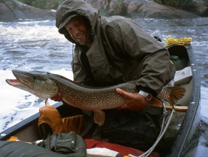
We did a lot of fishing, but not much catching. Although gorgeous weedbeds lined the banks along much of the river, we caught very few northern pike and walleyes were scarce below rapids. The unusually high water created strong currents in the vicinity of rapids and we think this displaced walleyes from their typical haunts. We caught a few channel catfish in the lower 30 miles of the river. Although we caught enough fish all along the river to meet our needs for fried fish and fish chowder, our best fishing occurred in the eddies below Sturgeon Falls at mile 14 1/2.
The dense forest made wildlife difficult to spot. We saw several otters and beavers, one black bear, a few red squirrels, numerous bald eagles, a couple of ospreys, crows, ravens, ducks, loons, nighthawks, and a few shore birds.
Canoes & Equipment:
We paddled two Old Town Discovery 174s and a 17-foot Penobscot without spray skirts. No one on our trip swamped a canoe and we bailed a little water on only a very few rapids. We passed a youth group of high school students, however, and all of them had swamped canoes along the river. A combination of bent-shaft paddles for flat-water and straight-shaft paddles for white-water worked well on this river.
Topographic Maps 1:50,000: From canadamapsales.com. 52M/13 Viking Lake, 62P/16 Magnusson Lake, 63A/2 Catfish Lake, 63A/1 Short Lake.
Lodging at Matheson Island: Lake Winnipeg Island Eco Inn, Matheson Island MB, R0C 2A0. (204) 276-2121
Float Plane Service: Wamair Service and Outfitting, General Delivery, Matheson Island, Manitoba R0C 2A0; Canada; 204 276-2330
