Gull River Summary
TRIP LOG: Submitted by Mel Baughman, May 2015
Ontario, Canada
June 26 – July 2, 1999
By Mel Baughman, Hayward, Wisconsin
For a complete journal with more details, contact the author—baughman@umn.edu.
Crew: Mel Baughman, Judy Geck, Ruth Moore, Tom Moore, Guy Mueller, John Quaife
Route:
In 11 hours six of us drove from the Twin Cities in Minnesota to our put-in on Highway 811 where it crosses the Moosehead River west of Lake Nipigon. Along the route we picked up a car shuttle driver from a local business. We camped at the put-in and the shuttle driver departed to deliver our vehicle to the take-out. From that first campsite we paddled 51 miles downstream on the Moosehead and Gull Rivers to the Highway 527 crossing over a period of five days. This was supposed to be a longer trip, but I developed an internal infection starting the fourth day of the trip so we paddled hard to get off the river two days early.
River Conditions:
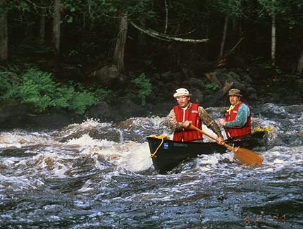
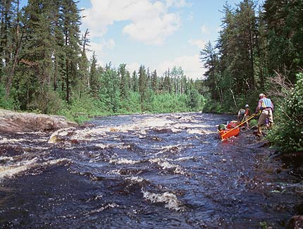
This was the most arduous 5-day canoe trip I ever completed. The river dropped 40 feet per mile in the first 6 miles. Over the next 35 miles the drop per mile ranged from 5.5 to 9.5 feet. The last 10 miles were nearly flat with little discernible current. Rapids were very long. Among the river’s 24 rapids, at least eight ran for over 1/4 mile, including four over 1/2 mile.
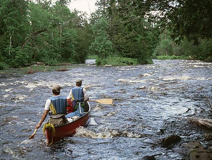
Unusually heavy summer rain had raised the water level to bank full. The high water covered most of the rocks in rapids, but created standing waves and washed out the eddies. The lower one foot of tree stems and shrubs were covered by water. In the upper river, the steep drop per mile coupled with high water created long trains of standing waves and few eddies in which to stop for scouting. We ran rapids cautiously, trying to stay out of the wave train.
Lining was difficult. It usually required gripping the canoe gunnels while stumbling over slippery, rounded boulders in waist deep water adjacent to big standing waves.
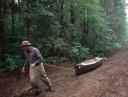
We took portages when available, but most portage trails had long ago grown over or were buried by fallen trees from windstorms and fires. I think we portaged seven rapids, but rapid #2 had the toughest portage I ever stumbled over because of fallen trees and dense brush. My partner, Guy, portaged our canoe over the toughest trails. He found that dragging it was easier than carrying it on his shoulders. If we did not find a useable portage trail, we knew the river had to be negotiated.
In my opinion this river should be canoed only by people in good physical condition with considerable whitewater experience. It was more than an adventure, it was a challenge. Based on the condition of portages and lack of campsites, this river does not appear to get much canoe traffic. We saw no other people on the river. I’m really glad that we took saws and axes to cut brush around campsites and on portage trails.
Day 1.
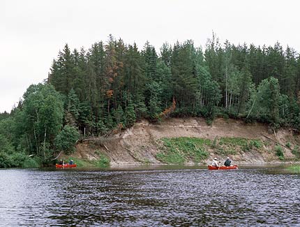
At the put-in we portaged equipment 450 yards around a rapid, but paddled empty canoes through it. The portage was fairly rough with several fallen trees. After this first portage, we had three miles of easy, flat-water paddling to rapid #2. It took us about three hours to finish this 1100 yard portage and we paddled the final 200 yards of the rapid. I think this was the roughest portage I’ve ever done because of fallen trees and thick brush. We were able to run rapids #3 (500 yards) and #4 (350 yards), and then camped at the head of rapid #5 after paddling only about four miles. The river averaged 25 to 40 feet wide in rapids, but 100 feet wide in flat-water stretches.
Day 2.
From camp we portaged around rapid #5 (950 yards), then paddled a half mile to rapid #6 (no yardage given). A portage was indicated on our map, but we found only a faint trail. Tom and I scouted a quarter mile downstream and recommended we not canoe or line the river. Guy headed across the portage with a pack while the rest of us used two saws and an ax to clear about 200 yards of trail. Then we came to a large area of blown down trees and could not find the trail at all. We gave up clearing and decided we had to negotiate the river. The Moores and John and Judy started lining their canoes down river. I walked up the hill and shouted for Guy who had been gone for two hours. Guy answered back and soon was at the landing. Although he had dropped his pack at the base of the rapid, he fortunately brought back his life jacket and canoe paddles after deciding for himself that we could never walk the portage route. We followed the others downriver. It took us at least an hour to line and briefly paddle a couple of short stretches, but we made it. We were wet to our waists. Downstream 1/2 mile we portaged rapid #7. Fortunately the trail was clear and we did it easily. The Ministry of Natural Resources map said this portage was 1200 yards, but that distance is not correct. It was more like 600 yards. The portage trail re-entered the river above the last short rapid in this series which is located at a hair-pin curve bending south. We lined this short rapid at about mile 43 3/4 and ran rapid #8 in pieces. I spotted a rare rock outcrop at mile 43 1/4, just upstream from rapid #9 (300 yards), and we used it as a campsite, although it was imbedded in a dense stand of black spruce and balsam fir. We paddled three miles today.
Day 3.
We ran rapid #9 (300 yards) and #10 (100 yards), but portaged rapid #11 (300 yards) over an easy, clear trail. We lined rapid #12 (300 yards) along the right shore. It was a long rapid (longer than the portage distance indicates). We camped in a moose hunter’s site on a point of land on the west side of the Gull, about 300 yards north of the Roaring River’s mouth. We had paddled about 7 miles.
Day 4.
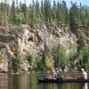
The river had picked up a lot of volume since the Gull River and Roaring Rivers entered yesterday. The average width spread to about 150 feet and standing waves in the rapids were higher than on Day 1. We put in a grueling day of paddling and lining, covering a little over 19 miles. I wrote this day’s journal entry three days after the trip ended so I don’t recall all of the details about the 10 rapids we negotiated. I believe we ran or lined rapids #13-20 and 22. We ran the upper half of #21, but portaged about 100 yards on the lower end over a good trail. We lined several long rapids but also had some great paddling runs. From mile 33-27 the river flowed past 400-foot high hills and there were several high cut banks and cliffs to provide interesting scenery. From mile 27-23 the river corkscrewed through a lowland.
Day 5.
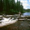
Our first challenge was the long rapid (#23, 1 1/2 miles) near Detour Lake. For 10 minutes we discussed whether to negotiate the river by paddling and lining most of it and portaging around the waterfall or to take the reported 2-mile portage. Because the water level was so high and we knew little about the river obstacles, we chose the portage. I also favored the portage because I didn’t want to get chilled again, like yesterday, while fighting an infection. The portage turned out to be a wise decision although it took us 2 1/2 hours to complete. We had about 200 yards of forest path at each end of the portage, but the middle section was on a logging road with a packed sand base. It was an easy walk. I estimated the portage distance to be about 1 1/2 miles, not 2 miles as marked on MNR maps. I walked from one end to the other in 35 minutes. This logging road was abandoned at the upstream end, but it had been recently graded and showed more use at the downstream end. The final 200′ of trail at the put-in was down a very steep grade, probably a 45% slope. We used ropes to hold the canoes back. We each took a short walk down a side trail to see the waterfall in this stretch of rapid. It was at least a 10-foot drop and quite scenic. I noticed that there was a long stretch of big standing waves below the waterfall that we might have had to negotiate if we had decided to paddle the river rather than portage it all. Rapid #24 (250 yards), the last on the river, was runnable. The final ten miles snaked through a lowland and the river lost nearly all of its current. Several oxbow lakes connected to the main channel. We covered 17 miles this day.
Vegetation:
On the upper river, alders lined the river bank and were backed up by black spruce, balsam fir, jack pine, and birch. Spruce and fir were especially common on the flat landscape. On the lower river aspen and birch were the most common species, but there were a few elms and bur oaks too.
Insects, Fishing and Wildlife:
Mosquitoes, blackflies, and no-see-ums took turns feasting on us. Bugs were bad! Headnets were a necessity!
Fishing was only fair for walleyes and northern pike, although the high water may have dispersed fish more than usual for this time of year. Hey, every angler can find an excuse! We caught walleyes up to 20 inches and northern pike up to 10 pounds, although most pike were hammer handles. We cast small spinners, spoons, and jigs hoping to catch brook trout, but did not find any.
We saw a few otters and one moose.
Campsites:
Campsites were very scarce although we found suitable sites each night. We sometimes had to use a saw and ax to clear brush for a campsite.
Canoes and Equipment: We used two Old Town Discovery 174s and one Old Town Penobscot. We paddled straight-shaft paddles in white-water and bent-shaft paddles in flat-water. We pitched a 12’ x 12’ rainfly in some campsites when rain was a nuisance. We did not have a bug tent although it would have been useful in those sites that were large enough to accommodate it.
Topographic Maps 1:50,000: 52H/11, 52H/12, 52H/14