Steel River
Ontario, Canada
September 18 – 25, 1999
By Mel Baughman, Hayward, Wisconsin
For a complete journal with more details, contact the author—baughman@umn.edu.
Crew: Mel Baughman, Mike Baughman, Phil Ashcraft, and Roger Forney
Route:
Roger and I drove 11 ½ hours from Minneapolis/St. Paul to Marathon, Ontario on the North Shore of Lake Superior. Beyond Grand Portage and all across the North Shore, we enjoyed majestic scenery with high, forested hills garnished with fall color and vistas of islands in Lake Superior. We met Mike and Roger at the Peninsula Inn in Marathon, then packed our personal and group gear. The next day we drove west on Highway 17, then north on Dead Horse Road to the beginning of a portage trail to Steel Lake.
Directions to Put-In and Take-Out: The Steel River is east of Lake Nipigon and flows southward into the North Shore of Lake Superior.
From the west: From the Esso Gas station in Terrace Bay, Ontario, drive 23.5 miles east on Highway 17 to Dead Horse Road and turn north. This road is just past the Dead Horse Creek bridge on Highway 17.
From the east: From the Peninsula Inn on Highway 17 about 2 miles west of Marathon, Ontario, drive west 18.7 miles to Dead Horse Road and turn north. Or from the Little Pic River bridge on Highway 17, drive 3.2 miles west to the Dead Horse Road.
After turning north on Dead Horse Road: continue north and west for 23.2 miles to the Steel River Bridge (take-out point). The Dead Horse Road is a good, but winding gravel road that can be driven at 20-40 mph. The drive takes about 45 minutes. There are several side roads that turn off, but stay with the main gravel road. Leave a car at the Steel River Bridge for the take-out. To get to the put-in, continue west from the Steel River Bridge for 0.5 miles to a T-intersection; turn north (right); and continue 4.3 miles to a gravel road on the left that goes up a steep hill. This side road is at road marker 47 km. Turn left (west) up this poor gravel road for 0.4 miles to where it curves sharply to the right. Park at the curve; do not continue onward to the end of the road. Two different portage trails head northwest through the edge of a clearcut. We portaged packs on a narrow, but good trail over a small hill, through a spruce stand, and across a creek on a rickety foot bridge for about one-half mile to Steel Lake. It took 11 minutes to walk this trail one way without gear. This “high” trail had too many tight turns through the first spruce stand to portage our canoes. We portaged our two canoes along the “low” portage trail. It was 300-400 yards from the car through a bog and around the edge of a beaver pond until that “low” trail joined the other “high” trail. This “low” trail was muddy but passable. I carried my canoe along this whole route except at the beaver pond. Phil sunk in the mud so badly that he dragged his canoe across the initial bog.
If you do not have a second vehicle to leave at the take-out, then you could stash a bicycle at the takeout or walk/jog five miles from the take-out to the put-in.
River Conditions:
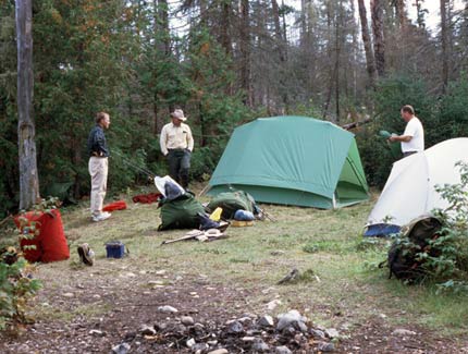
To begin our paddling adventure, we each took two round trips to portage gear and canoes one-half mile to Steel Lake. Several motor boats were stashed in a narrow cove where we put in. Over the next six days we paddled 45 miles, averaging 7 ½ miles per day, allowing plenty of time for fishing.
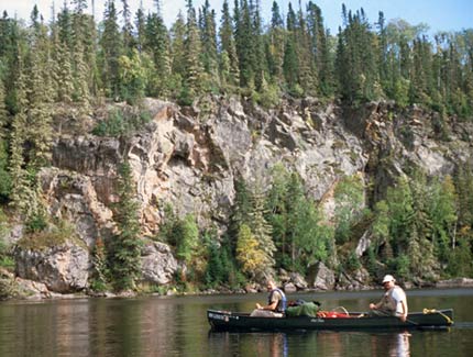
Steel Lake varied from 1/4 to ½ mile wide and was about 18 miles long, running south to north. It was a rather featureless lake with just a few islands. We spent two days on the lake, then four days on the river. The river was 50-75 feet wide in narrow sections, but there were several wider, lake-like sections. River-like stretches were scenic with occasional cliffs and overhanging cedars.
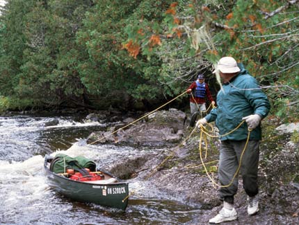
The Steel River began with a rapid. Our Ministry of Natural Resources map showed a 234 yard portage, but we lined and ran this first rapid. Then we paddled through a small lake and portaged 509 yards around another long rapid. It was a fairly rough portage through a burned forest with fallen trees. After that tough portage, we paddled another short stretch and portaged an easy 139 yards. Our ax and two saws were useful on both portages to clear fallen trees and branches protruding onto the brushy trail. Just after finishing the third portage, we paddled around the corner and found a well-cleared, grassy, flat campsite at mile 25 ½ along a narrow, lake-like section.
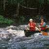
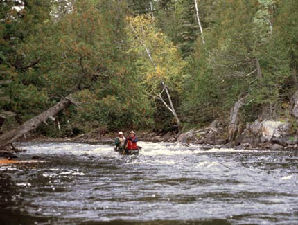
The second day on the river we especially enjoyed paddling three miles of fast current with frequent Class II rapids. We lined short stretches of two rapids, but ran the rest. At the end of the day we found a very nice campsite in a cedar grove at mile 17.
During the third day on the river, we paddled numerous small lakes separated by short rapids. We lined part of a rapid near mile 13 ½. At mile 9 ½ we found a very nice campsite in a jack pine stand on a lake. A table fashioned by previous campers from plywood and logs was handy for our kitchen.
On our fourth and final day on the Steel River, we paddled ½ mile down the lake on which we were camped, but the remainder of our 9-mile trip was on a flowing river. The river had a lively current with frequent, easy rapids. A waterfall at Mile 7 was very scenic. Its vertical, stair-step drop of 30-40 feet was followed by a cascade over boulders. The river may have dropped 70 feet total at this spot. There was a nice campsite along the portage trail. The 345-yard portage was relatively easy to walk. Below the waterfall, the river narrowed to 25-70 feet and continued at that width to the take-out bridge on Dead Horse Road. There was a steady current with frequent riffles. We could see the gravel bottom six feet below. Overhanging cedars created an interesting green corridor. Eroding sand banks toppled many trees into the river. Several trees blocked the river at one spot, but a convenient sandbar was available for a 4-person liftover. At the bridge we found our parked shuttle vehicle and drove five miles to my van at the put-in.
Campsites:
Campsites were scarce on Steel Lake. On the first night we used an ax and two saws to cut brush and fallen trees to create a campsite at mile 35.2. On the second night we camped at mile 30.5 in an existing site in a burned area, but found a patch of green northern white-cedars in which to hang a rain fly for protection over our cooking area. Campsites along the Steel River likewise were widely scattered, but we always found a nice, well-used site.
Weather:
Rain and sleet were nuisances for the first two days and light showers fell on a couple of other days. We also encountered strong winds on Steel Lake. On clear nights the temperature dropped as low as 25o F while daytime temperatures typically were in the 50s and 60s. Northern lights varying from a white fringe on the horizon to green, undulating curtains, were a treat to see on clear nights.
Vegetation:
The dense, northern forest was composed mainly of spruce, jack pine, aspen, and birch. At a burned over campsite near the north end of Steel Lake, we picked enough blueberries to enhance pancakes.
Insects, Fish & Wildlife:
Insects were not a problem on this late season trip.
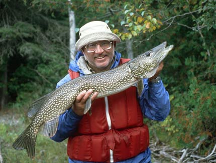
Where Roger caught a blue walleye (a.k.a. blue pike) while trolling on Steel Lake, we stopped to jig and caught several walleyes and a northern pike. The blue walleye is a subspecies of walleye that once occurred throughout much of southern Ontario as well as Lakes Erie and Ontario. It has been extirpated from the Great Lakes, but still occurs in a few Ontario lakes and rivers. We caught both species of walleye and many small northern pike on the Steel River. At the foot of each rapid we fished and caught enough walleyes for lunch.
I had an 18-inch walleye on a cord stringer hanging over the side of the canoe when a big northern pike tried to swallow my walleye. The pike thrashed around while I tried in vain to net it. When the pike finally let go of the now lacerated walleye, Mike and I threw our lures into the water and the pike struck my spoon. Mike paddled the canoe to shore where I landed the 38-inch, 14 pound pike on a gravel beach.
Wildlife: moose, otter, bald eagle, ruffed grouse.
Canoes & Equipment: We paddled an Old Town 174 and an Old Town 169 with lining ropes, but without spray skirts.
Topographic Maps 1:50,000: Killala Lake 42 E/2, Spider Lake 42 E/7