Bloodvein River Trip Report
Trip Dates: June 24, 2014 to July 9, 2014
Nearest Cities: Red Lake, Ontario
Bissett, Manitoba
Nearest Village: Bloodvein, Manitoba
Put in: Knox Lake, Woodland Caribou Provincial Park Take out: Bloodvein Village on Lake Winnipeg, Manitoba Water level: High
Canoes: Penobscot, Old Town (17 ft, Royalex, homemade spray skirt) Spirit II, Wenonah (17 ft, Royalex, homemade spray skirt)
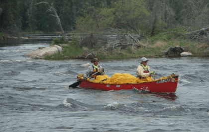
Paddlers: Jerry Storm, Cook, Minnesota
Kevin Groenveveld, Chanhassen, Minnesota
Jim Liechty, Winterset, Iowa
Vern Fish, Waterloo, Iowa
Difficulty: Experienced-novice to Intermediate – This trip requires wilderness camping skills and the ability to read and paddle whitewater from CI to CIII.
Submitted by: Vern Fish
Heritage River:
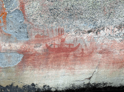
The Bloodvein River is part of the Canadian Heritage River System (CHRS). The CHRS was established in 1984 to conserve rivers with outstanding natural, cultural and recreational heritage, to give them national recognition, and to encourage the public to enjoy and appreciate them. Today, there are 42 Canadian Heritage Rivers across Canada. The Bloodvein River connected the prairies of western Canada to the woodlands of the east. As such it became a cultural highway that is steeped in native history. The Artery Lake pictographs are recognized as nationally significant. It also provides access to a series of outstanding whitewater features in a remote wilderness setting. We came to run the whitewater, catch fish and appreciate the cultural history of this special river.
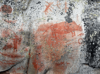
Pictographs from Woodland Caribou Provincial Park, Red Bison Panel at Artery Lake.
Pictographs from Woodland Caribou Provincial Park.
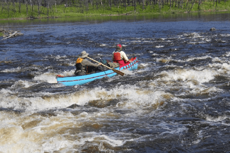
First whitewater run from Murdock into Larus Lake. Note the fire scar in the background.
Maps & References
Wilderness Rivers of Manitoba (ISPN 1-55046-440-X) by Hap Wilson and Stephanie Aykroyd provide a detailed description of this trip. All 89 whitewater features are described and drawn in detail. These meticulous notes allowed us to make wise decisions and allowed us to safely run or portage, as we deemed necessary. The notes and drawings were done almost 20 years ago but we found them to still be incredibly accurate. In addition to the precise drawings, the authors also offer different options for each run. I had only one criticism of this book. Because a huge amount of detail had to be packed into a limited number of pages, it was difficult to track the order and location of the whitewater features. We tried to solve this problem by cutting & pasting the drawings onto a large-scale map. This was hard to do because of the sheer number of rapids. Along one stretch of this river you will face 12 runs within 7 kilometers! After using this book, it is obvious that Hap and Stephanie deserved to be called expert paddlers!
The Adventure Map for Woodland Caribou Provincial Park is an excellent route map and should be used with the Wilderness Rivers of Manitoba while paddling the headwaters in Ontario. Hap’s book provides the location of campsites and pictographs that are not shown on the park map. This map was produced by Chrismar Mapping Services at www.theadventuremap.com and is sold by Canoeing.com at www.shopcanoeing.com/products/
woodland-caribou-park-map.
The only route maps I could find for Atikaki Provincial Wilderness Park on the Manitoba side were so general that they were really not of any help.
I ordered the following 1:50,000 maps* from Map Town out of Calgary, Alberta at www.maptown.com:
62P08 Shallow Lake
52M12 Sasaginnigak Lake
52M05 North Eagle Lake
52MO6 Artery Lake
52MO7 Sabourin Lake
52MO2 Murdock Lake
52MO1 Pipestone Lake
62P15 Princess Harbour
62P10 Pine Dock
62P09 Minago Creek
*Some of these maps only show a corner or short run of the Bloodvein River. One stretch of the river flows back and forth over at least three maps which will force you to be very creative if you try to “cut & paste” the maps. These map overlaps also make it very hard to incorporate Hap’s detailed drawings for each rapid.
In some cases I went directly to The Atlas of Canada – Toporama at http://atlas.nrcan.gc.ca/site/english/toporama/index.html and printed the segment of the river where the map details were lost due to map overlaps. I cut & pasted Hap’s detailed drawings onto these maps so that the bowman would have a more detailed picture of what was just downstream. I have attached a sample of one of these maps.
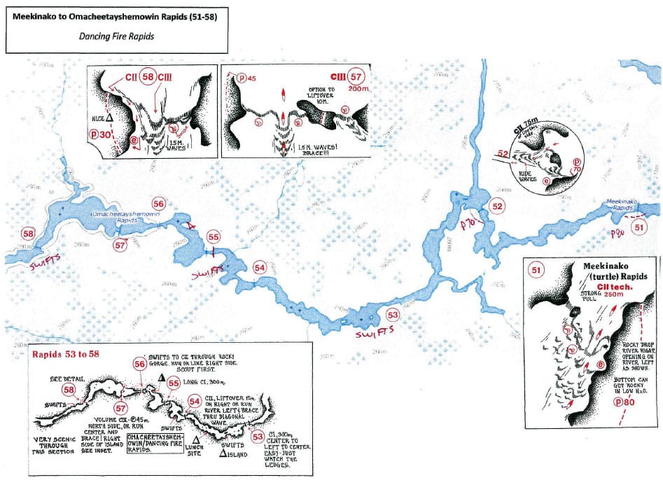
Example of a map printed from the Atlas of Canada with drawings by Hap Wilson cut and pasted to give more details on the whitewater features.
I would recommend that you find a copy of the Canoe Atlas of the Little North by Jonathan Berger and Thomas Terry (ISBN 978-1-55046-496-2) for reference. This oversized book provides a cultural and natural history of northern Ontario and eastern Manitoba and offers a deeper understanding of the historic canoe routes of this region.
Finally, a few hundred paddlers run this river each year. Many of these paddlers are now posting video logs of their trip. It is pretty easy to go online and find the most current posting.
Permits & Fees
There is an Interior Camping Fee for camping in Woodland Caribou Provincial Park. The cost is per person per night and is higher for non-residents of Canada. In 2014 the cost was $13.25 (Canadian $ before taxes) for non-residences who were 18 years and over. I purchased our permits from the park office in Red Lake, Ontario by mail. The staff was very willing to answer questions and also provided updates on the condition of portages and the current fire status. This office can be reached by phone at 807-727-1329. I bought four nights worth of permits for our paddle across WCPP.
If there was a fee for entering Atikaki Provincial Wilderness Park, I could not figure out how or where to make the payment. I am pretty sure there is not a cost. We already had Ontario fishing licenses so we bought a Manitoba fishing license from Blue Water Aviation in Bissett before we flew out.
Logistics
The headwaters of the Bloodvein River are located in the northeast corner of Woodland Caribou Provincial Park (WCPP). WCPP is located in western Ontario on the border with Manitoba. Red Lake is the gateway city to this park. We chose to drive to Bissett, Manitoba and flew into Knox Lake in WCPP rather than drive to Red Lake, Ontario and portage in from Lund Lake or Pipestone Bay on Red Lake.
We stayed at the Northern Wings B&B in Bissett. The hosts are Barry & Lek Ecklund at 204-277-5215. Their email is nwings@xplornet.ca. Blue Water Aviation provided the flight into Knox Lake. Their contact information is www.bluewateraviation.ca. Bissett is a gold mining town with very few services. Do not plan to do any last minute shopping for things you forgotten.
We arranged to have our vehicle brought up from Bissett by Blue Water Aviation and left at the construction site of the new bridge being built over the Bloodvein River. This bridge now provides year round access to Bloodvein Village. Previously, paddlers would have taken the ferry across Lake Winnipeg to get a hard surface road to go south. In 2015 paddlers will have the option of leaving their vehicles in Bloodvein. We could have stayed in a lodge in Bloodvein Village but we chose to leave the same day we arrived. Working with the village office we were able to find drivers and two trucks to transport us and our gear a short distance up the new road to the new bridge. We proceeded to load the canoes and paddle under the bridge for the second time and across the river to our vehicle.
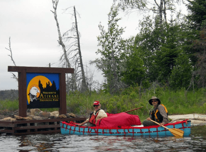
Jerry and Kevin crossing into Manitoba and entering the Atikaki Wilderness Provincial Park.
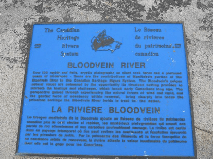
The Canadian Heritage River plaque is located at the bottom of the next rapids.
Trip Overview
This trip can be broken into two major segments: headwaters and downriver. The headwaters segment of the trip is about 45 miles and can be characterized as a series of medium to large lakes connected by small streams interrupted with rapids or waterfalls. We paddled across northern Woodland Caribou Provincial Park from Knox Lake through Murdock Lake, Larus Lake, Lawrence Lake, Barclay Lake, Mary’s Lake and finally into Artery Lake. There are other places to start this trip. We ran into a party of young men who started their trip much further upstream and had paddled down the Dutch and Sabourin River to enter the Bloodvein River at Lawrence Lake. There are outpost cabins within the park and we did see motorboats.
When you portage into Lower Artery Lake, you cross the Manitoba border and enter Atikaki Provincial Wilderness Park. This is the beginning of your 135-mile run down to Lake Winnipeg. This stretch of the trip is classic “pool and riffle” and is characterized by shallow lakes or long narrow stretches of “dead or slack water” separated by rapids or falls. The vast majority of the whitewater features are located downstream from Artery Lake. There are a few active outpost cabins and a couple of “abandoned” cabins along this segment but we did not see any motorboats. The Bennet Trappers Cabin that is just downstream from the confluence with the Gammon River was one of the highlights of the trip. It gave us a chance to sign the “Stagger Inn Journal”.
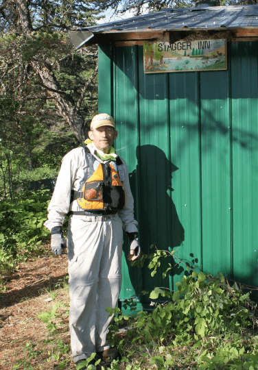
The Stagger Inn Cabin just downstream from the Red Rock Cafe, campsite at the junction of the Gammon and Bloodvein River.
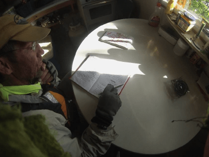
Jim signing the journal at the Stagger Inn Cabin.
The Bloodvein River is well known for its pictographs. I have attached a photo of the famous Red Bison panel on Artery Lake. Hap’s book does an excellent job of marking these cultural features. However, several of these panels are off the direct route and require back paddling to see them all. Even with Hap’s detail maps, we could not find the panel at Kautunigan Lake.
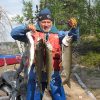
We were much more successful at catching walleye for supper in WCPP then when we were in Atikaki Provincial Wilderness Park. We know how to fish in big lakes but we were less skilled at catching fish in moving water. We also found that the walleyes we were catching in the river were smaller. We threw these small fish back thinking there were bigger fish to keep. The reality was these small walleye are the norm in moving water.
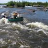
The 89 whitewater features were the highlight of the trip. It did not take long to realize that the water level was high which required us to adjust our thinking. For example, Hap describes a CIII at the bottom of Stonehouse Rapids as a “play rapids”. We found it both impressive and beyond our abilities because of the high water volume. Most of the portages were in pretty good shape and fairly easy to find.
Highlights
The place names attributed to this river give a paddler a sense adventure: The Cauldren, Bruiseasy Falls, Nutcracker Falls, Moosebone Rapids, X-Rock, Goose Rapids, Round the Bend, Island Rapids, Turtle Rapids, Hanging Rock, Split Rock, Crater Rapids, Red Rock Café, Shangra-La, Drumming Sound, Chap Falls, Skunk Falls, Water that Circles, Junction Jag, The Unknown Channel, Canyon Rapids, Golden Eagle Rapids, Unloading Rapids, Ankuasi Falls, Namay Falls, Eagle Nest Falls, Four Battle Rapids, Sharp Rock Rapids, and my favorite, Dancing Fire Rapids.
The following places captured the spirit of the Bloodvein for me. The entire river is forced into a narrow gorge that has been cut through solid rock at Stonehouse Rapids. Standing beside this spectacle of falling water, you can see hear and feel the roar of falling water. As the water surges down this narrow cut it creates a low rumble that varies as the volume ebbs and surges. This rumble was amplified by a dangerously close lighting strike later that night. For several minutes I laid in my little solo tent thinking that I might be the only survivor. That moment, captured for me, the true isolation and remoteness of this wilderness river.
“The Wall” was a delightful series of three CIIs on the north side of an unnamed island just downstream from the Red Rock Café. They cannot be seen or scouted, one just has to have faith that Hap Wilson has properly mapped them. You drop into the current and almost immediately you are presented with a vertical wall on river left. Before you realize what is happening, the current is pushing you sideways and the canoe is now a few inches from this ancient, moss-covered stone. In the blink of an eye, you sweep by and immediately hit two more drops before the river spits you out into an eddy. This is one reason I run whitewater!
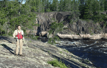
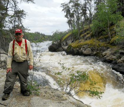
Vern on the bluff overlooking Manitou Rapids and the kettle holes above Akeeko Rapids.
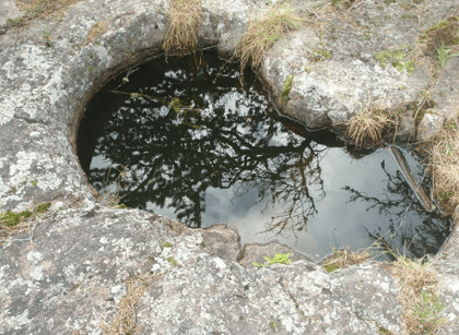
Kettle holes above Akeeko Rapids.
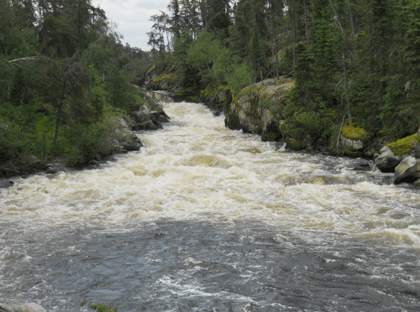
At Manitou Rapids the Bloodvein forces itself between two massive walls of rock to create a whitewater challenge for a paddler willing to run the risk. Jim and I had portaged down two vertical drops to position us downstream from the rapids. We tried to hold our position in an eddy while we waited for Kevin and Jerry to run this impressive surge of water. They hit the line perfectly and blew right down the channel. I was very concerned for their safety but their technique was flawless! The Bloodvein River gives a paddler a chance to test their skills.
Finally, the last major run of the trip was # 87 Meekisiwi Rapids, a CII tech at normal water levels. When we arrived it was an impressive standing wave. Jerry and Kevin went first and provided a pretty good example of what it looks like to be caught in a big haystack. They bobbed and rocked like a teeter-totter on an elementary school playground. They finally caught enough water to pull over and down the wave and out to flat water. I looked at Jim and he said “Gear up, let’s go.” We hit the V and hung for a couple of nano-seconds just like Kevin and Jerry. I can still feel the sense of weightlessness as we hung in the roaring white foam before the wave let us go. At this point every camera battery was dead. No pictures, just a great memory to close out the trip!
Jerry at the top of “The Gorge” at Stonehouse Rapids.
The bottom of “The Gorge”.
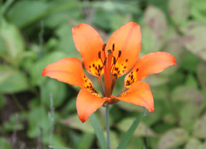
A Wood Lily in full bloom on the portage at Stonehouse Rapids.
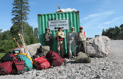
The take out point on the construction site of the new bridge across the Bloodvein River.