Bigstone and Fox Rivers Summary
June 19 – July 5, 2008By Mel Baughman, Hayward, Wisconsin
For a complete journal with more details, contact the author—baughman@umn.edu
Crew: Mel Baughman, Dan Godwin, Duane Lee, Doug Smith
Route:
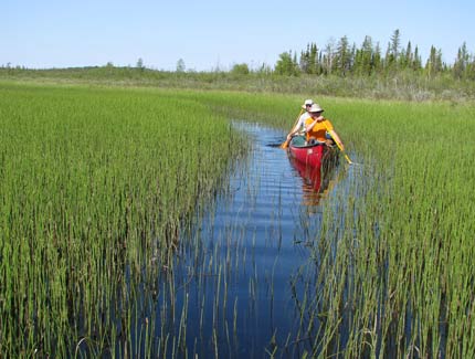
It took a good share of two days to drive from St. Paul, MN to Cross Lake, east of Wabowden, in northern Manitoba. At Cross Lake, a Cree community of 7,000 people, we hired a local Cree with his 16.5-foot motorboat to transport all our gear and people 45 miles to the end of Cross Lake. Duane located this man by calling a church in Cross Lake before our trip and asking the priest for assistance in locating someone with a suitable boat. The boat shuttle took two trips. Near the far end of Cross Lake at the mouth of Mistasinni Creek, we camped for the night before starting our 178 mile river trip. Our trip began by paddling a few miles upstream on Mistasinni Creek, then portaging one mile to the Big Stone River drainage. We traveled down the Bigstone River to the Fox and continued on it until ending our trip just above Rainbow Falls. A Beaver on floats flew us to Gillam in two trips. We had paid another Cree man to shuttle our car from Cross Lake to Gillam. Then we drove home.
River Conditions:
Mistasinni Creek was broad and shallow with little current so we made good time paddling upstream about 10 miles despite lifting over a few beaver dams. The tough part of our day was a one-mile, 3-hour trip over Pamechikamik Portage from upper Mistasinni Creek to the Big Stone River drainage. For the next two days we paddled flat-water, but also dragged over rocks and beaver dams and portaged once. We rose early to paddle all day through the expansive Bear Lake. The following day we encountered our first short stretches of current and some picturesque rocky ledges.
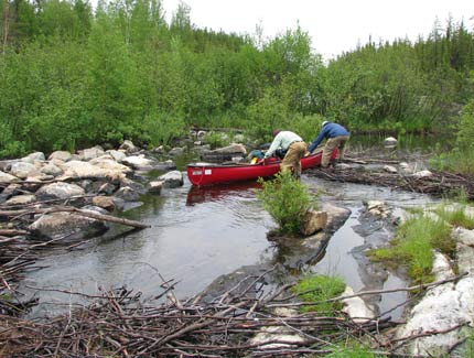
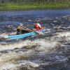
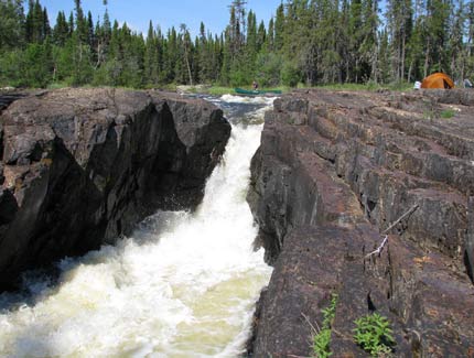
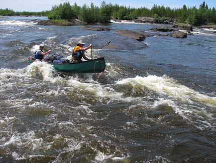
Below Bigstone Lake we finally realized we were on a river with several runnable Class II rapids. Mostos Falls was a 10’ waterfall requiring a short portage. Our day ended at Ox Canyon, so named by a local canoe outfitter. This was an awesome gorge where the river poured through a notch about six feet wide at the top end, then boiled 70 yards downstream between steep rock walls. The next day we covered 10 miles on flat-water with a few nice rapids to spice up the day. The river braided through large islands beginning at mile 68.5, but there was some current and even a couple of ledges to run. Then the river flowed through narrow channels between islands. We encountered numerous short rapids and ledges that required scouting from the bank. Most were runnable, but we lined over a couple of ledges and portaged once. Duane and Doug, however, found their canoe trapped in fast water with no eddy in which to stop and were swept over a vertical ledge with turbulent whitewater below. Their canoe washed onto a large rock, but water poured over the side breaking gunnels and a seat bracket while wrinkling the hull. They also lost a tackle box, shirt, sponge, and their pride. Duane made hasty repairs and floated the canoe to our evening campsite where more substantial repairs were accomplished with parachute cord and duct tape. Later that day we encountered so many islands we were not certain of our location at our evening campsite. The first 12 miles from camp to the Hill River were full of islands and short rapids. There was a really long, Class II-III rapid at mile 48.0 that we all enjoyed. After lunch at mile 42.5, there were no more campsite possibilities and the rocks soon disappeared.
From the Hill River onward we were in the Hudson Bay lowlands. Bedrock was replaced by deep soil. The river bank was lined with a 10’ tall willow thicket backed by black spruce.
We ran half-way down Camp Rapid and found a campsite on the right bank where a rock outcrop extended into the woods. Right after leaving that camp, we ran two short, but challenging rapids. Dan and I bailed five gallons of water from our canoe after the second drop. For the next 2½ miles to Great Falls the current was swift.
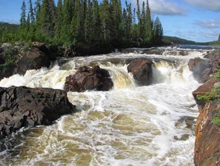
At Great Falls the river dropped over 60 feet in 1½ miles through a maze of river channels. We lined several times and portaged once to negotiate a half dozen six-foot to ten-foot drops. Runs between ledges were tough Class II-III with one being a bonified Class III that required negotiating big standing waves at the top of the rapid, ping ponging through a boulder garden with very fast water and ending with a furious paddle to the left bank to avoid a disastrous ledge. Six hours later we emerged from Great Falls–the toughest short section of river I ever negotiated! After leaving Great Falls we had good current for eight miles then it slowed for the final seven miles to Rainbow Falls.
A half mile above Rainbow Falls there was a very nice cabin with a mowed lawn on the left bank. We were invited by the owners to camp on the lawn and come in for dinner. Jason and Debby Crozier, along with their young boy and girl were very happy to see visitors. They knew we were coming because they were friends of the pilot, Pat, who was scheduled to pick us up at their cabin on Friday. In fact Pat and his wife came to dinner that evening so 10 people assembled at this riverside cabin for dinner. Jason fried walleyes and grilled pork to go with potatoes, fresh vegetables, beer and wine. It was a scrumptious dinner for starving canoeists. Jason, Pat, and their wives told us stories about catching big sturgeon, hunting moose, and living in Gillam, their home town.
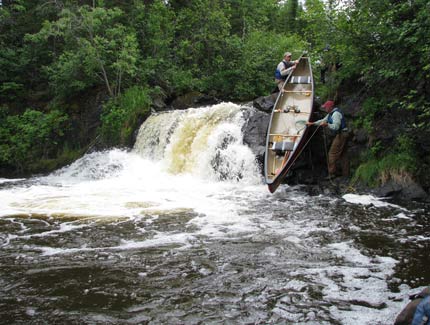
After breakfast we paddled down to Rainbow Falls and portaged empty canoes around it. This was the most spectacular waterfall I have ever seen on a canoe trip. The river dropped about 35’, but was spread over half a dozen waterfalls that poured into a chasm with boiling water. We spent over an hour photographing different views of the falls as well as interesting rocks and plants.
Overall this was one of the most physically difficult canoe trips I have taken because of rough conditions for lining and portaging as well as the strength and experience required to negotiate numerous big rapids.
Campsites:
There was very little evidence of previous canoe travel on this river. Consequently natural campsites were small and sometimes required cutting brush and moving rocks. We usually camped on firm ground, often adjacent to bedrock. We had one campsite on a sandy island covered by tall grass in the Hudson Bay Lowland section.
Topography:
The first half of our trip was on the edge of the Canadian Shield with some bedrock exposure and low hills. From the Hill River onward we were in the Hudson Bay lowlands where bedrock was replaced by deep soil and the landscape was quite flat. In general topography was not very dramatic, except for the numerous rocky rapids we encountered. There were very challenging rapids and falls at Great Falls. Of course Rainbow Falls was exceptionally beautiful.
Vegetation:
Spruce and jack pine were the dominant tree species. A large burn extended from mile 81.5 to 64.5. In the Hudson Bay Lowlands the river bank was lined with a dense willow thicket 10’ tall backed by black spruce. There were grassy islands in mid-stream.
Insects, Fish & Wildlife:
Blackflies and mosquitos were serious pests throughout the trip in mornings and evenings. They did not bother us too much during daytime.
We did not have much time for fishing because of our arduous days of paddling and negotiating rapids. When we took time to fish, however, we caught walleyes and northern pike around rocky islands in the lakes and in pools below rapids.
The marsh along Mistasinni Creek was alive with ducks, geese, sandhill cranes, and the occasional eagle. During the trip we saw a couple of dozen cow and calf moose—more than I have seen on any other canoe trip. They were especially common in the Hudson Bay Lowlands. We also saw a few woodland caribou, otter, beaver, snowshoe hare, woodchuck, eagle, raven, sandhill crane, Canada goose, loon, cormorant, ducks, and shorebirds.
Canoes & Equipment:
We paddled a Bell Alaskan and a Nova Craft 17’ Prospector with lining ropes, but without spray skirts. We used both straight and bent-shaft paddles.
Topographic Maps 1:50,000: From www.worldofmaps.com: 63 I/15 Bjornson Lake, 63 P/2 Cotton Lake, 63 P/1 Allbright Lake, 53 M/4 Powstick Lake, 53 M/5 Cuddle Lake, 53 M/6 Schwatka Lake, 53 M/11 Ransom Lake, 53 M/10 Palmer Lake, 53 M/15 Hawes Lake, 53 M/16 Couture Lake, 53 N/13 Kekayaw River.
Float Plane (Information Outdated): Manitoba Air, (204) 652-2109
Expenses per Person (US $): $1,198 total, including gas $210, food $190, water filter $11, 2 nights motel $90, car shuttle Cross Lake to Gillam $100, boat shuttle on Cross Lake $150, satellite phone $48, fishing license $32, partial car and canoe repairs $32, gifts to Canadian families that helped with logistic $30.