Snowdrift River Summary
Northwest Territories, Canada
June 19 – July 15, 2014
By Mel Baughman, Hayward, Wisconsin
For a complete journal with more details, contact the author—baughman@umn.edu.
Crew: Mel Baughman, Brian Arquilla, Dan Godwin, Mark Hansen, Tim Krohn, and Christian Nelson
Route:
Two of us drove from the Minnesota/Wisconsin area to Yellowknife and transported three canoes and gear for five people while the others flew to Yellowknife. Our 2200 mile vehicle route required 41-hours of driving (including time for meals, gas, and rest rooms) spread over three days with two nights in motels. There were good paved roads over the whole route, although the last 100 miles were bumpy. Alexandra Falls just north of the Northwest Territories border and woodland bison in the MacKenzie Bison Sanctuary were highlights of the drive. We had a free day in Yellowknife to insure that everyone made it there in time for our float plane trip.
From Yellowknife we flew eastward across Great Slave Lake in a Twin Otter for 1 ½ hours to the east end of Sandy Lake–headwaters of the Snowdrift River. This long, narrow lake, surrounded by sandy hills and beaches was gorgeous from the air and from the ground. During the flight we spotted numerous forest fires across the landscape. Smoke haze obscured the sun during most of our trip downriver.
During our canoe trip, we traveled a total of 103 miles. We paddled 12 miles westward on Sandy Lake, then 66 miles down the Snowdrift River, crossed 4 miles over a height of land to Nomans Lake, paddled 7 miles down Nomans Lake, then portaged into Nonacho Lake, and paddled 14 miles to a final campsite.
While it might seem logical to paddle the Snowdrift River to its mouth on Stark Lake near the village of Lutselk’e, the last few miles of that route drop over a very steep hillside requiring extremely difficult portaging. On the Internet I found one report of a group that took that route and made it, but most canoeists look for other routes. A route mentioned on the Internet departed from the Snowdrift River somewhere north of Siltaza Lake and followed a series of small lakes and numerous portages to Stark Lake, but I could not find any specifics on that route. Rob Kesselring departed from the Snowdrift River just south of Siltaza Lake and portaged southeastward into Nonacho Lake. Since Rob’s report made that portage sound long and difficult, we chose our northern portage route as a potentially shorter, easier route. We were wrong. Our portage was probably more difficult than the route that Rob took.
River Conditions:
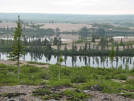
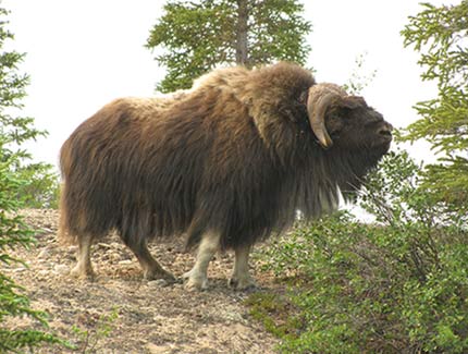
The scenic landscape around Sandy Lake was a highlight of the trip. We spent just two days on that lake, but if I were to canoe this river again I would spend at least three days on Sandy Lake to fish and to hike on sand hills and the tundra. We also saw more muskoxen and signs of grizzly bears around Sandy Lake than anywhere else on the trip.
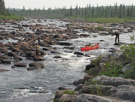
The Snowdrift River also was very scenic with high sandy banks and beaches. Its clear water probably averaged 8 feet deep and there was a sandy bottom throughout. The river typically was 50 to 150 yards wide. In the first 13 miles below Sandy Lake, we encountered several long rock gardens that were really difficult to negotiate. We dragged canoes over boulders with deep water between rocks and portaged one stretch. It took 1 ½ days to get through this section. [For those who wish to avoid this difficult stretch, consider beginning your trip on Eileen Lake and paddling down the Eileen River to the Snowdrift River.] Thereafter we encountered several runnable rapids and two portages–each about 300 to 400 yards long. Some rapids required scouting and careful maneuvering to find runnable slots over ledges. Most of the river, however, had a steady current and no hazards.
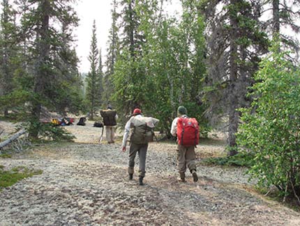
The four-mile crossing between the Snowdrift River and Nomans Lake included about 2 ½ miles of portaging and 1 ½ miles of paddling on small lakes. There was no portage trail. We used a GPS with a topographic map and a roll of plastic flagging to mark a route. Then we employed saws and an ax to cut small trees, limbs, and brush to clear a path. Our pathway included a dense spruce stand, sandy hills, mixed hardwood/conifer forest over rocky hills, and a peat bog. It took two days to cross the watershed divide and we were exhausted each day.
Where the portage route ended at Nomans Lake we found a nice campsite and rested there for two nights, then paddled 8 miles and portaged 100 yards into Nonacho Lake. That portage route had been burned over and was not cleared, but it was not too difficult. We had no particular destination in mind on Nonacho Lake and after paddling 14 miles down the lake, we found a perfect campsite on a large island so we spent four nights there to end our trip. That area offered good hiking on the island, excellent fishing nearby, and a great pickup location on a sandy beach for a float plane.
Campsites:
We always had very good campsites and never had much difficulty finding sites. The first three campsites were on the tundra with scattered trees, but the other sites were in forest. Nearly all sites on the Snowdrift River were on sand—beaches or eskers. Campsites on Nomans and Nonacho Lake had short vegetation, such as moss and lichens on the ground.
Topography:
There were rolling hills throughout this trip. Sandy hills surrounded Sandy Lake. For the first two days of travel downriver, we encountered hills with exposed bedrock. The remainder of the Snowdrift River offered numerous eskers and other glacial sand deposits along the banks. High hills around Nomans and Nonacho Lake showed bedrock, but no sand deposits. This was one of the most scenic river trips I have ever taken, due to sand deposits on the Snowdrift.
Vegetation:
Tundra with scattered spruce trees surrounded Sandy Lake, but within two days after leaving that lake, forest enveloped the landscape. The forest was mainly black and white spruce with scattered paper birch, tamarack and a few balsam poplars. Common shrubs were dwarf birch, willow species, alder, Labrador tea, blueberry, cloudberry, bearberry, crowberry, and cranberry. A forest fire had burned along approximately 45 miles of the Snowdrift River a couple of years ago. Blackened trees remained standing and re-growth had not yet begun so we could still camp and hike through this forest. Older fires had burned forest around Noman and Nonacho Lakes and regrowth was abundant. We had to search for unburned areas in which to camp and hike.
Insects, Fish and Wildlife:
We encountered a few mosquitos in the evenings along the Snowdrift River, but black flies were the biggest nuisance. Black flies disappeared once we left the river and traveled on Nomans and Nonacho Lakes. I used insect repellent only a few times on the trip, but we used a bug tent for shelter at campsites.
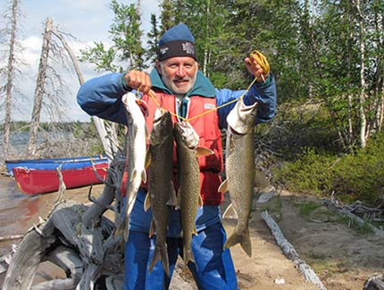
We spent several hours fishing Sandy Lake and hooked a few fish, but did not land any. In a pool below the first rapid after leaving Sandy Lake, three of us hooked nice lake trout on our first casts. There I caught my largest trout of the trip, about 10 pounds. We caught only one other laker on the Snowdrift– at the confluence with the Eileen River which had colder water. We fished around nearly all the rapids on the Snowdrift, but caught only a few northern pike and saw a few widely scattered grayling. Fishing was a big disappointment on the Snowdrift. However Nomans and Nonacho Lakes provided excellent lake trout fishing.
On our first evening at Sandy Lake, a herd of at least 18 muskoxen ambled past our campsite. Two days later we saw a lone muskox and obtained great pictures. We saw two moose, as well as a couple of beavers and arctic ground squirrels. Antlers from caribou and moose were common finds. Birds included bald eagle, goshawk, raven, common loon, Canada goose, ducks, jaeger, yellowlegs, terns, seagulls, sandpiper, and other songbirds.
Canoes & Equipment:
We paddled two 17-foot Pak Canoes and a 17-foot Wenonah Spirit II Royalex canoe. All canoes had lining ropes, but only the Wenonah had a spray skirt which proved to be unnecessary. We used ropes to tie gear into the Pak Canoes. We used straight-shaft paddles in white-water and bent-shaft paddles in flat-water. A Lean 3 by Cooke Custom Sewing was an excellent group shelter for protection from insects and wind during meals and leisure time.
Float Plane: Air Tindi, 126 Bristol Ave, Yellowknife, NT, Canada; Office (867) 669-8291; Cell (867) 445-8910.
Approximate Average Cost Per Person: $2668 U.S. including: 86 topo maps, 202 food, 81 satellite phone, 1973 float plane, 151 three nights lodging in Yellowknife (combo of private home and motel), 189 five meals in Yellowknife
Plus either:
$934 Drive from Hayward, WI to Yellowknife & return (food $172, lodging $183, gas $579)
$682 Fly from Winnipeg to Yellowknife & return (food; gas from Cloquet, MN to Winnipeg; taxi;
airfare Winnipeg to Yellowknife & return $615; no lodging-stayed with relatives in Winnipeg; gear was hauled in the pickup so there was no airline baggage fee.)