

Canoe the Heart: Celebrating the Quetico Provincial Park and Superior National Forest Centennial
TRIP LOG: Submitted by Tim Eaton, July14, 2009
The starting point for this leg of the ‘Heart’ was the Ash River Visitors Center on Kabetogama Lake in Voyageurs National Park (VNP). Paddlers assembled at Whispering Pines Cabin 41 on the afternoon of July 4th 2009.

All photos courtesy Tim Eaton unless otherwise noted. July 4th, Kabetogama Visitors Center. Left to right; Holly Armstrong from Quetico Provincial Park, Betsy Ward of Voyageurs National Park, and Rich Kelley from the Quetico Foundation.
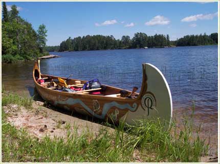
Departure was scheduled for 6 am on July 5th and after a sunrise breakfast the big 27’ North Canoe was rolled over, lifted into the water, the paddling stations are assigned, the gear loaded and with paddlers on board, this leg of the voyage was underway. Time– 6:30 am sharp.
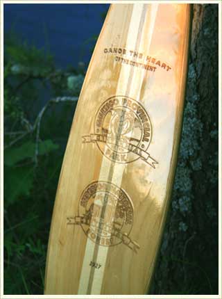
Canoe the Heart paddle carved by Spencer Meaney, Atikokan.
The morning was perfect– the big lake was calm, reflecting a cloudless blue sky above. The early morning temperature was plus or minus 60 degrees, and the day would prove to be sunny and hot, cooled by an occasionally light breeze from the northwest.
This leg of “the Heart” was lead by Kathleen Przybylski of VNP and Rich Kelley of HOCP and the Quetico Foundation. Together they navigated us through Voyageurs, Rich in the stern, Kathleen with her set of maps is the next position aft and Holly Armstrong from the Quetico Provincial Park (QPP) assigned the bow position to lead the crew of six in strokes. Keeping up with Holly proved to be an arduous task for everyone on board, she’s a strong, trim Quetico traveler experienced in paddling the big 27’ Voyageur canoe.
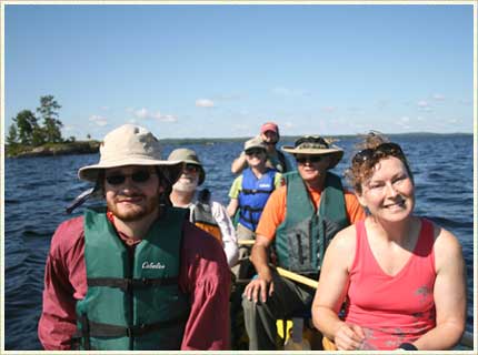
Left to right, front to back—Brandon Baker and Betsy Ward from Voyageur National Park, John Craig, Duluth and Jim Haskell, Friends of Quetico, Kathleen Prybylski , Voyageurs National Park Association and Rich Kelley, Quetico Foundation.
We stopped every 30 minutes to hydrate and switch paddling sides– six of us were seated side-by-side, two to a seat. At the first rest stop, Rich reassigned paddling stations to balance body weights, paddling strengths, and to maximize our performance. We were on a mission and flying across the big waters of Voyageurs National Park. By 10:30 am we covered 20 miles and by lunch 27. We made our final destination, a campsite at King Williams Narrows on Crane Lake, an hour and a half ahead of schedule, at 2:00 pm. We paddled 32 miles in seven and a half hours including our stop for lunch and a refreshing swim.
 The North Canoe. Photo courtesy Jim Haskell.
After setting up camp we paddled three miles further to the Voyagaire Lodge on Crane Lake where we rendezvoused with leg C paddlers and officials from VNP, QPP and Superior National Forest. Leg B paddlers took their leave and leg C paddlers returned to camp to prepare for the next day’s departure to Fall Lake in Ely.
The Route
Distance: 32 miles Time: 7.5 hours.
Morning:
Sullivan Bay on Kabetogama Lake eastward past Old Dutch Bay, Blind Indian Narrows, north of Williams Island and Hoist Bay, turning south of Namakan Island, passing between the narrow passage at Two Alligator Island and into Namakan Lake. Now paddling in Canadian waters with a bearing of due East, past Randolph Island and onto big open water. Six miles out on the horizon is the navigation point Pat Smith Island. Follow the Blind Pig Channel into Namakan Narrows and on into Sand Point Lake.
Lunch stop:
A point of land just north of Burn Island and the site of an old cabin foundation.
Afternoon:
Head southwest past Burn Island for Harrison Narrows four miles down the lake. Continue south another four miles through King William Narrows and to the final destination, a camp site on a point of land just north of Indian Island.
Maps:
McKensie series maps; 1:31,680 scale
K1- Kabetogama
N1- Namakan Sand Point
C1- Crane, Sand Point.
The maps have the U.S. Coast Guard Navigation aids/symbols for motorboat travel.
Highlights:
Big open waters of Voyageurs National Park. The hundreds of islands found throughout the Park. The cliffs of Namakan, Harrison and King Williams Narrows. The pictographs at Namakan Narrows. The flowering Lady Slippers.

Lady Slippers on the shore of Kabetogama Lake.
The interesting names of the islands and bays as well as the stories and tales associated with each (and thankfully, it’s a more peaceful place to paddle these days). A few shared with me by Brandon Baker, Voyageurs National Park Guide:
Old Dutch Bay–Named after Dutch Messenger, a logging camp worker with a temper known to flare with drinking. He is rumored to have knocked a cow flat on its back with one punch after it spilled the food Dutch was feeding it. And he once got in an argument with a freind visiting his home on Old Dutch Bay; Dutch killed him with a rifle got off ree and clear on grounds of self defense.
Kohler Bay–Little is known for sure about Kohler, for whom this bay was named. All we know for sure is that he came up to the area for privacy. When people kept coming into his bay however, Kohler stood on his point and shot at at anyone who came to close, including one unfortunate game warden who beat a hasty retreat. After this people were more than happy to leave Kohler alone.
Pine Covia–Once home to I.W. Stevens, who hailed from Norway. He lived alone on the island until he was 97. He grew his own food, cut all his own firewood, and hauled water by hand. The winter cold kept his cabin warmer at 50 degrees F, so he built a “throne” that allowed him to sit with his head almost touching the ceiling, the warmest spot in his house. He also had 100 toothbrushes that he rotated throughout the year and constantly boiled.


