Woodland Caribou Provincial Park – Artery Lake to Lund Lake
TRIP LOG: Submitted by Mel Baughman, May 2015
Ontario, Canada
August 15 – 26, 2013
By Mel Baughman, Hayward, Wisconsin
For a complete journal with more details, contact the author—baughman@umn.edu.
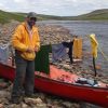
Crew: Mel Baughman, John Nordin, Mike Prouty, and Dan Godwin
Route:
Woodland Caribou Provincial Park is located west of Red Lake, Ontario and borders Manitoba. Its 1.1 million acres of wilderness hosts only about 800 paddlers per year, but hundreds more utilize the park through its fishing lodges and outpost cabins.
We drove from the Minneapolis/St. Paul, MN or Hayward, WI area to Red Lake Ontario in 11.5 hours. The next day Viking Outpost Air flew us in a Cessna and a Beaver float plane from Red Lake to Artery Lake in the northwest corner of the Park.
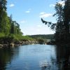
Over the next ten days we paddled about 55 miles upstream (eastward) along the upper Bloodvein River through Artery, Mary’s, Barclay, Larus, Murdock, Knox, a series of small unnamed lakes, and Lund Lake. Our trip ended when we portaged out of Lund Lake to a dirt road where Red Lake Outfitters picked us up in a van and transported us 80 km back to Red Lake.
During our ten day trip in late August, we saw only one other canoeist, but we frequently saw a few powerboats on big lakes that spoiled the wilderness atmosphere. To minimize powerboat sightings, paddle in August or September and avoid big lakes where outpost cabins and lodges are more likely to be found.
River Conditions:
Planned as a leisurely fishing trip, we paddled 5 to 10 miles per day, spending two nights at each of three campsites and one night at each of four other campsites.
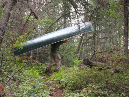
We portaged 11 rapids totaling 2.78 miles. Our longest portage was nearly a mile. There were portages between all the big lakes, but most portages were concentrated in the last two days of travel. We chose to travel upstream from west to east so that our packs would be lighter and we’d be in better physical condition for longer portages at the end of our trip. There was a barely perceptible current in the short, river-like sections and all rapids would need to be portaged regardless of the direction of travel. All portage trails had been cleared by trail crews, but not to the standards of most trails in the BWCAW. Our crew members were all over age 60 though, and we had no difficulty negotiating portages. Our toughest portage occurred in a burned forest between Larus and Murdock Lakes where newly fallen trees and new tree growth made travel difficult. I’ve seen much worse conditions on other trips, though.
Despite the long portages, this was a relatively easy canoeing experience. Nearly all paddling took place on lakes with just a few short river-like sections. Bent-shaft paddles were adequate for the entire trip. We used Kevlar canoes and appreciated their light weight on long portages. Anyone who has successfully paddled in the BWCAW could complete this trip.
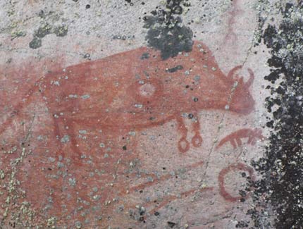
Pictographs and Artifacts:
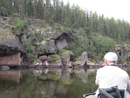
Rock faces on cliffs and boulders provided sites for pictographs– a highlight of the trip. We found pictographs and other interesting relics at these sites.
- On a cliff just before the narrows heading west out of Artery lake at Mile 56 ¼, there was a pictograph painted red and shaped like a six pointed star or asterisk*. [Mileages were measured upstream from the canoe landing on the east side of Lund Lake (Mile 0).]
- On a cliff on the west side of Artery Lake about one mile north of Site 1 as we paddled toward Ted’s Lake, there was a pictograph that looked like the tips of a turkey’s tail spread out or maybe the back of a porcupine.
- On the east end of Artery Lake at mile 53, we saw a beautiful rock cliff with numerous pictographs including a canoe with a person in it, bison, human stick figures, and abstract drawings.
- On Larus Lake at our campsite on a large island at mile 30.5, there were wooden teepee poles propped against a tree.
- At the western end of Murdock Lake at mile 24, we found a high cliff with numerous pictographs: canoes with people, stick figures of people, and numerous hand prints.
- At the eastern end of Murdock Lake at mile 16.2 on a small rock face, we found two drawings. One resembled a beaver while the other resembled a mammal on four legs.
- On Knox Lake about ½ mile south of the portage in the northwestern corner is a blue sign written in three languages commemorating the Bloodvein River as a National Heritage River.
Campsites:
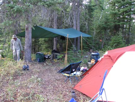
Red Lake Outfitters had a wall map marked with potential campsites. John transposed those marks onto his own topographic map, but we found that only about 25% of those campsites were usable. Many others were obliterated by windblown trees, fire, and regrowth due to lack of use. We often used a saw and ax to clear tent spaces even on the best sites, but we always ended up with very suitable campsites typical of those in the BWCAW, but without toilets or fire rings.
Topography:
The Canadian Shield landscape had numerous granite outcrops and picturesque cliffs that sometimes rose over 40’ high. Overland hiking was difficult because of dense woodland, but Dan and I hiked to the top of a cliff at the north end of Knox Lake and enjoyed the elevated view.
Vegetation:
The dense forest was composed mainly of jack pine, white and black spruce, balsam fir, quaking aspen, balsam poplar, paper birch, and pin cherry. A wildfire had burned the forest from the southeastern corner of Larus Lake through Murdock and nearly to Knox Lake. Our clothes became grimy from soot on portages in this area, but we camped only one night in the burned area and found a good campsite on an island in Murdock Lake that had not been burned.
Insects, Fish & Wildlife:
Insects were not a problem. I put on insect repellent because of mosquitos only twice during the entire trip. We had a bug tent, but set it up only once and didn’t really use it then.
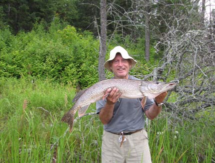
Fishing produced walleyes and northern pike on all of the lakes. We spent most of our time fishing in 6 to 20 foot depths. Walleyes were most abundant over rocky bottom in 8 to 20 foot depths, but we caught quite a few in weed beds. Walleyes ranged from 10” to 18”, but averaged about 14”. Weedbeds in shallow water were full of hammer-handle northerns, but we caught bigger pike around rocks in 8 to 20 foot depths. Pike ranged from tiny tots to 15 pounds. In deep water our most successful strategy was to troll with deep diving plugs until we caught a couple of walleyes in one area, and then to anchor and cast with plugs or twister tail jigs. We gorged on walleye meals a half dozen times.
While diving plugs were very effective at catching fish, three of us were impaled on hooks at some point during the trip. Dan had the worst experience when a small northern jumped out of the water next to the canoe and hooked his left forearm. When Dan grabbed the feisty northern with his right hand to stop it from wriggling, his right thumb became impaled. It took me an hour and lots of advice from everyone in our party to extract the hooks. For just this reason I’ve always feared treble hooks and seldom use them on wilderness trips. Since these plugs were so useful, however, in the future I’ll probably remove all but one treble hook from lures and/or bend down the barbs.
While eagles, loons, seagulls, and ducks were commonly spotted, we also glimpsed otters and a spruce grouse. Moose tracks were common and at the end of the trip we heard wolves howling and saw tracks of wolf and caribou.
Weather:
Weather was warm throughout our trip. I seldom wore more than a T-shirt. We had a few rain showers and fortunately missed two large thunderstorms that hit Red Lake and washed gullies in gravel roads. We usually had calm winds in the mornings, but breezy conditions in the afternoon. For that reason we tried to do most of our paddling and fishing in the mornings. We always set up a large rain fly in our campsite to use as a rain shelter and occasionally for shade.
Outfitter: Red Lake Outfitters arranged for our motel, float plane, car shuttle and camping permits. Contact: (807) 662-5104, solotrip@gmail.com, redlakeoutfitters.com.
Topographic Maps: Customized from MyTopo.com
Costs: The average cost per person was about $920, including gas, food, meals enroute, motel, float plane, car shuttle, fishing license, and maps.