The Middle Track: The Bigstone – Fox – Hayes Rivers
TRIP LOG: Submitted by Duane Lee, March 2, 2009
River Route Planner
Where and What:
NE Manitoba
330 km from the east end of Cross Lake to York Factory
Level of Difficulty:
River Travel: Advanced
Lake Travel: Intermediate
Portage and Lining: Intermediate to Advanced
Bigstone – Fox – Hayes River Trip Planner:
The trip started with a 980-mile drive from Lindstrom, Minnesota to the small community of Wabowden, Manitoba. We arranged for a car shuttle to the community of Cross Lake and a boat shuttle to the east end of Cross Lake where the trip starts. Ending in York Factory requires a float plane back to Gillam. From Gillam we took VIA Rail back to Wabowden to pick up our car.
Transportation:
Coordinate all transportation ahead of time. From York Factory, the only way back is by float plan to Gillam, Manitoba. From there you can take the train back to you car in Wabowden.
We left our vehicle in Wabowden, MB. Carolyn Sanoffsky at My’s Place can make arrangements to shuttle your car from Cross Lake back to the rail-head in Wabowden. Carolyn also coordinated a boat shuttle from the town of Cross Lake to the east end saving us 45 miles of big-lake travel. Carolyn operates a gas station, very nice restaurant and a B&B in Wabowden – I highly recommend utilizing her services.
Gillam Air Contact: Pat, 204-652-2109
VIA Rail: www.via.com
My’s Place Contact: Carolyn Sanoffsky, Box 170, Wabowden, Manitoba ROB 1S0
Difficulty:
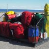
This trip is not for the faint of heart. Once you leave the community of Cross Lake, you will be in an isolated wilderness setting with a high probability of not seeing other people. A high degree of proficiency in white water canoeing and competent outdoor living skills are important. There are two long portages and several shorter ones plus some serious lining of canoes is needed. Some of the portage trails are difficult to find and many are not in very good shape, although one way or another, all are passable.
We carried a satellite phone for emergency communication.
Maps:
1-50,000 scale maps are a must for this route.
SCALE: 1 to 250,000
63 I Cross Lake
63 P Sisiwisk
53 M Knee Lake
53 N God’s River
54 C Hayes River
54 F York Factory
SCALE: 1 to 50,000
63 I/15 – Bjornson Lake
63 P/2 – Cotton Lake
63 P/1 – Albright Lake
53 M/4 – Powstick
53 M/5 – Cuddle Lake
53 M/6 – Schwatka Lake
53 M/10 – Palmer Lake
53 M/11 – Ransom Lake
53 M/15 – Hawes Lake
53 M/16 – Couture Lake
53 N/13 – Kekayou River
53 C/3 – Chura Lake
54 C/7 – Caruso Lake
54 C/10 – Prost Creek
54 C/15 – Gillam Island
54 C/16
World of Maps: 800-214-8524, www.worldofmaps.com
Wilderness Registration:
The Royal Canadian Mounted Police (RCMP) of Canada provides a Wilderness Registration Service for all wilderness canoe trips. It is highly recommended that you use this free service.
RCMP: Box 309, Gillam MB R0B 0L0, 204-652-2436
This and That:
I have been canoeing North Rivers for over ten years and the Bigstone – Fox – Hayes remains one of my favorites; I have done this trip twice. If you like small rivers, lots of fun white water, great fishing, a fair amount of hard work, lots of wildlife (moose and waterfowl) and some of the prettiest waterfalls around this may be a trip for you.
————————————————————————————–
Trip Journal:
The Rivers:
The Mistisini creek is a small and shallow stream winding its way up to the height of land that will take us to the watershed leading downstream to The Bay.
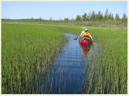
Paddling upstream from a shallow bay at the east end of Cross Lake we entered a river grass. Stepping out into knee-deep water, we pushed and pulled the canoe until we came to a large beaver dam. Portaging over, we found enough water to paddle. For the next two days, this would be played out many times, paddling the areas behind the beaver dams and then as the water ran low and the river became a sea of grass again, we pushed and pulled the canoe to the next open water stretch.
ter two days of upstream paddling, we portaged our outfit up and over the height of land on an ill-used portage. The portage trail was overgrown with brush, shrubs and small trees, a narrow footpath snaked its way thru woods, marsh and finally over shield rock ending at the source of the Bigstone River.
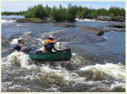
The Bigstone is aptly named as during the next five days we ran many boulder-infested rapids that were sometimes short on water, bumping and grinding our way downstream. Flowing through clay silt uplands the river would increasing become constricted and forced through rock outcroppings and over boulders. Running these rapids required a deft paddle to avoid the many rocks and boulders strewn about the river channel. In some places we had to wade thru fast water lining our canoes as we went.
Many sections seemed almost impassable. Running out of water we were reduced to putting beaver cut logs under our canoe and rolling it across the rock-strewn waterway. Then back in the canoe to do it all over again.
And the river spun its own magic and mystery when one day the water completely disappeared under the bedrock and we had to portage the outfit down a steep cliff-like rock ledge.
Finally, the river opened up and with increased water flow, but there were still more boulders to dodge, hissing rapids to line and white water to run.
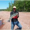
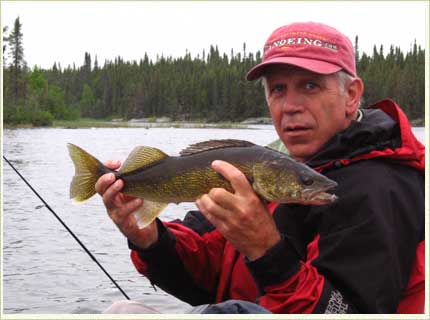
At Ox-Canyon, the river drops 21 feet in less than 50 meters and the entire river is forced through a five-foot wide slit in the tilted bedrock. At the bottom of this raging torrent we jigged for walleyes in the spinning eddies.
Entering the Fox River, the river volume doubled and picked up speed. For several days the river was sprinkled with magical names on the map: Camp Rapids, Great Falls, Rainbow Falls, the Pennycuttaway River.
At Great Falls, the river braids into many channels and the trick is to try and guess the right channel. Part way into the falls area, we gave up trying to track where we were on the map. The braided channels weaving in and out created a navigational mess.
Running a rapid around an island, we scared a cow moose that ran and then swam down the rapids in front of us while her calf followed from behind our canoe. Eddying out, we watched them clamor up the hillside and into the brush.
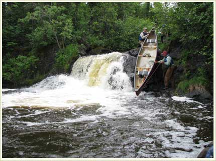
At one point we came to an almost impasse. The main river was a mix of steep rapids and waterfalls that couldn’t be run or lined and the option of portaging was daunting as thick brush and a tangled mess of a forest confronted us. To the north of this conflagration was a narrow channel. Taking this we encountered two ten foot waterfalls: we lined fully loaded canoes down one and portaged the next. Finally, the passage around The Great Falls was done.
Rainbow Falls is perhaps the most impressive series of falls and rapids that I have seen in the North Country. In four miles, the river drops over 90 feet. Camping before the start of the first falls provided an excellent place to explore the upper falls area as well as take a much-needed swim in a quiet pool. The horseshoe shaped upper falls initially cascades 25 feet and then drops another 15 feet before washing out into a large bay below.
Once past Rainbow Falls, the main rapids were over. The Fox becomes a large river on the move as evidenced by the constant mini-whirlpools that churned us downstream. With 75 miles to go, the Fox enters the historic Hayes River; River of the Voyageur. The Precambrian shield rock gives way to clay banks erode down to the river’s edge, the water gets cloudy and we put away our fishing rods.
A few more miles and we round a bend. The river doubles in size and the volume increases, notable as the God’s River joins the Hayes in the restless march to the sea. With a 30 mph tail wind, we set sail and ride the winds downstream – 45 miles in one day. Just sit in the stern, put your feet on the gunnels and hold onto the rudder!
Along this stretch of river the trees become stunted, the bedrock disappears and the unstable clay banks become the dominant land feature. Now all camping is done on the many gravel sand bars.
York Factory:
With growing anticipation we make a last push to York Factory. York Factory on Hudson Bay was first built in 1783 as a trading post and transportation depot to the interior. The existing two-story building dates from 1823 and is now a Canadian National Historic Site. During the heyday of the fur trading industry, York Factory was home to some 1,500 Hudson’s Bay Company personnel and Cree natives. Rounding a bend in the river we saw the large red HBC flag flying high from a pole on the point – and then the massive two-story post comes into view.

As with the trappers and traders before us, we couldn’t wait to land our canoe and get to the post. Pulling ashore we met up with Jim and Betty, who are the caretakers of the post. Over a cup of coffee and homemade carrot cake, Jim and Betty talked about growing up in the north. Betty shared how she grew up on North Knife Lake in a one-room trappers cabin. Trapping in the winter and fishing and hunting in the summer and fall sustained the family.
With the coffee pot empty, Jim suggested we take the tour of “the Factory” building. The two-story white clapboard building with a modest center court yard and a third story cupola provided a tremendous view of the surround area.
Each summer, a ship laddened with goods would arrive to pick up furs and resupply the post. As the main Hudson Bay Company depot, a two-year supply of goods were assembled, repackaged and then shipped to interior trading posts scattered throughout western and northern Canada. Built entirely out of wood cut from the forested areas upstream, the building was never heated in the winter for fear of fire. One can only imagine the working conditions during the cold bitter winter months.
Walking east of the post, we came to a modest cemetery. With graves dating back to the early 1830’s, this is the third known cemetery location; others build too close to the restless riverbank have washed into the Hayes River. As caretaker for the past 30 years, Jim has reclaimed this cemetery. The grass is neatly mowed; each grave has a wooden picket fence surrounding it. Some of the graves have etched stones, while others are marked only by a simple wooden cross, most of which are leaning leeward.
With the rustling of the poplar leaves, I close my eyes and am transported back to the days of the fur trade. The excitement of the re-supply ship bringing news from England and goods to an isolated people. York Boats plying the Hayes River loaded to the gunnels with furs to send back to England. Natives coming by birch bark canoe to trade furs for trade goods.
The buzz of a floatplane transports me back from a time long past. It’s time to go home.