Quoich River Summary
Nunavut, Canada
July 11 – August 12, 1989
Crew: Mel Baughman, Judy Geck, Gayle Knutson, Bob O’Hara, John Quaife, and Steve Schmidt
Route:
Bob and Gayle traveled to Baker Lake, Nunavut a couple of days ahead of the others, following the same route as the rest of us. Four of us departed Minneapolis, MN at 2:00 pm on July 11, then drove 17 ½ hours to Thompson, Manitoba, arriving at 7:30 am on July 12. Although our train did not depart Thompson until 8:25 pm, we wanted to allow several hours of extra time for the road trip in case we had any travel problems. While in Thompson we enjoyed touring a nickel mine. We stored our vehicle at a YWCA. Our train took 12 ½ hours to travel to Churchill, Manitoba. Tree cover gradually diminished until we reached tundra about 70 miles from Churchill. While in Churchill we visited retail shops, a very nice Eskimo Museum, Parks Canada office with exhibits on early settlement of Churchill, and a ½ hour movie on polar bears. Late in the afternoon we took a boat ride across the Churchill River to Fort Prince of Wales for a one-hour guided tour of this historic site. On the return trip our boat traveled around the river for an hour to let us see beluga whales up close. We stayed overnight in a motel and walked around Churchill the next day (July 14) until our commercial plane departed at 3:15 pm. Following stops in Arviat and Rankin Inlet, we arrived in Baker Lake. We were met by Bob and Gayle and then proceeded to repack all our packs for canoeing, pitched tents next to an airport building, and ate supper. On July 15 a single-engine Otter on wheels and floats took us on a 1 ½ hour flight in two trips to a small lake at the headwaters of the Quoich River, northeast of Baker Lake. We aimed for Snow Bunting Lake, but our pilot landed at another unnamed lake five miles further downstream. I think our pilot was concerned about shallow water upstream that we would need to negotiate if we had landed at Snow Bunting Lake. The next day we began travel downstream. We spent 13 days descending the Quoich River, then spent a layover day at St. Clair Falls. Another half day of paddling took us to salt water on Chesterfield Inlet. After 10 miles of paddling we camped on the Inlet. The next day we followed the incoming tide upstream and entered Baker Lake. We spent six nights and seven days traveling westward on Baker Lake, including a layover day and some partial days windbound before reaching the Inuit settlement of Baker Lake. We spent two nights in Baker Lake at a campground about 1 ½ miles from town, then reversed our trip home: commercial flight to Churchill, night in a motel, train to Thompson, then a long drive back to the Twin Cities in Minnesota.
River Conditions:
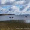
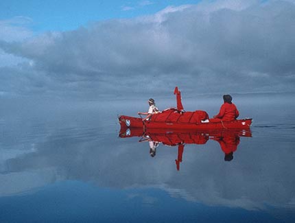
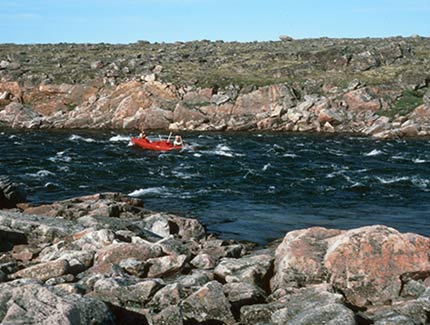
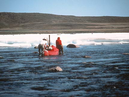
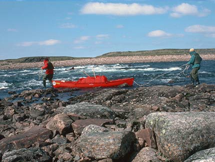
During our first day on the river, we dragged canoes through shallow water and over a snow bank to make 4 ½ arduous miles, but we reached a tributary that doubled the volume of water in the river. I recommend that canoeists begin trips on the Quoich at this confluence or lower down where there is adequate water. For the next two or three days we paddled on the outside bends of the river to remain in the deepest water. Thereafter the standing waves in rapids became so large that we kept to the inside bends of the river. For the first 130 miles downriver there were numerous rapids. We could run most, but lined over a few of them. Then we encountered a 30-foot waterfall and portaged around it. Thereafter we had some short stretches of flat-water, but mostly swift water with periodic rapids that we ran or lined. When the Teherek River joined the Quoich, it nearly doubled the volume of the river, although the river’s width remained the same. Then we had very fast water with huge standing waves and huge boils that aggressively pushed the canoe around. We continued to run most rapids while lining some stretches. Lining was always treacherous because of loose boulders lining river banks. All of us twisted an ankle at some point. There was a scenic set of ledges 172 miles downstream which we lined over. St. Clair Falls was a very impressive set of ledges where the river dropped 60 to 80 feet through a gorge ¼ to ½ mile long. We portaged on the right bank. A few miles below St. Clair Falls we noticed tidal action on the river. For the next 10 miles as we approached Baker Lake, we had to adjust our paddling time to coincide with tidewater movements. We had a tide chart, but Chesterfield Inlet is nearly 100 miles deep and we learned that reported times for high and low tides were off by an hour or more. After a night on the Inlet, we arose very early the next morning to catch a rising tide needed to carry us into Baker Lake. As we paddled upstream, we periodically had to stop for a few minutes to let the tide push further upriver. This was the outlet of the Thelon River heading to the sea. Once we reached Baker Lake we found it to be absolutely calm, so we paddled to Rio Island at the eastern end of the lake. Shortly thereafter, however, we became windbound. For the next several days we had strong winds and had to battle during brief lulls to continue westward 70 miles toward the Inuit village of Baker lake. We averaged 17 miles per day until we reached Baker Lake. It was very difficult to travel that fast and we were exhausted at the end of every day! There was little time to fish and to explore the land.
Campsites:
We usually camped on damp tundra vegetation. At St. Clair Falls, some tents were on bedrock. The only signs we saw of other human use were a couple of sites that appeared to be used by mineral exploration teams and old Inuit camps on the lower Quoich and Baker Lake. There were a few cabins on Chesterfield Inlet and along Baker Lake.
Inuit Artifacts and Experiences:
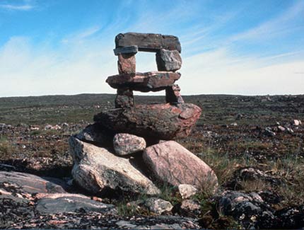
We saw our first rock marker 210 miles downstream. Thereafter rock-on-rock markers were very common and we soon found graves. The area around St. Clair Falls on the right bank were a treasure trove of inuksuit, rock tent rings, shallow pits, graves, meat caches, and a kayak stand. On Chesterfield Inlet we found numerous rock markers on an island, but did not stop to inspect them. Along the shoreline of Baker Lake we found several Inuksuit. At the eastern end of Baker Lake we found two older Inuit people who could speak no English, but they invited us into their tent for tea and we shared pilot biscuits, and jam. The Inuit couple was searching for soapstone to carve and sell. While camping at the Baker Lake village campground, kids visited us often and were curious to talk to us. Most adults older than about 25 did not speak English.
Topography:
Topography was relatively flat throughout this trip, but there were some scenic rocky cliffs periodically along the Quoich. The entire landscape was quite rocky for the first half of our trip.
Vegetation:
The entire trip was in the tundra. Vegetation was sparse on the rocky upper Quoich River, but greener on the lower Quoich and around Baker Lake.
Insects, Fish, Wildlife:
For the first half of our trip down the Quoich we had only mosquitos, but thereafter both blackflies and mosquitos tormented us.
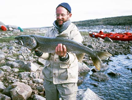
Fishing was excellent in the Quoich River for both grayling and lake trout. I caught grayling up to 16” and lake trout up to 15 – 20 pounds. We also caught a combination of grayling, lake trout and arctic char at the mouth of the Ketyet, Akutuak, and Prince Rivers along the shore of Baker Lake. Char were just beginning to approach the rivers, however.
We saw only a handful of caribou. We learned later that the Inuit refer to the Quoich as the “River of Starvation”. We saw a few arctic ground squirrels, peregrine Falcons, jaegers, ducks, and Canada geese.
Canoes and Equipment:
We paddled Old Town Discovery 174s with spray skirts and lining ropes. Spray skirts and lining ropes were essential for this trip because of the high volume rapids as well as for paddling big waves on Baker Lake. We had a large tundra tarp for wind and rain protection over our cooking area. We did not have a bug tent since they were not generally available at the time of this trip, but it would be a useful addition. We paddled straight-shaft paddles in white-water and bent-shaft paddles on flat-water.
Travel Arrangements: Bob O’Hara made all of our travel arrangements so I have no notes on those contacts, but this trip took place many years ago so that information would be outdated anyway.
By Mel Baughman, Hayward, Wisconsin
For a complete journal with more details, contact the author—baughman@umn.edu.