


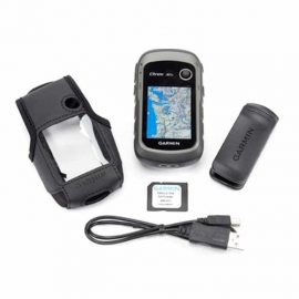
Garmin TOPO U.S. 100K
Download or MicroSD Card
We've mapped every hill and valley for your next great adventure. Now with more detail than ever, this product covers the finer points of the outdoors with topographic maps comparable to 1:100,000 scale USGS maps. It also includes terrain contours, topo elevations, summits, parks, coastlines, rivers, lakes and geographical points.
$99.99
Provides detailed digital topographic maps, comparable to 1:100,000 scale USGS maps.
Includes updated road content, by HERE (non-routable).
Contains detailed hydrographic features, including coastlines, lake/river shorelines, wetlands and perennial and seasonal streams.
Includes searchable points of interests, such as parks, campgrounds, scenic lookouts and picnic sites.
Provides elevation profile on compatible devices so you can estimate terrain difficulty.
Contains roads, trails and highways in metropolitan and rural areas, so getting to your destination is easy when you create point-to-point routes on compatible devices.
Displays national, state and local parks, forests, and wilderness areas.


There are no reviews yet.