

Navigation
Showing 13–24 of 87 results

Waterproof. Navigate your way through the ninth section of the Northern Forest Canoe Trail—from Rangeley Lake to Spencer Stream—with NFCT Map 9 and take in the stunning views of the Bigelow Preserve, the Appalachian Trail, and Grand Falls.
$9.95

Waterproof. Navigate your way through the first Maine section of the Northern Forest Canoe Trail—from Umbagog Lake to Rangeley Lake—with NFCT Map 8 and explore lots of undeveloped, conserved land and sensitive wildlife habitats.
$9.95

Waterproof. Navigate your way through the middle of the Northern Forest Canoe Trail—from the Connecticut River to Umbagog Lake—with NFCT Map 7 and explore the Great North Woods at the northern edge of the Presidential Range in the White Mountains.
$9.95

Waterproof. Navigate your way through the last Vermont section of the Northern Forest Canoe Trail—from Lake Memphremagog to the Connecticut River—with NFCT Map 6 and explore the Northeast Kingdom, Clyde River wetlands, the Nulhegan River, and the Silvio O. Conte National Fish and Wildlife Refuge.
$9.95

Waterproof. Navigate your way through the fifth section of the Northern Forest Canoe Trail—from the Missisquoi River to Lake Memphremagog—with NFCT Map 5 and explore the rolling hills, dairy farms, and forests along waterways historically used by the Abenaki and later by Europeans traveling between Quebec and the New England settlements.
$9.95

Waterproof. Navigate your way through the fourth section of the Northern Forest Canoe Trail—from Lake Champlain along the Missisquoi River—with NFCT Map 4 and explore the forests and swamps of the Missisquoi National Wildlife Refuge.
$9.95
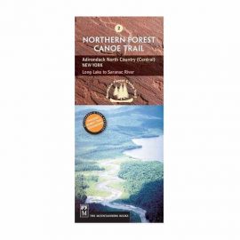
Waterproof. Navigate your way through the second section of the Northern Forest Canoe Trail—from Long Lake to the Saranac River—with NFCT Map 2 and explore the historic route of early loggers and hunters.
$9.95

Waterproof. This map covers the Connecticut River from its headwaters and 280 miles south to the Massachusetts border. Includes all access points, campsites, portage trails, and information on the area natural and cultural history.
$9.95
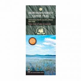
Waterproof. Navigate your way through the beginning of the Northern Forest Canoe Trail—from the Fulton Chain of Lakes to Long Lake—with NFCT Map 1 and explore the historic path of Iroquois trappers, Adirondack guides, and early steamboats.
$9.95

Download
Outdoor enthusiasts: your adventure is waiting — in vivid detail. These highly detailed maps include terrain contours, topo elevations, summits, routable roads and trails, parks, coastlines, rivers, lakes and geographical points. They also display 3-D terrain shading on compatible devices.
Outdoor enthusiasts: your adventure is waiting — in vivid detail. These highly detailed maps include terrain contours, topo elevations, summits, routable roads and trails, parks, coastlines, rivers, lakes and geographical points. They also display 3-D terrain shading on compatible devices.
$99.99
Download
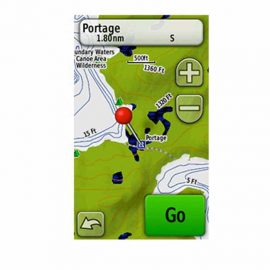
Get highly detailed inland lake and topographic maps for the Boundary Waters Canoe Area Wilderness. These maps include freshwater lakes and rivers, high-definition shorelines, underwater depth contours, terrain contours, elevations, summits, portages and camping areas.
Get highly detailed inland lake and topographic maps for the Boundary Waters Canoe Area Wilderness. These maps include freshwater lakes and rivers, high-definition shorelines, underwater depth contours, terrain contours, elevations, summits, portages and camping areas.
$99.99
Download
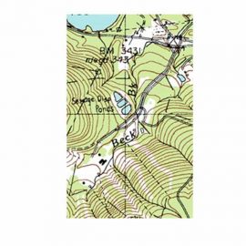
We've mapped every hill and valley for your next great adventure. Now with more detail than ever, this product covers the finer points of the outdoors with topographic maps comparable to 1:100,000 scale USGS maps. It also includes terrain contours, topo elevations, summits, parks, coastlines, rivers, lakes and geographical points.
We've mapped every hill and valley for your next great adventure. Now with more detail than ever, this product covers the finer points of the outdoors with topographic maps comparable to 1:100,000 scale USGS maps. It also includes terrain contours, topo elevations, summits, parks, coastlines, rivers, lakes and geographical points.
$29.99


