Pere Marquette River, Baldwin, MI
TRIP LOG: Submitted by Jeff Winston, February 17, 2008
The Pere Marquette, or “PM” as it’s called locally, is known as perhaps the finest barrier-free stream in the United States. Beginning in south eastern Lake County, just west of Reed City, Michigan, it stretches over 180 scenic miles to its mouth opening into Pere Marquette Lake. A portion of these waters along with part of the main branch, totaling almost 49 miles, was designated as a “National Wild and Scenic River” in 1978. The lower main branch, totaling almost 100 miles, from M-37 downstream and a large portion of the South Branch remains open to paddlers and anglers year round.
April 1 – 3, 2006
The Pere Marquette River is a National Scenic River flowing through the Huron-Manistee National Forrest. It is a hugely popular river during the summer months. That is one of the reasons that we chose to paddle the PM so early in the year.
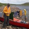
We did not use an outfitter or livery for this trip. We dropped our canoe and gear off at M-37 bridge in Baldwin, MI. for the launch, then drove our car (20 miles) to Walhalla Bridge for take-out. We had a family member follow us to Walhalla to return us to M-37. Much cheaper and easier than a livery. There is a simple dirt lot at Walhalla bridge to leave your car. No fees, and we had no issues with leaving the car there. By the time we returned to the M-37 bridge for put-in, it was 4:15 pm and 44 degrees.
The river was mildly swift, but quite manageable. The PM is a famous around these parts for steelhead and trout fishing, so there were plenty of anglers around. All were very respectful and did their best to get out of your way. In most cases, we tried to scoot between them and the shore to not disturb them or their fish. Just remember . . . when the river is swift and you can’t accommodate the anglers . . . the canoe has the right of way.
We stopped at Gleason’s Landing for the evening. This was a very nice campsite. We set-up camp, had dinner and went to sleep. Temp is 38 degrees at 10 pm, expecting lows in the 20’s overnight. Because it is off-season, the camping was free. During the summer, it is $12.00 per night. Gleason’s landing is 8.4 miles downriver from M-37.

We got up at 7 am and prepared breakfast and packed-up the tent and gear. We were back on the river by 9 am. The weather radio is telling us that we can expect thunderstorms and hail in the afternoon, so we are going to try to get as far as we can early-on in the day. Another gorgeous day on the river. We stopped for lunch at rainbow rapids. This is a stop just before you hit the actual rapids on the river. I’m not sure how precarious these rapids are in the summer months, but they were AWESOME on this spring trip. There were virtually no obstacles because the water level was high. It was swift, open and clear, and a whole lot of fun. The rapids were the high-point of the river. At around 3 pm, we arrived at Sulak State Access Site. Fearing the latest weather report, we were debating whether we should continue on, or not. Just as we decided to continue on, it started raining. So we camped at Sulak. Sulak is a nice clean campsite. However, there is a hike of .2 miles straight up a steeply inclined road to get to the camp area. This was murder with all of our gear. We set-up the tent right away and tried to keep our gear dry with the tarp. We cooked dinner under the tarp and went to bed early, around 9 pm. The rain turned into thunderstorms in the middle of the night.
We woke up at 7 am and it was still raining. We tuned in to the weather radio and it said that snow and flooding were on the way. We’d much rather paddle in snow than in the rain, so we went back to bed to wait out the rain. The snow started at around 10 am, so we got up had breakfast and started packing, we were on the river at 12:00 pm.
The river has risen 10 inches since yesterday due to the rain. It has also increased in speed and decreased in managability. It was very difficult to fight the river on its many switchback turns, but we managed. We arrived at Walhalla bridge at 4:00 pm.
There are several other choices for camping and stopping which include two canoe-in only campsites which we would have liked to try, but the weather wouldn’t let us. We did stop and check out Elk camp which is about 45 minutes past Sulak, it was very nice, only 4 campsites and first-come, first-serve. The canoe-in sites and Gleason’s landing are the only places where you can camp right on the river. Because it is a national scenic river, you can camp anywhere on national forest or state land, as long as you are 1/4 mile inland from the river. The Pere Marquette map issued at the ranger station shows a red-line where you must pass in order to camp.
This river is good for beginners, we listed it as moderate because of the extreme weather, flooding, and time of the year. Personally, I would recommend doing this river during the off season, because you almost have the river to yourself (and the anglers).
Fees:
In order to prevent overcrowding on this popular river, permits are required from May 15 – September 10 from Forks Landing to Custer Bridge. Although the permits are free, they are controlled so that only a certain number of permits are issued per day. There is a non-refundable reservation fee of $2.00.
There is also a vehicle pass required if you park at the National State Forest, that fee is $3.00/day, $5/week, or $20.00/annually.
Directions:
M-37 north from Grand Rapids until you get to Baldwin. M-37 south from Traverse City until you get to Baldwin. Very easy to find.
Resources:
Stop at the National Forest Ranger Station just north of the M-37 bridge and pick up the river map and other info about the campsites.
Paddling Michigan by Kevin Hillstrom and Laurie Collier-Hillstom
Canoeing Michigan Rivers by Jerry Dennis and Craig Date
The Back-Country Kitchen by Teresa Marrone
I highly recommend this cookbook. We have used it for a couple of trips and the meals are excellent, easy to pack and lightweight (because you dry most of the food ahead of time).
It is very important to have a weather radio with you. As we prepared for this trip, we monitored the weather from home for a week straight. Once we arrived in Baldwin, the weather and the forecasts changed almost every hour.
Copyright © 2008
Jeff Winston