Kopka River
Ontario, Canada
June 27 – July 6, 1997
By Mel Baughman, Hayward, Wisconsin
For a complete journal with more details, contact the author—baughman@umn.edu.
Crew: Mel Baughman, Judy Geck, John Quaife, Guy Mueller
June 27:
We drove from the Minneapolis/St. Paul Area to Grand Marais, MN and stayed overnight in John’s cabin.
June 28:
We drove for five hours to Mattice Lake Outfitters just south of Armstrong, arriving at noon. During the afternoon we flew 55 miles on two separate Beaver airplanes to Redsand Lake, headwaters of the Kopka River. While flying across the lower Kopka River, we saw three magnificent waterfalls we would need to portage around later.
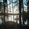
Knowing we had to paddle just 75 miles in 7 ½ days, we camped immediately. Our campsite had a large slab of granite along the shore and a cushion of moss and lichens beneath our tents which were protected from the wind by jack pines and spruces. The only distractions were a fishing outpost cabin a quarter mile away. During the afternoon we saw a couple of motorboats and a float plane landed at the cabin. We fished for a few hours catching seven northern pike from two to four pounds. While paddling around the lake, we saw two eagles, several loons, and one beaver. No-see-ums and mosquitos were a minor nuisance.
June 29:
Redsand Lake was dead calm as we headed north. Two eagles flew across the lake. A fire had burned trees around the north end of Redsand and the south end of Siess Lake. There was another cabin at the north end of Siess Lake. We covered 11 miles of flat-water by noon. Mergansers and loons were frequent visitors. We fished briefly at a few mid-lake rock piles and caught a couple of small northerns. By 3:00 we made Gaal Lake and found a mediocre campsite on an island. It had a good canoe landing and decent tent sites, but not much open space. Guy and I caught several small northerns in the lake then headed downstream until we came to the top of a rapid that we did not want to descend. From there we walked downstream along the rough, brushy shore. At the base of the rapid, we caught four walleyes and several northerns. Our campsite was at mile 58. We canoed 16 ½ miles.
June 30:
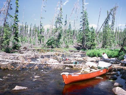
After leaving camp we soon entered a narrow mile and a half of river. It was shallow and weedy with a sand bottom, except through a couple of narrow, rocky chutes where fallen trees spanned the river. We dragged over them and continued. We caught a few walleyes and northerns in holes below rapids. In a mile-long lake we caught several northerns and one walleye. It was windy and we stopped for a rest break in an old campsite. Then we entered another mile and a half of narrow river and again dragged through a couple of rapids with fallen trees. On Uneven Lake we paddled east then north, taking rest breaks about every 1 ½ miles. One motorboat passed us and we saw a fishing resort with at least five cabins in the northern section of Uneven Lake. We continued past it another two miles spotting two beavers along the way, and then found a campsite perched on a small hill 20 feet above the lake. It was our best site yet on a breezy promontory with an excellent view up the lake. After pitching tents we fished around some nearby islands and caught numerous small northerns. Our campsite was at mile 45 ½ on the north end of Uneven Lake. We paddled 12 ½ miles today.
July 1:
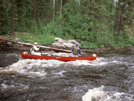
About 1/10-inch of rain fell last night, but the sky was clear when we launched our canoes. Our trip began with four miles of flat-water on a lake and ended with six and a half miles of river. The river was 40-50 yards wide and shallow with a very slow current, but there were numerous rapids and one portage around a series of rocky ledges. Fishing often, we caught several northerns and walleyes. In mid-afternoon we started saving walleyes and kept four for a fish fry. We saw an osprey as we entered Sandison Lake. Our campsite was not easy to find, but it had been used before and was an excellent site with lots of flat bedrock areas and two good tent sites. Spruce and jack pines offered wind shelter. The air temperature was cooler today, maybe 70 for a high. We covered 10 ½ miles ending at mile 35 on Sandison Lake.
July 2:
Rain fell through the night and the wind blew. We slept late and awoke to 54 degrees and gray sky. The river water was 67 degrees. While paddling away from camp I soon spotted an osprey. We had gray sky and wind all day. Light rain began when we stopped for lunch on a house-size boulder on the river’s edge. Rain intensity increased during the afternoon and continued until we went to bed, drenching all of us. Fortunately it slackened to a mist at the end of the day. Although most of our mileage was on lakes, a half dozen narrow stretches of river with rapids added excitement. We portaged three times at miles 34, 28 ½, and 25 3/4; lined once; and ran several more rapids. We unexpectedly found a logging road crossing the river at mile 28 ½ just upstream from the portage trail. That particular rapid was a very pretty series of drops through a rocky gorge, but the portage trail was littered with fallen trees making the portage difficult. The third portage also had some fallen trees, but it was shorter and easier. We fished at several rapids catching walleyes and northerns. We had difficulty finding a campsite, and finally selected a huge, breezy granite outcrop. A few trees on top were used to hold up the ends of our rainfly. We pitched tents on deep moss back in the woods. Mosquitos were voracious, even during the rain. We had not seen many until today. Our camp was at mile 25 after paddling 10 miles.
July 3:
A moose browsed near our tent last night. I heard it stripping vegetation and tromping through the brush, but didn’t see it. The sky was gray when we awoke, but the rain had quit. Most of our canoe route was through narrow lakes, but we had three portages at miles 24 ½, 22 ½, and 19. Fortunately the portage trails were clear of fallen trees. The rapid at mile 22 ½ had a series of picturesque drops. There also were several other interesting rapids to run. We saw one bald eagle. There was an outpost fishing cabin on Hook Lake just above Kenakskaniss Lake. Fishing for walleyes and northerns was excellent below the portage at mile 19. Our camp was at mile 17 on Kenakskaniss Lake. It was a well-used campsite with plenty of good tent sites and a large open space of bedrock. A car-sized boulder at the water’s edge served as a windbreak for our cooking stoves. Clouds dissipated during the day. The wind blew moderately, but died down in the evening. Mosquitos came out as the wind subsided.
July 4:
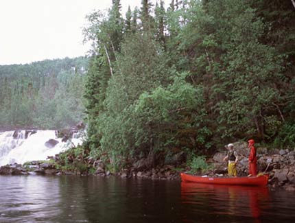
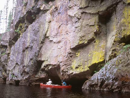
After a leisurely breakfast, we quickly cruised 3 ½ miles to the outlet of Kenakskaniss Lake. There appeared to be many potential campsites on the south end of the lake. We did not see them up-close, but the bedrock shelves receding into spruce and aspen forest looked inviting. This lake was bordered by the first large aspen stands we saw on the trip. Upriver the forest was mainly conifers with only scattered birch and aspen. We paddled through a short rapid at the lake’s outlet and had fun catching walleyes in the pool below. A short distance downstream we ran another rapid, but had to drag through the end of it to avoid a hazardous, rock-filled drop. Then we encountered a hazardous portage over a field of boulders that bypassed a long rapid. Below it we encountered the first of three huge waterfalls. We had seen these from the air and had heard wonderful tales about them from other canoeists before our trip began. They more than lived up to our expectations. An Ontario Ministry of Natural Resources brochure said the river drops 250 feet through these falls. The first fall had at least three major drops totaling perhaps 100+ feet. The river twisted around a curve and was nearly inaccessible from shore in some places so I couldn’t see all of it clearly. The portage trail was perhaps 100 rods and had a steep downhill pitch at the end. We were able to hand the canoe down the rock ledge without using ropes. Paddling into the pool below the fall, we saw its last, spectacular drop that was not visible from shore. It was a gorgeous site.
Then we made a very short portage (10 rods) around a rapid. Just below that we encountered the second portage and fall. This portage was similar in length to the first, but at one place it required walking 10 feet across logs sunken below water line in a marsh and then lifting the canoe onto a rock ledge and wrestling it up a 20′-high rock hill. The trail was steep at the end, but we could carry the canoe down the slope. This second fall was a drop of about 80 feet through a foaming waterslide. The small lake below had outstanding scenery: a 20-foot waterfall on a creek, a deep rock cleft with 100′ cliffs that were painted with colorful mosses and lichens, and several other beautiful, multi-colored cliff faces. We considered camping on this lake, but the next portage appeared challenging so we decided to get it behind us.
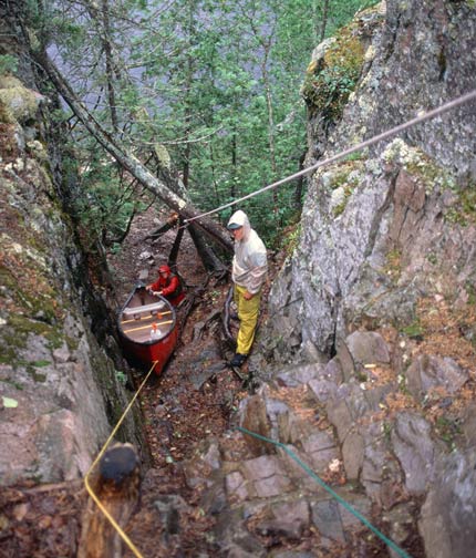
The portage around the third waterfall was short (about 30 rods), but ended in a 130-foot drop through a narrow, rock crevice. This drop began with a shear, 15-foot cliff that was followed by a rock slide that descended steeply to the river below. There was a heavy, fixed rope down the cliff and steep incline. We used it and our canoe lining ropes to lower ourselves, gear, and canoes down. If we’d had a carabiner, we could have used it to slide our gear down the fixed rope. This would have saved wear and tear on our gear as well as time. Instead our procedure was to tie a piece of gear (e.g., canoe, pack, bundle of fishing poles) to the end of a 3/8″ diameter lining rope, wrap the rope one turn around a tree at the top of the cliff, and lower it slowly downhill. We used most of three 50-foot lining ropes tied together at the ends to reach the river below. We had two people on top and two below the cliff. This portage took us about an hour and a half. A thunderstorm blew through as we negotiated this drop, but it didn’t interfere with our work. After loading our gear into canoes, we paddled around the corner to see the falls. Here the river dropped about 80 to 100 feet in two falls. We took a few pictures but the sky was dark and rain was falling. This one-mile stretch of river with its three huge waterfalls, cliffs, and crevices was one of the most beautiful sights I’ve seen east of the Rockies. It made the whole trip worthwhile.
We paddled a quarter mile downstream and set up camp in the rain. The site was small, but 50-foot cliffs backed by a 400-foot hill across the river were very pretty and we could get the greatest echoes I’ve ever heard. Rain stopped when supper was ready. Small patches of sun and blue sky drifted by during the evening, but more rain appeared imminent when we went to bed.
July 5:
After breakfast we paddled upstream to view the cliffs and third waterfall that we had seen only briefly the day before during a rainstorm. They were beautiful sights. I had expected to see other people around the waterfalls, but we had them to ourselves. Then we canoed 12 miles to our takeout at the southeast corner of Bukemiga Lake, arriving at 12:45 pm. Enroute we ran a rapid entering Wigwasan Lake and portaged from that lake into Bukemiga. We saw several motorboats on Bukemiga. Before starting the drive home, we drove a mile to where the Kopka River crossed the road and bathed in the river. About 6:00 p.m. we arrived at John’s cabin in Grand Marais, sorted out the group gear, and then ate supper in town.
July 6:
We were up by 5:30 a.m. and ate breakfast at S.O.B. in Grand Marais. Guy and I headed home together. John and Judy planned to remain in Grand Marais a few more hours to visit John’s mother. Guy and I arrived in the Twin Cities at noon.
Topographic Maps 1:50,000: 52 G/16, 52 H/13, 52 I/4, 52 I/3
[1:250,000 scale maps are not adequate for navigation on this river.]
Float Plane: Mattice Lake Outfitters Ltd., (Wabakimi Air Ltd.), P.O. Box 157, Armstrong, Ontario, POT 1AO, (807) 583-2483; toll free: 1-800-411-0334
Trip Costs: $342 U.S. Per Person, including: 189 float plane, 8 car shuttle, 30 car gas, 45 food, 16 restaurants, 23 fishing licenses, 28 topo maps, 3 long distance phone
–