John River Summary

TRIP LOG: Submitted by Mel Baughman, May 2015
Alaska, United States
September 1 – 10, 1994
By Mel Baughman, Hayward, Wisconsin
For a complete journal with more details, contact the author—baughman@umn.edu.
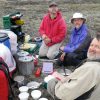
Crew: Mel Baughman, Bill Peppler, Bruce Schoenberg, Colin Riley
Route:
We flew commercial airplanes from the Twin Cities in Minnesota to Bettles, Alaska. The trip took two days with an overnight in Seattle. We arrived in Bettles at 3:00 pm and departed at 7:00 pm the same day on a chartered Beaver on floats for the 88-mile flight to Hunt Fork Lake in Gates of the Arctic National Park in the headwaters of the John River. From the lake we portaged 100 yards to the John River and paddled a couple of miles downstream before camping to get away from a sow grizzly and three cubs that we spotted while landing. We spent the next 8 days paddling 88 miles down the John River followed by 4 ½ miles of upstream lining on the Koyukuk River to Bettles. Although there was supposed to be a phone available at the mouth of the John River to call for a boat shuttle, we could not find it, hence we lined upriver. Even in high water, lining was not particularly difficult. We walked on wide gravel bars along the inside bends of the Koyukuk, but had to paddle furiously while ferrying across the river as it changed course. At the conclusion of our paddle we stayed overnight in a small cabin in Bettles, then flew out the next morning.
River Conditions:
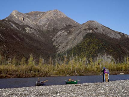
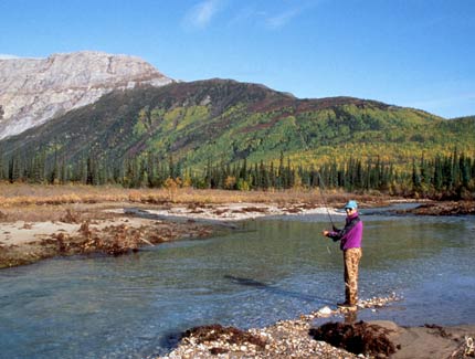
At its normal water level, the John is a clear-water river known for its grayling fishing. When we arrived it was just beginning to recede from a major flood that left the river opaque with mud and gravel bars on which we camped were covered with silt. The river dropped 36.3 feet per mile for the first 5 ½ miles, 8.3 feet per mile for the next 24 miles, and 3.7 feet per mile for the last 53.5 miles. There were numerous sweepers along the river, but the river was wide enough for us to bypass them. Sweepers were only a concern in the upper river where swift, narrow channels braided between islands. There were no significant rapids and no portages. The river averaged about 200 feet wide. One high, rock cliff along a bend in the lower river was quite scenic. A few motorboats passed us while we traveled downstream. There were a couple of cabins on the river.
Topography:
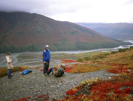
Our trip began in the Endicott Mountains which are part of the Brooks Range in Gates of the Arctic National Park. Mountains rose 4,000 feet above sea level. Scenery was spectacular, especially on clear weather days. Early in the trip we hiked up some mountains for great views. As the trip continued, mountains receded from the river, leaving flat land nearby.
Vegetation:
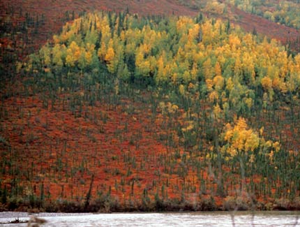
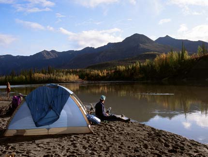
The mountains were nearly bare of vegetation, except for patches of low, spreading shrubs on their lower flanks. Short balsam poplars covered gravel bars while spruce inhabited wet lowlands. Early in the trip vegetation reached its peak of fall color, but those colors paled quickly with the cold nights. Balsam poplars were bright yellow while low shrubs on the tundra above were often red. It was worth tolerating cold night-time temperatures to experience fall colors on the tundra!
Insects, Fish and Wildlife:
There were no problems at all with insects because of below freezing temperatures at night.
Although the John River is noted for its grayling, high, muddy water shut down the fishing on the John. We caught a few grayling in tributaries that began clearing sooner than the main river. I would have enjoyed a day of fishing and hiking along McKinley Creek, but we devoted just a few hours to it. We also caught a few chum salmon in a clearwater pool on the John, but they had spawned and were weak fish.
During our initial flight to the upper John River we saw several grizzly bears as well as a cow and calf moose. On the first morning a herd of about a dozen bull caribou ran through our campsite. Thereafter we saw a few caribou on the mountains each day until the mountains receded from the river. A sow with two cubs approached close to one of our campsites but ran off as soon as it detected us. As the mountains were replaced by flatter land covered with spruce and willow, we saw several moose.
Campsites:
Campsites were relatively easy to find. All campsites were on gravel or sand bars along the river. Because of recent flooding, silt covered the gravel and sand. We frequently pitched a small tarp for rain shelter.
Canoes and Equipment:
We rented canoes and ended up with a beat up 18-foot, aluminum Grumman and a 16-foot, plastic Coleman. Another outfitter in Bettles had better quality canoes, but we chose the less expensive outfitter. There were no spray skirts on the canoes. We brought our own lining ropes, although neither canoe had low points of attachment for those ropes. We had two 2-person tents and a small rain fly. The rain fly was especially useful, although we generally had to pitch it among 10-foot tall balsam poplar trees. Temperatures at night were typically in the low 30s and we always had cold feet in the morning. Rubber boots did not provide adequate insulation, especially when they became wet inside. A campfire warmed us in the morning and at night. Daytime temperatures generally rose to the upper 40s and 50s. Be prepared for cold, rainy weather.
Topographic Maps 1:250,000: Wiseman, Alaska; Bettles, Alaska
Flying Service & Canoe Rental:
Fairbanks to Bettles, commercial air service: http://en.wikipedia.org/wiki/Bettles_Airport
Bettles to John River, float plane service and canoe rental: Brooks Range Aviation, P.O. Box 10, Bettles, AK 99726, phone 907/692-5444.
Gates of the Arctic National Park: P.O. Box 74680, Fairbanks, AK 99707-4680, 907/456-0281