

Allagash Heavy
TRIP LOG: Submitted by Kevin French, August 26, 2008
This trip’s planning started on the second day of last year’s trip after the disaster at Long Lake Dam.
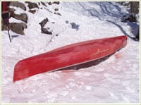
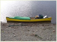
Work started in April repairing the canoe I was going to use. I found it in the dump the year before. It looked like it got frozen in the ice, with cracks on both sides of the mid section. I sanded off the poor patch job from the previous owner and patched it with fiberglass inside and out. I added inserts 6″ down for painter lines, added tie downs on the inside, built a new wooden seat, painted the canoe yellow, added a spray cover, made two paddles and an 11′ pole.
We drove up on Saturday, June 22, met my son in Portland and loaded the last canoe there. We took I-95 to Millinocket, Maine and from there took the Golden Road. We talked with our outfitter, Pelleteirs, about the route to take and where to stay away from.
The first night we stayed at Churchill Dam site. There’s a nice museum there that has a lot of pictures, displays and other material on logging in the area. There are four sites here, all grass covered.
————————————————————————————-
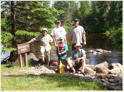
Day 1 – 10 miles to Grey Brook
The next morning we drove down to the Bissonette Bridge to unload the gear. On the way we saw our first moose – looked like a yearling – in the road, and we followed it at a slow pace for about a mile. After unloading I drove back to the ranger station and caught a ride down with him. We used Pelleteirs to shuttle the truck out.
We made our first stop at Chisholm Brook site for lunch and then paddled through Lake Umsaskis to the Grey Brook campsite on Long Lake.
Grey Brook is a great site. It has a couple places for a larger tent, a great beach and isn’t too high off the lake. We watched a couple of moose on the far side of the lake that night. We set the trip up so that each member of the party cooked and cleaned up one evening meal and everyone brought their own breakfast, lunch and evening spirits.
————————————————————————————-
Day 2 – 17 miles to Round Pond Rips
The second day we paddled across Long Lake and down to the outlet. At the outlet we saw 5 moose, 2 cows and a calf. As we passed the area they had been, Alan gave a moose call. The calf returned the call and came back out to the river. OK, a lucky call, we said. He called again, and the calf returned the call again and started to follow us down the river. OK, might be something to the call. As we entered Harvey Pond we saw another moose at the far end.
Continuing, we arrived at Long Lake Dam. Last year we dumped my kayak trying to line the dam. This year we were going to get it right. We lined the two kayaks first and then the two canoes. NO LOSSES.
We passed another moose just above Sweeney Brook site where we planned to have lunch. I set off from the moose and let each of the other paddlers pass between us and snapped their pics.
After lunch we continued down to Round Pond. Passing under Henderson Brook Bridge we saw another moose that followed us down stream for several hundred yards. We had hoped to stay at Inlet site on Round Pond but found it occupied and moved down to Round Pond Rips site. It turned out to be well worth it. Five more moose showed up on the far side of the river. The biggest stayed through supper and spent more than 2 1/2 hours grazing in the river. Round Pond Rips is a fair site – a little rough, but we all had cots so it didn’t matter. The biggest detractor is the open air outhouse if you have modest members.
————————————————————————————-
Day 3 – 13 miles to Deadwater North
The 3rd day on the river we started with Round Pond Rips. Last year we had a lot of rocks here at mid 800 cfs, this year with 1,100 cfs there were few. We had a nice quiet trip through the Musquacook Deadwater. A real peaceful section.
We finished the day at Deadwater North site. Not a bad site. It has a steep bank fairly level for a big tent. We found it better than Deadwater South. That night my grandson and I used the reflector oven to cook blueberry muffins.

————————————————————————————-
Day 4 – 8 miles to McKeen Brook
The 4th day we paddled down to Cunliffe Depot site to look for the old Lombard Lo haulers. First we found a gas powered Lombard and then a steam powered one.
Continuing on we made our mandatory stop at Michuad Farm Ranger Station and found out the river was now running at over 1,800 cfs.
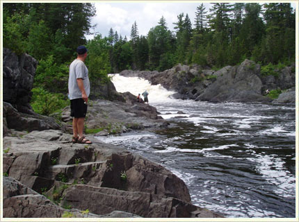
At Allagash Falls we paid for all the gear we brought. It’s an easy 1/4 mile portage and we all had cots, folding chairs, plenty of food….We were going for a wilderness trip in comfort. After the portage we went up and checked out the falls.
We ended the day at Mckeen Brook site a mile and a half below the falls. As with almost every other night we had heavy rains, but like every other night it held off until after supper. There are a couple good sites here but a high steep bank to climb.
————————————————————————————-
Day 5 – 22.5 miles to Pelletiers
The fifth day we planned to stay somewhere around Allagash Village. Not finding a site we liked my son suggested we make for Pelliteir’s Campground 11.5 miles further down river. It was about 1:30pm and having already done 11 miles that day I thought it would be a stretch but everyone else wanted to go. We paddled out onto the St. John and into an unexpected set of rapids. The waves were 18-24″ high (OK, maybe 12-18″ – we are fisherman after all). But they were taller than the boats and by FAR the biggest waves we had seen. And there were three more sets to come, all like the first. I got sucked into the side of a hole. I was glad I had added the spray cover to my canoe as many waves broke over the front of the canoe. My grandson was soaked in the front of the other canoe.
We finished the 11.5 miles by 4 pm – the river was fast. 22.5 miles that day! We had arranged for Pelletiers to shuttle our truck to the campground during our trip. We set up camp and drove to Fort Kent for supper.
————————————————————————————-
Saturday, June 28 – Driving Home
The Allagash river was easier this year due to all the additional water. There were fewer rocks and fewer shallows to deal with. It is a river that just about anyone with any paddling skill can do. Other than the last day we spent about 5 to 7 hours a day on the river, more toward the 5 than 7. The total trip was 70 miles. Even with the big water on the St. John we had no problem getting through it. Totals for the trip: 1 Bear, 19 moose, 15 Bald Eagle, deer, 1 orchid, loons, geese, osprey, and rabbits. We didn’t do a lot of fishing this year, other then my grandson who caught mostly ‘white fish’.
A couple notes on the Northern Forest Canoe Trail maps. We found that some of the sites are not where they say there are. They’re close but most clusters of sites are closer then are represented and on the wrong side of the corner. Also, don’t try to navigate by the island in the St. John. Most are just sand bars.
Some things we’ll change for next year. More baking in the reflector oven, bring a dutch oven, more fishing and most of all next year run Chase Rapids. We liked all the sites we used but will do a little adjusting down stream next year to even the day out especially the last night, moving is down to the Big Brooks or the Twins.
It’s a GREAT trip and we’re going to do it again next year.
Thanks for looking
Sweeper
————————————————————————————-
Resources:
Outfitter, Pelletier’s Campground
http://www.mainerec.com/pellcamp.shtml
Maps
http://www.northernforestcanoetrail.org
The Friends of the Allagash http://awwf.org/


