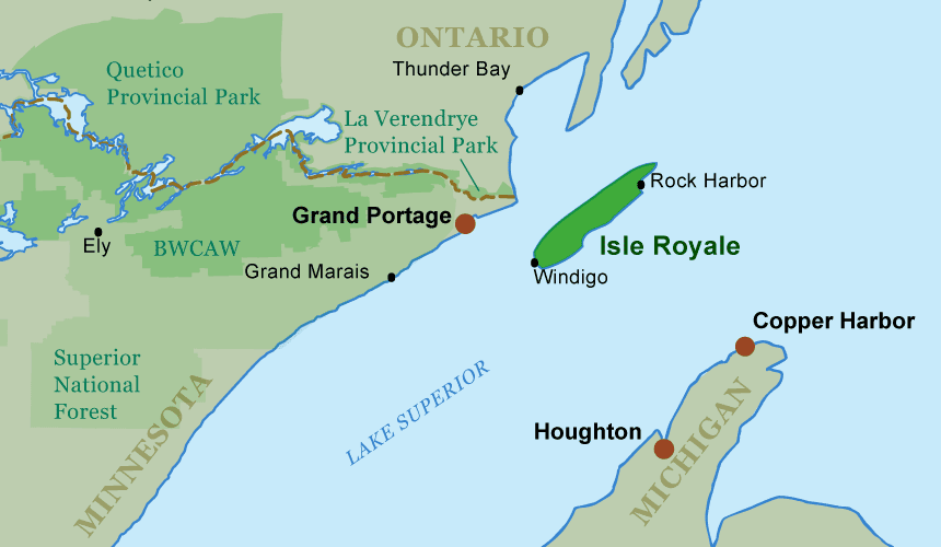
Heading out on Lake Superior can seem a daunting prospect, until you see Isle Royale come into view. The National Park’s 500,000 acres (202,000 ha) are officially a part of Michigan, though it actually lies 45 miles (72 km) from the Upper Peninsula and 17 miles (27 km) from Minnesota. Visitors arrive via seaplanes or ferries that depart from Grand Portage, Minnesota or Copper Harbor and Houghton, Michigan. With 169 miles (272 km) of trails the island is a classic hiking destination, but it also has excellent canoeing on the 9 inland lakes and the fjord-like bays of the eastern shore. Isle Royale is a unique way to experience Lake Superior, not from the mainland as it stretches away from you, but surrounded by it, admiring the gleaming waters from the ridge line or floating atop its mighty swells.
 Explore Canoe Trip Services:
 Park & Permit Info
Visitors to Isle Royale must pay a $4.00 per day user fee. (There are season fee plans for more frequent users.) Four ferries and one sea-plane provide transportation service to the island park. The M.V. Ranger III provides twice-weekly service to the island from Houghton, Michigan. The Isle Royale Queen IV provides service from Copper Harbor, Michigan to the northeast end of the Island. The Voyageur II based in Grand Portage, Minnesota circumnavigates the island servicing many campgrounds. The Wenonah, also located in Grand Portage, services the southwest side of the Island. Royale Air provides service to the Island from the Houghton County Memorial Airport (CMX).
National Park Service: User Fees
National Park Service: Transportation
National Park Service Isle Royale
Unofficial Isle Royale Camping Information
 Fire Information
Campfires on Isle Royale are only allowed at designated campsites with Park Service installed metal fire rings. The National Park Service restricts campfires for aesthetic and ecological reasons. Backpacking stoves are recommended for backcountry cooking.
National Park Service: Isle Royale Park Info
 Maps & Routes
The National Park Service offers a map of Isle Royale online for basic trip planning. National Geographic’s Maps Illustrated offers a waterproof map suitable for backcountry travel.
Canoe routes are limited on and around Isle Royale due to the geography of the island and the tempestuous nature of Lake Superior. The Park Service recommends paddling only on inland lakes. Adventurous, big-water paddlers with patience to wait out questionable weather could travel around parts of the island using the shelter of the bays and coves.
Some routes in the island park include:
————————————————————————————
Malone Bay to McCargoe Cove
2-5 days, Moderate
This all-inland waters route starts at Malone Bay on the southeast of Isle Royale and follows a series of lakes and portages to the head of McCargoe Cove on the northeast side. Paddlers start with a portage into large Siskiwit Lake. From there they can follow marked portages to Intermediate Lake and Lake Richie–both have canoe campgrounds. From Richie, the route heads north through Lake LeSage, Lake Livermore, and Chickenbone Lake (where there’s another campground) to McCargoe Cove. The longest portage on the route is 224-rods. Trippers can return to Malone Bay via the same route or by extending the return trip to the east over the 382-rod portage into Chippewa Harbor (a narrow finger of Lake Superior) and then portaging through Lake Whittlesey back to Siskiwit Lake.
————————————————————————————
McCargoe Cove–Lane Cove–Rock Harbor
6 days, Advanced
Advanced paddlers could mix inland water and Lake Superior paddling in a single trip. Starting at Malone Bay, they could follow the route described above, but travel into McCargoe Bay itself to Indian Point. From Indian Point, they would need to negotiate an open stretch of Lake Superior to reach the portage in Herring Bay. From there they’d follow more protected Pickerel Cove of Lake Superior to Lane Cove. From there, it’s a series of Lake Superior Bays and portages–one 256-rods–to Rock Harbor and the end of the trip.
Isle Royale Map by National Geographic Maps
National Park Service: Official Isle Royale Map
 History
Isle Royale had already experienced a long history when Congress passed legislation creating Isle Royale as a National Park in 1931. Native peoples mined the island for its copper as early as 4000 years ago. In the 1800s, as white settlers and entrepreneurs entered the region, the island was a base for commercial fishing and the setting for a boomlet of largely unsuccessful mining operations. Prior to its becoming a park, the island was the home for a large community of cottages–some of which are still owned and occupied by the families of the original residents.
Isle Royale & Keweenaw Parks Association
North Shore Commerical Fishing Museum
 Ecology
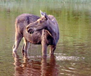
Isle Royale may be best known as the site of a long-term study on the relationship between wolves and moose. The island offers a unique opportunity for biologists to examine the interplay of this predator/prey relationship in the relatively closed system. In 1959 Durwood Allen began the study of the relationship that has lasted until the present and which is currently under the supervision of Rolf Peterson. The study has seen the populations of moose and wolves ebb and flow through the years. The island is fascinating in other ways as well. The island’s isolation causes it to have only a third of the mammalian species found on the nearby mainland. For example, porcupines, coyotes, white-tailed deer, black bear, bobcats, fishers, red-backed voles, short-tailed shrews, and chipmunks are not represented on the island. Indeed moose only arrived there around 1900 and wolves only in the late 1940 or early 1950s.
Wolves and Moose of Isle Royale
 Fishing
Walleye and northern pike are found in the inland lakes of Isle Royale. A rare form of brook trout–coaster brookies–are found in some of the islands interior streams. From the big waters of Gitchi Gummi, anglers can find lake trout and salmon. No fishing license is required to fish the inland lakes and streams of the park, but only artificial bait and lures may be used. Michigan’s season, size and possession limits apply with the exception of restrictions on brook trout special to the park. The Michigan Department of Natural Resources regulates fishing within the Lake Superior waters of Isle Royale National Park. A Michigan fishing license is required and all Michigan size and catch limits apply in these waters.


