 Park & Permit Info
In the Quetico you decide how wild your experience may be.
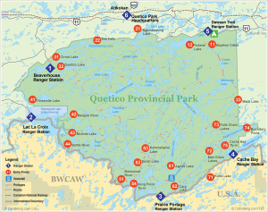
All visits require a permit. Due to the isolation of the park, day-use is uncommon, but the French Lake/Dawson’s Creek Trail and Nym Lake/Atikokan stations on the north side of the park are accessible by car. Dawson’s Creek also has a visitor’s center, campground, showers, and laundromat. Backcountry camping fees are based on length of trip, nationality, and where you enter (the southern access points are more expensive). To see the full list of rates, visit the Ontario Parks fees web page. There are 21 entry points, each assigned to one of 6 ranger stations, 3 of which (Lac la Croix, Prairie Portage, and Cache Bay) are on the Minnesota border.
A limited number of permits are given for each entry point per day, and groups can be no larger than 9 people, so reservations are recommended. Currently, Quetico Park reservations can only be made over the phone and they cost $100.00 plus a$12.00 deposit. They offer peace of mind, however, by guaranteeing you can enter the park at a specific place on a specific day. At least 14 days before your trip call the Ontario Parks reservation line at 888-668-7275.
Choosing a well-traveled loop or forging your own route into the interior will determine how many challenges you set for yourself. There are some designated portages and campsites (without fire grates or pit-toilets), but camping is permitted anywhere. Some portages are erratically maintained and thus can be difficult to find or get across due to thick undergrowth and deadfall. Motor boats are only permitted on Beaverhouse Lake and only to guides on Lac la Croix, so all of the lakes are ideal for canoeing.
CANPASS Remote Area Border Crossing Permits:
If you plan to enter Quetico Park from the United States you must check in at customs as you cross the border, or if paddling in, you need a CANPASS Remote Area Border Crossing (RABC) permit. Citizens and permanent residents of Canada and the US are eligible for an RABC permit. You can apply for an RABC in person at the Fort Frances, Rainy River, Pigeon River, Sault Ste. Marie, Emerson West Lynne ports of entry, or at the Canada Border Services Agency’s Thunder Bay office. You can also apply by mail, which could save you some time and hassle at the border. Three to four weeks before your trip mail your application and the CAN$30.00 processing fee to Canada Border Services Agency, 201 North May Street, Thunder Bay ON P7C 3P4. The application contains instructions on how to apply, what forms of payment are accepted, and what documentation is required. You can also check out these details on the Canada Border Services Agency web site or call their office at 807-624-2162.
Ontario Parks: Quetico
Ontario Parks: Fees
Canada Border Services Agency
Download a CANPASS RABC Permit Application (pdf)
Book: A Paddler’s Guide to Quetico and Beyond Kevin Callan
The Quetico Foundation
 Fire Information
Open campfires are allowed in Quetico Park under normal conditions. You can keep up with fire conditions in and around Quetico via the Ontario Ministry of Natural Resources fire information page or by contacting the park office.
Ministry of Natural Resources: Current Fire Situation
Ontario Parks: Quetico
 Maps & Routes
While the network of lakes, rivers, and portages in the park offer an infinite combination of routes, some classic loops, as outlined on the park website, begin from each of the park’s six ranger stations.
Popular Quetico Park Canoe Routes:
You can paddle the following routes from the park’s northern ranger stations:
Cirrus Lake-The Sue Falls Loop (Beaverhouse Ranger Station)
40 miles (4 days) 5 lakes, 7 portages, Easy
This loop is ideal for those who prefer long, uninterrupted stretches of paddling, with only an occasional portage for leg-stretching. You paddle from the northeast corner of Beaverhouse Lake and then portage east, first to an unnamed lake and then to Cirrus Lake. With nearly half of the route’s portages behind you, paddle to the east end of Cirrus for a view of scenic Sue Falls. Steer south to the longest and most difficult portage of the trip. Upon reaching Kasakokwog Lake, plot a westerly course down McAlpine Creek to another enormous lake, Quetico Lake. Paddling close to the north shore of Quetico Lake, don’t miss ancient rock paintings (pictographs) on the sheer granite cliffs. From the west end of Quetico Lake, the Quetico River carries you back to Beaverhouse Lake.
Baptism Creek-Cache-Kawnipi-Alice Loop (French Lake Ranger Station)
110 km (8 days) 19 lakes, 20 portages, Challenging
Though the Dawson Trail Campground area is possibly the busiest site in the park, the wilderness area just south of it is among the least busy. This route is recommended for experienced and fit paddlers however, for the two Cache Lake portages are long and wet. If you prefer river travel, you can avoid one of the portages by heading down the Cache River to Kawnipi Lake. If you prefer lake travel, continue south to McKenzie Lake and then west to Kawnipi. From there make your way north via Montgomery, Shelly, and Alice lakes, then over the Bonhomme and Sauvage Portages into Fern Lake. From there, only Beg and Bisk lakes separate you from Pickerel Lake. Head east to end your trip on French Lake.
Batchewaung-Twin-Jean-Jesse Loop (Atikokan Ranger Station)
112 km (6 days) 14 lakes, 18 portages, Challenging
This popular route features large and small lakes, creeks and easy portages. Upon reaching Pickerel Lake, paddling through Nym and Batchewaung lakes, steer an easterly course through Pickerel Narrows then head south and southwest through Dore and Twin lakes to gigantic Sturgeon Lake. Paddling through Sturgeon Narrows, going near its west end, enter Jean Creek. After paddling north across Burntside and Jean lakes, bear east on Quetico Lake and continue through Oriana, Jesse and Maria lakes. From there, portage back to Pickerel Lake and return to Nym Lake by reversing the route you followed on the first day.
From the southern ranger stations along the Canada/US border, these routes await:
McAree Lake (Lac la Croix Ranger Station) Easy
McAree Lake is the most convenient of the four entry points accessible from Lac la Croix. From here, it is only three miles to Quetico’s interior. Beyond is some of the most beautiful scenery in the entire Quetico Superior region. Argo and Crooked lakes, Curtain Falls, the Siobhan and Darky rivers and the pictographs of Darky Lake are among the not-too-distant attractions. McAree and Minn lakes are among the 10 lakes in Quetico where native people of the Lac la Croix Guides Association are permitted to use motors no bigger than 10 horsepower. East of these two lakes, however, the only buzzing will be that of the hummingbirds.
Carp Lake-Hunter’s Island Loop (Prairie Portage Ranger Station)
250 km (13 days) 25 lakes, 29 short portages, Easy to Challenging
This route circumnavigates Hunter Island, visiting sections of former fur-trade routes, historic sites, waterfalls and wildlife viewing areas. It offers something for everyone, as long as you’re up to a challenge. Start via Carp Lake and head northeast along the Man Chain (That, This & Other) to Saganagons Lake. Turn north into the Falls Chain to enjoy the collection of waterfalls there. Then into Kawnipi Lake for a long uninterrupted paddle. Make your way via Shelley, Keats and Chatterton lakes to Sturgeon Lake, and then down the Maligne river to Lac la Croix. Turn south and follow the international boundary back to the Prairie Portage area. You should allow one layover day, just in case you get held up by high winds on a large lake.
Falls Chain-The K-K-K Loop (Cache Bay Ranger Station)
168 km (8 days) 26 lakes, 37 portages, Challenging
Doing this route in eight days is recommended for strong and experienced paddlers. Most groups average 10 days. From Cache Bay Ranger Station, paddle to the northeast end of Cache Bay. View Silver Falls at the first portage, then paddle to the north end of Saganagons Lake, taking the Dead Man’s Portage, and begin the journey to the Falls Chain and to Kawnipi Lake. After paddling Kawnipi to its northwest end, go south along Kahshahpiwi Creek, through Cairn, Sark and Keefer lakes, all the way to Kahshahpiwi Lake. From there, portage to McNiece Lake. A chain of smaller lakes and streams leads south to Basswood Lake. From there, paddle northeast along a series of international border lakes back to Saganaga Lake.
Maps:
Official Quetico Park Map
McKenzie Maps
Fisher Maps
 History
Quetico earned its designation as a Forest Reserve in 1909–making 2009 its centennial–and four years later became a Provincial Park. The designations came in step with movement south of the border to preserve this unique area. In addition to land preservation, reserve and park status gave protection to the moose which were under intense hunting pressure at the time. Logging was allowed in the park until the 1970s. However, now the park is strictly managed as a wilderness recreation area and for wildlife preservation.
You can read a concise history of the park on Moose Track Adventures website or, if you want all the details, via Shirley F. Peruniak’s fine book: An Illustrated History of Quetico Provincial Park.
History of the Quetico Superior, from the Quetico Superior Foundation
 Ecology
The inscriptions of the last glaciers decorate Quetico; the exposed Pre-Cambrian bedrock–smoothed, rounded, scratched, and cracked by the ice–provides the foundation for the wild plant and animal life of the park, where wolves follow moose beneath towering pines.
The Quetico forest–at the transition zone between mixed hardwoods of the Lake Superior region and the conifers of the farther north–is composed of coniferous species like the white, red, and jack pine, and black spruce and deciduous trees like aspen and birch.
Large mammals living in the forest include the moose, white-tailed deer, and their prime predator, the timber wolf. The omnivorous black bear haunts the landscape and an occasional campsite or two. Beavers paddle the ponds. Small mammals include the snowshoe hare, the eastern chipmunk and the red squirrel.
Quetico boasts 250 species of birds from the soaring eagles and ospreys to flitting warblers and flycatchers. The hoot of the Barred Owl and the call of the Common Loon provide the background music for the landscape.
Ontario Parks: Quetico
Canadian Border Outfitters: Geology and Natural History
 Fishing
Quetico is a paddler/angler’s paradise–where lake trout, northern and walleye pike, and small-mouth bass are plentiful. In the deeper lakes, lake trout are the most sought after species. However, lake trout, found in deep water once the weather and lake temperatures warm, can be found in shallow water in the spring and early fall.
Northern and walleye pike are present in most of the lakes of the region, with the latter providing the main course of many a Quetico shore-lunch. Northern pike are the easiest to catch as this major predator is one to strike first and ask questions later when it comes to your lure.
In selected lakes, anglers can find small-mouth bass. Small-mouth fishing is best in the late spring and early summer. Live bait is prohibited, accept for leeches, which must be purchased in Canada. See the park web site for details.
As of 2008, live and formerly live bait are prohibited in Quetico Park to prevent the introduction of invasive species to its pristine waters. The Park also prohibits barbed hooks. In lieu of purchasing barbless hooks, conventional hooks may be used if they are modified by pinching down the barbs.
Ontario Parks: Quetico Fishing
Ontario Fishing Regulations
Quetico Park: Remote Border Crossing
PADDLING INTO CANADA FROM THE U.S.
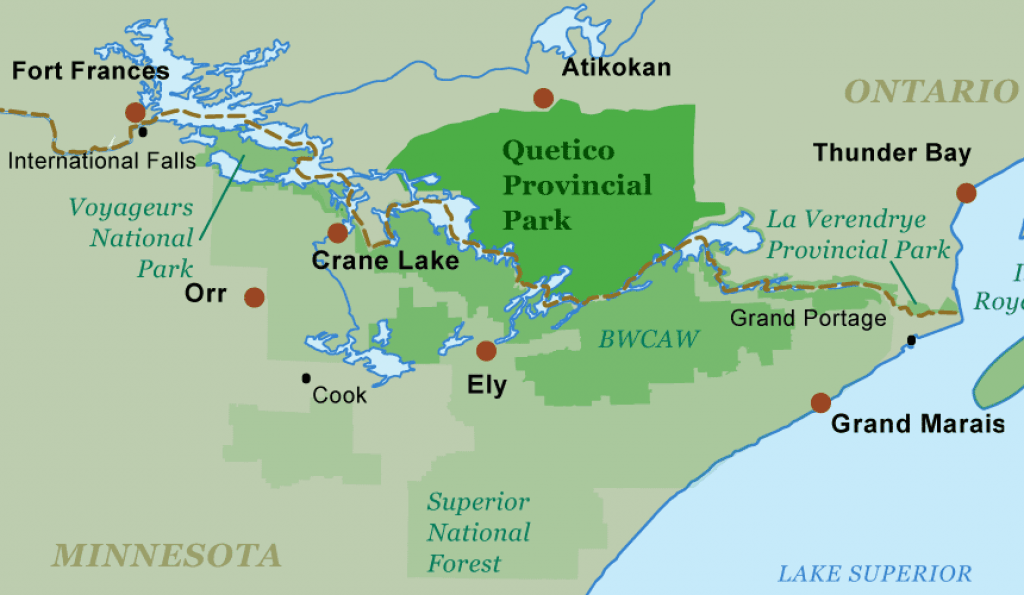
Quetico and the Boundary Waters Canoe Area Wilderness meet along the border between Canada and the United States. Canoeists can paddle across the border, but while the wilderness is contiguous, park management and government regulations are not. Understanding the rules ahead of time will ease your remote border crossing. Read the summary below to get started, and be sure to visit the Canada Border Services Agency web site for the most complete and up to date information.
Entering Canada
To enter Canada from the United States, U.S. citizens must provide documentation of citizenship and identity—such as a U.S. passport or an original or certified birth certificate together with photo identification. Canadians must present a Canadian birth certificate, a Canadian passport, a permanent residence card, a citizenship card or a certificate of Indian status. Children under eighteen need only provide a primary document. For more information on required documentation and entering Canada, visit the CBSA web site admissibility page. Citizens and residents from countries other than the U.S. and Canada should visit the CBSA Citizenship and Immigration page for information on entering Canada.
Remote Border Crossings into Canada/Quetico
Individuals entering Quetico from the United States/BWCAW may enter remotely at Lac la Croix, Prairie Portage, or Cache Bay Ranger Stations. They must obtain a Canadian Remote Area Border Crossing Permit (CANPASS/RABC) in addition to a Quetico permit. The CANPASS RABC program facilitates the border clearance process for remote border crossings at the following locations:
- From Pigeon River through to and including Lake of the Woods
- The Canadian shore of Lake Superior
- Cockburn Island
- Sault Ste. Marie (upper lock system)
- Emerson West Lynne
You can apply for a RABC in person at the Fort Frances, Rainy River, Pigeon River, Sault Ste. Marie, Emerson West Lynne ports of entry, or at the Canada Border Services Agency’s Thunder Bay office. However, it is best to apply for the RABC by mail at least 3-4 weeks before your trip to avoid processing delays at the border. Download a CANPASS/RABC Permit Application.
Mail your application, including photo copies of required identification, and the CAN $30.00 processing fee to Canada Border Services Agency, 201 North May Street, Thunder Bay ON P7C 3P4. For a complete list of required documentation and application instructions, visit CBSA CANPASS web page. The application contains instructions on how to apply, accepted forms of payment and required documentation.
You might not qualify for a CANPASS/RABC if you:
- are not a permanent resident or citizen of Canada or the United States
- have been previously charged with a contravention of customs or immigration legislation
- have a criminal conviction for which you have not been pardoned, such as driving under the influence
- provide false or incomplete information on the CANPASS/RABC application
For more information call the Canada Border Services Agency office at 807-624-2162 or visit this web site.
Note: Trips that originate in the BWCAW and enter Quetico require a BWCAW permit in addition to the Quetico permit and the RABC.
Paddling Into the BWCAW from Canada
Different regulations apply for paddling across the international border into the BWCAW. Learn More >
 Explore Canoe Trip Services:


![800px-Sunset_on_Beaverhouse By Nicholas4343 (Own work) [CC BY-SA 3.0 (http://creativecommons.org/licenses/by-sa/3.0)], via Wikimedia Commons](https://canoeing.com/wp-content/uploads/2016/08/800px-Sunset_on_Beaverhouse-330x250.jpg)
