 Park & Permit Info
Entry Point Reservations and Rules & Regulations:
BWCAW Trip Planning Guide [pdf]
BWCAW Online Reservations/Permits
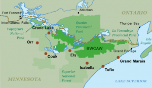
The BWCAW rules and regulations are designed to retain the area’s “wilderness character,” as stated in the 1978 BWCA Wilderness Act. The park is managed by the United States Forest Service as part of the Superior National Forest, whose headquarters are in Duluth with ranger stations in towns across northeastern Minnesota. Motorized watercraft are prohibited except for day-use on a few large lakes around the park’s boundaries. Camping is only allowed at designated sites that have a pit-toilet and a fire grate. To reduce visitors’ environmental footprint they are asked to uphold the Leave No Trace guidelines and groups are capped at 9 people and 4 watercraft.
Human impact in the BWCAW is also moderated by requiring visitors to have a permit. There are several permit varieties depending on what time of year you go and what sort of trip you take: From May 1 to September 30, all overnight stays and motorized day-use require quota permits, but self-issued permits are available for non-motorized day-use. From October 1 to April 30, all permits are self-issued for either day or overnight use. Quota permits should be reserved ahead of time, and then picked up at Forest Service stations or a cooperating organization, such as an outfitter. Self-issued permits do not require any reservation and can be obtained at Forest Service stations, some BWCAW trailheads, and through the mail.
Another result of the permit system is that visitors are encouraged to travel to new places within the wilderness area. Reservations require forethought and invite canoeists to look at entry points all across the map.
The Friends’ Guide to the Boundary Waters
www.recreation.gov
Leave No Trace
Superior National Forest
 Fire Information
The use of campfires in the BWCAW is more controlled than in other popular canoeing areas due to the massive blow down of trees in the forest that occurred on July 4, 1999. Since that event, the U.S. Forest Service, which manages the wilderness, has attempted to moderate wildfire risk with controlled burning. Recent wildfires have also reduced the fuel load.
Paddlers in the BWCAW are advised to keep abreast of wildfire conditions via the USFS BWCAW web site. Paddlers can plan trips using this USFS map which outlines restricted and unrestricted fire areas in the wilderness. As always, visitors are encouraged to use gas or propane cook stoves to reduce impacts to the wilderness.
MN DNR: Current Fire Restrictions
 Maps & Routes
The most commonly used maps for paddling in the BWCAW are those produced by W. A. Fisher Maps and Publications and McKenzie Maps. The maps mark and measure portages, denote campsites, and include topographical contours. The U.S. Forest Service produces a map of the entire Superior National Forest that, while impractical for trip navigation, can help in selecting entry points and planning trips.
The network of lakes, rivers, and portages in the BWCAW creates an infinite combination of routes. Adventurous paddlers can pick an entry point and travel routes to match the time and energy they have to spend. Some basic routes, each launching from the region of a different permit-granting ranger station, are listed below.
Popular Boundary Waters Canoe Routes:
Seagull Lake – Alpine Lake – Red Rock Lake – Saganaga Lake – Seagull River – Gull Lake
1-2 Days, Easy to Moderate
Explore the effects of fire on the Boundary Waters on this canoe route. Read More >
Rose Lake Weekender (Gunflint Ranger Station)
2-4 Days, Easy
Paddlers short on time or in the mood for a quick, easy trip should consider picturesque Rose Lake. From the launch on Bearskin Lake, it’s just two portages to this lovely border lake. A base-camp on Rose is nicely positioned for a day-trip to the Height of Land Portage between North and South Lakes–the drainage divide between waters flowing to Lake Superior and the Atlantic Ocean and those going north to Hudson Bay. In the voyageur era, travelers who crossed this portage heading north earned the title “Men of the North” and the honored status that went with it.
Sawbill–Long Island–Winchell Lake Loop (Tofte Ranger Station)
6 Days, Difficult
With a week to commit to canoe and paddle, trippers can circle a large swath of the eastern BWCA with this route. Heading north from the Sawbill Lake entry point, venture out through Cherokee Lake toward Long Island Lake. From there, you can follow either of two routes to lovely Winchell Lake. From Winchell, head south to massive Brule Lake, but plan extra time in case the winds are unfavorable. From Brule, head back to Sawbill via Knife and Jack, Burnt and Smoke Lakes. The trip includes big lakes and sinuous creeks. There are some long portages and you’ll be covering a lot of ground, but if you’re ready for the trip you’ll be well rewarded.
The Sawbill Lake Outfitters website describes in detail eleven trips to do in the area.
Bald Eagle–Kawishiwi River–Lake Three (Isabella Ranger Station)
4-6 Days, Moderate
From your entry point at Snake Creek which flows into Bald Eagle Lake, you can loop to the northwest via Gabbro Lake and the Kawishiwi River. From the “Kawish,” you can work your way east through the “Number Lakes”–Lake One, Lake Two, and Lake Three. You can extend your trip through, yep, Lake Four toward, nope, Lake Insula, but you’ll need to backtrack to return. (A base-camp on Lake Four, however, offers two nice day-tripping loops to the north and south.) To get back home, portage to Rock of Ages Lake from Lake Two and then from Clearwater Lake return to your entry point via Pietro and Gull Lakes.
Mudro–Fourtown–Basswood River–Crooked–Angleworm (Kawishiwi Ranger Station, Ely)
6 Day, Difficult
This classic BWCAW trip features pictographs, waterfalls, and time spent paddling along the international border. Start at Mudro Lake (but leave a second vehicle at nearby Hegman Lake) and paddle through Fourtown and Horse Lakes and down the Horse River to Lower Basswood Falls. After enjoying and portaging the falls, admire the pictographs downstream made famous in the Francis Lee Jacques painting. (Or camp within evening paddling distance of Wheelbarrow and Upper Basswood Falls.) From there, follow the river to Crooked Lake. If you want to see one more waterfall, paddle beyond Friday Bay on a day-trip to admire Curtain Falls at the outlet of Crooked Lake. Otherwise, portage out of the lake at the bottom of Friday Bay toward Angleworm Lake. From Angleworm there’s a 460-rod portage to get home, but you should be fit and your food pack light by now. At Hegman Lake, you’ll be rewarded for your efforts by the lake’s famous set of pictographs.
Moose River–Lake Agnes–Lac la Croix (LaCroix Ranger Station, Cook)
6 Days, Moderate
Here’s another BWCAW classic: Follow the Moose River north to Nina Moose Lake and Lake Agnes. Then follow the Boulder River North into Lac la Croix. (As an alternative, you can take the less traveled Stuart River–and its 480-rod portage–to reach Stuart Lake, and then follow the lovely Dahlgren River to Lac la Croix.) On Lac la Croix you’ll find two of the landmarks of Quetico Superior country–the Lac la Croix pictographs and Warrior Hill. Off Iron Lake to the east you can enjoy Rebecca and Curtain Falls. You can lengthen the trip and avoid back-tracking by paddling west through Lac la Croix’s Fish Stake Narrows to Pocket Creek and then returning south through Ge-be-on-e-quet, Green, Rocky, and Oyster Lakes back to Agnes.
W. A. Fisher Maps
McKenzie Maps
Voyageur Maps
BWCAW Maps at ShopCanoeing.com
 History
The BWCAW as we know it today was born with the Boundary Waters Canoe Area Wilderness Act of 1978. But a long, often contentious, history brought events to that point. The Shipstead-Newton-Nolan Act of 1930, the first federal law to order the setting aside of lands for wilderness, effectively ended Edward Backus’ plans to impound waters in the area for industrial hydropower. The Wilderness Act of 1964 established the current wilderness preservation system in the country. The next year, a new management plan for the Boundary Waters required permits to enter the wilderness. In 1971 designated campsites were instituted on heavily used lakes. In 1975 designated campsites were made a wilderness-wide rule and allowable group sizes were lowered from 15 to 10 persons. Despite Representative James Oberstar’s bill to establish a Boundary Waters Wilderness Area of 625,000 acres and a Boundary Waters National Recreation Area of 527,000 acres where logging and mechanized travel would be allowed–including on Lac la Croix, Basswood, Saganaga, and Seagull Lakes–the Boundary Waters Act was passed in 1978. Since then, wilderness and multiple use proponents have often used the courts to clash over interpretations of the Act.
History of the Quetico Superior Region
Superior National Forest
 Ecology
Like Quetico Provinicial Park to the north, evidence of the last glaciation in the area sets the stage for the natural world of the BWCAW. The exposed Pre-Cambrian bedrock–smoothed, rounded, scratched, and cracked by the ice–provides the foundation for the wild plant and animal life of the wilderness, where wolves follow moose beneath towering pines.
The BWCAW forest–at the transition zone between mixed hardwoods of the Lake Superior region and the confers of the farther north–is composed of coniferous species like the white, red, and jack pine, the black spruce and deciduous trees like aspen and birch.
Large mammals living in the forest include the moose, white-tailed deer, and their prime predator, the timber wolf. The omnivorous black bear haunts the landscape and a campsite or two. Beavers paddle the ponds. Small mammals include the snowshoe hare, the eastern chipmunk and the red squirrel.
The area boasts 250 species of birds from the soaring eagles and ospreys to flitting warblers and flycatchers. The hoot of the Barred Owl and the call of the Common Loon provide the background music for the landscape.
Friends of the Boundary Waters Wilderness
 Fishing
The BWCAW is known for its wide variety of fishing opportunities. In the deeper lakes, many of them in the northeast of the wilderness, lake trout are the most sought-after species. Lake trout, found in deep water once the weather and lake temperatures warm, can be found in shallow water in the spring and early fall.
Northern and walleye pike are present in most of the lake of the region, with the latter providing the main course of many a BWCAW shore-lunch. Northern pike are the easiest to catch as this major predator is one to strike first and ask questions later when it comes to your lure.
In selected lakes, anglers can find small-mouthed bass. Small-mouth fishing is best in the late-spring and early summer.
Minnesota DNR: Fishing
Remote Border Crossing
The BWCAW and Quetico Provincial Park meet along the border between Canada and the United States. Canoeists can paddle across the border, but while the wilderness is contiguous, park management and government regulations are not. Understanding the rules ahead of time will ease your remote border crossing process.
Entering the United States
Whether you drive or paddle into the U.S. you must have the proper government-issued identifcation on hand.
U.S. citizens entering the U.S. at sea and land ports of entry must have a passport, passport card, or compliant document. Canadian citizens must present a valid passport or other approved document. For more information visit U.S. Travel.State.Gov
Paddling Into the BWCAW from Canada
If your canoe trip starts in Canada and you paddle into the BWCAW from Quetico or the Crown Lands, you must apply for BWCAW permit entry #71. You are also required to report to a U.S. Customs Border Protection officer for inspection at the end of your trip. You can report to inspection locations in Grand Portage, Grand Marais, Crane Lake and Ely. To learn more, call Customs directly at 218-475-2244.
Canoe trips that originate in the BWCA, pass into Canada and then return to the BWCAW do not require Permit #71. Re-entry into the BWCAW is covered by the permit for their original point of entry.
Paddling Into Quetico from the U.S.
Different regulations apply for paddling across the international border into Quetico Provincial Park. Learn More >


