

Lake Powell Trip Log
April 14 – 20, 2017
Submitted by: Vern Fish
Day 1 – April 14, 2017
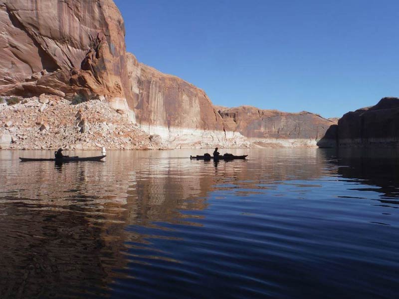
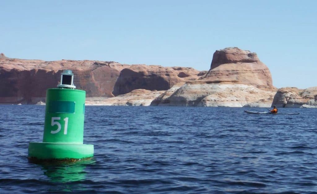
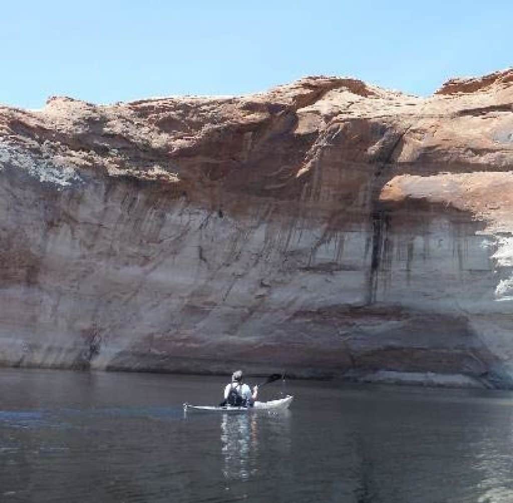
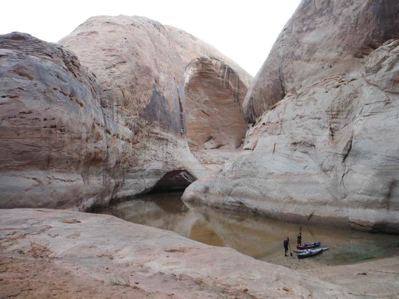
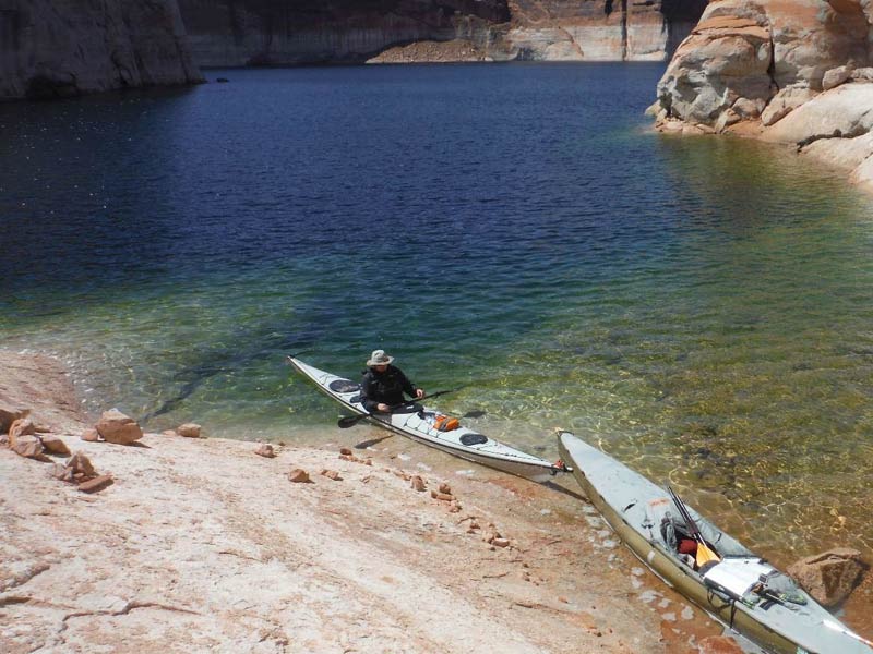
Lake Powell is marked with navigation buoys that delineate the distance from the Glen Canyon Dam in one mile increments. We started our trip at Halls Crossing which is 93 miles from the Glen Canyon Dam. A water taxi dropped us off at the entrance to Forbidding Canyon which is about mile 50. We paddled into the canyon and down the fork that leads to Rainbow Bridge National Monument. As we paddled a tour boat motored out and we experienced our first example of wave reflection off the narrow canyon walls. The first wave was sizeable but manageable. This wave bounced off the canyon walls and hit us again and again. These waves created an irregular chop that continued to harass us long after the tour boat had left.

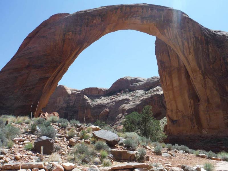
Rainbow Bridge National Monument was created in 1910 and it is managed by the National Park Service (NPS). It is only accessible by water or by an 18 mile hike through the Navajo Reservation. We tied up our boats at the floating dock and walked into the monument. The NPS interpretive ranger met us and answered our questions about the cultural and natural history of the arch. The arch is an important cultural site to the Navajo which is now visited by hundreds of tourists daily during the summer. There are literally thousands of cultural sites scattered across the 94 flooded canyons of Lake Powell. We were able to see a handful of the sites as we paddled and explored. Many of these sites have been abused; the NPS struggles with how to protect them.
We paddled out of the national monument and into the south fork of Forbidding Canyon also known as Aztec Creek to find our first campsite. The water level on Lake Powell is currently down over 100 feet. All of our maps and notes showed campsites at the end of Forbidding Canyon but they were now were 50 to 100 feet above us! We set up camp on a mud flat where the canyon creek flowed into Lake Powell. All night echoes bounced off the canyon walls every time a lump of clay slid off the mud flat into the water or a rock skidded down the cliff face.
Day 2 – April 15, 2017
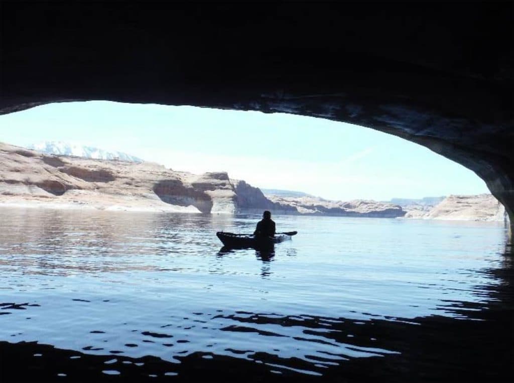
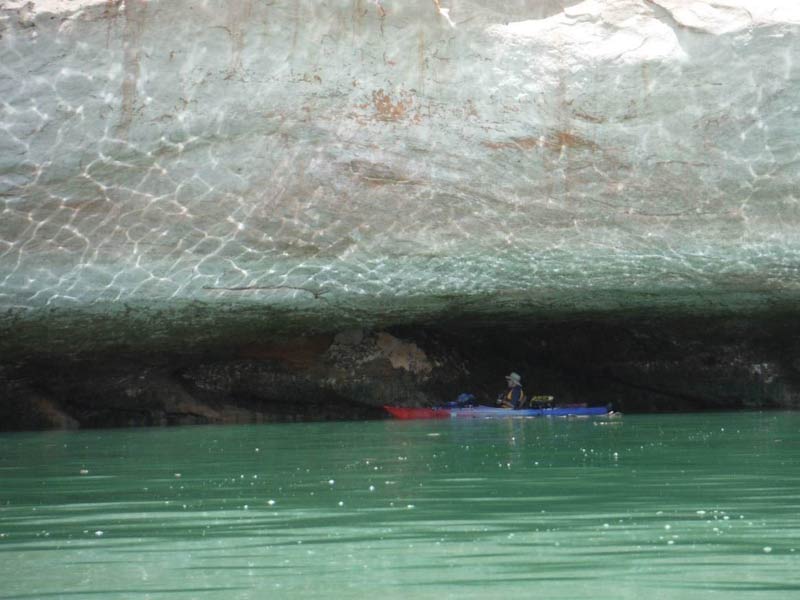
We paddled down Forbidding Canyon out into Lake Powell. It was about a 7 mile paddle onthe open waters of Lake Powell to the mouth of Cottonwood/Reflection Canyon. This was our first experience on this big lake and the scenery was impressive. We found several partially submerged caves which were especially fun to paddle into to escape the heat of the day.
We paddled up Cottonwood Canyon until we met the incoming stream. We landed on a sandbar that used to be under the lake; set up camp in a forest of dead cottonwoods between the canyon walls. Hiking up the canyon, we found the ruins of an ancient village perched high up on the cliff face. The NPS had posted signs to discourage climbing and we were happy to obey. The petroglyphs were located further up the canyon. The sun was disappearing behind the canyon walls so we gave up the search.
Day 3 – April 16, 2017
No one seemed to be in a hurry as we paddled slowly down Cottonwood Canyon and then up Reflection Canyon. The scenery was spectacular and we found more caves to explore. There was an 11 mile paddle on the Lake Powell to mouth of the Escalante River. On the way, we passed Llewellyn Gulch but choose to push on to the Escalante River. We stopped at the “Hole in the Rock” for lunch. This steep trail was a famous river crossing for the Mormon migration of 1879. Over 230 people with 80 wagons and livestock traveled down the vertical slot on the north side of the canyon, crossed the Colorado River and moved on to settle at Bluff, Utah.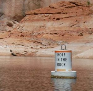
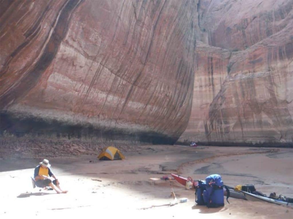
We continued on to the mouth of the Escalante River and up the river to Davis Gulch. The canyon walls cut off the sun early in the afternoon and we were running out of daylight. After a long day of paddling, we finally found a flat spot under a cliff pour off. (During the rare rain events, water will pour off the cliff edge and create an open spot at the base of the cliff.) We set up our tents on this open spot with the hope that it would not rain. We celebrated Easter Sunday by eating three chocolate Easter bunnies!
Day 4 – April 17, 2017
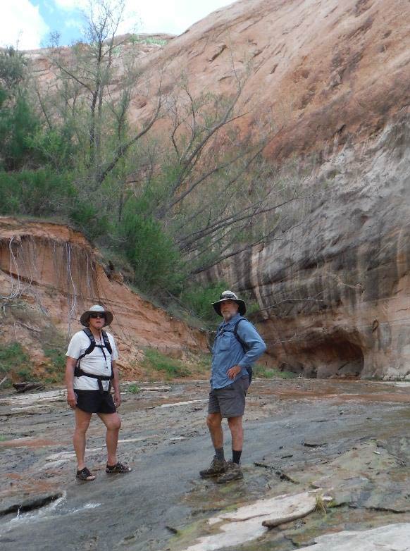
The next morning we continued up Davis Gulch in hopes of finding the La Gorce Arch. The arch, (which was only a few more twists and turns up the canyon), was hanging high above the current water level. At the end of the canyon, we found a huge alcove which would have been a great place to camp. Unfortunately, the alcove had been decorated with modern graffiti. A cultural ruin was suspended high on the cliff face above the alcove.
Davis Canyon was impressive. The canyon was a narrow, twisting path through vertical walls of Navajo sandstone. The lake ended at an impressive alcove at a bend in the canyon. The view from high up on the alcove provided an imposing glimpse of the canyon going both ways.
Paddling down Davis Canyon, we cork screwed our way back to the Escalante River. Turning north, we paddled by the Three Roof Ruins which are poised high above the current water level. This is a highly visible site has been impacted by too much visitation in the past. It is now inaccessible due to the lower lake level.
With great expectations, we made a wide turn to the east expecting to see the entrance to Explorer Canyon. Instead, our bows plowed into shallow water and our progress came to an end. We could see the entrance to Explorer Canyon but it was blocked by an extensive mud flat. This canyon is home to impressive petroglyphs and arches but was unapproachable at the current water levels.
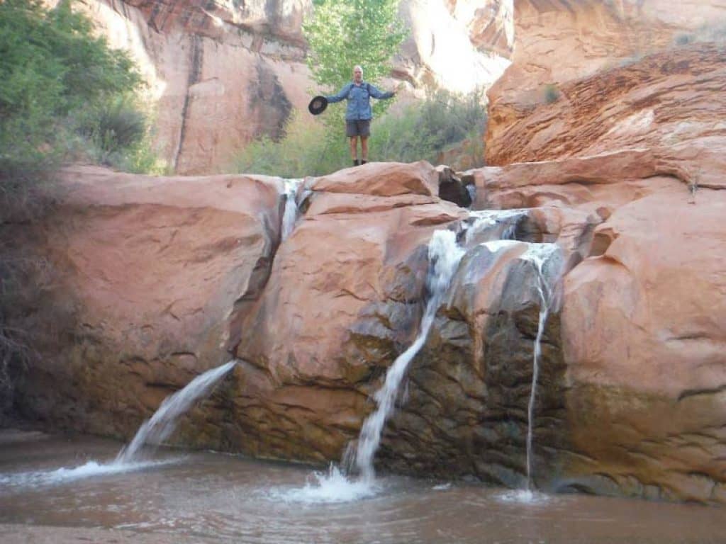
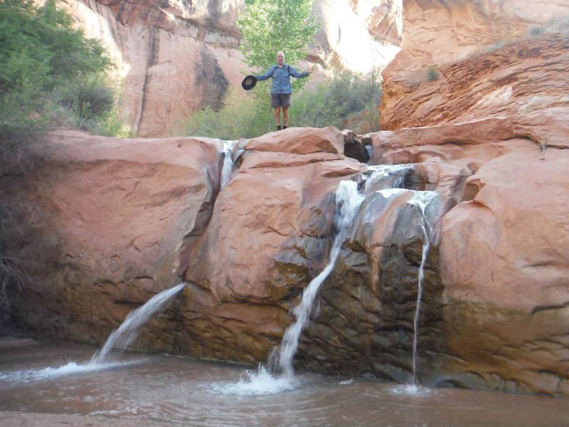
Paddling back down the Escalante River and up Willow Creek, we found another large alcove and set up camp. Hiking up the canyon, we discovered a notable little water fall but could not find the petroglyph I marked on my map. That night, we opened up our tents or slept on the ground to enjoy the night sky. The roof of the alcove and the canyon wall framed a million points of light. A great way to end the day!
Day 5 – April 18, 2017
Down Willow Creek and back into the Escalante River; we paddled to the confluence with the old Colorado River. We found a sand bar/campsite and stopped for lunch. As I unloaded the lunch barrel, I notice that the garbage bags were beginning to smell fro, the midday heat. We had been practicing “No Trace” camping. We had attempted to bag our human waste in “Biffy Bags” and to pack them out as required by the rules. The Biffy Bags were starting to produce a strong odor.
Of the three boats in our party, I was paddling the only canoe. The other two kayaks did not have enough room to carry garbage, so I had the honor of packing the garbage and the biffy bags in my canoe. The Park Service maintains a handful of floating toilets to reduce the flow of human waste into Lake Powell. I suggested that we stop at one near buoy #68.
The “pump station” was designed for motor boats and it was almost impossible to land a canoe. After demonstrating my gymnastic skills, I was able to board the pump station only to find that it did not accept garbage. The robust smell had become a strong motivating factor so I proceeded to dump each biffy bag into the sewage sink provided on the station. Struggling to not lose my lunch, I was successful in “flushing” our human waste into the holding tank.
I totally support the concept of packing human waste out of the desert. There are very few places where there is enough soil to properly compost waste. However, from the practical stand point, it is very difficult to do when paddling a small boat for several days. In hindsight I should have carried a separate bucket for the Biffy Bags.
The afternoon wind picked up and Lake Powell began to rock and roll as the waves reflected off the canyon walls to create a disturbing chop. I had been trying to do a self-video and had totally lost contact with the other two boats. Paddling solo through the violent chop was a sobering experience.
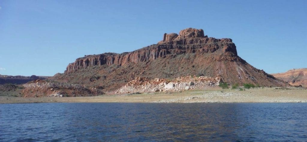
There was a 9 mile paddle from the mouth of the Escalante River to The Rincon and we arrived late in the afternoon. The Rincon is an ancient “ox-bow” of the old Colorado River and it is a very impressive feature on the lake. It was late and the wind was picking up so we tried to set up camp on the first sand bar we could find.
The wind got worse as we struggled to cook. We had picked an unprotected site and we were punished with gale force winds and biting sand. The food was “gritty” and it was almost impossible to set up the tents. Hank huddled between a rock and my canoe while Will curled up into a ball on the side of hill. I set up my tent and tried to sleep. I kept hoping that the poles would not break when the tent flattened out. Needless to say, it was a wild night on the shores of Lake Powell.
Day 6 – April 19, 2017
As the morning sun rose over the lake, we were greeted with another glorious day in the desert. Sometime during the wee hours of the night the wind had subsided and we actually got a little sleep. However, every nook and cranny of the tent and sleeping bag were filled with a fine later of sand. I dumped the grit out of the pans and tried to cook a breakfast before we headed back out on the big lake.
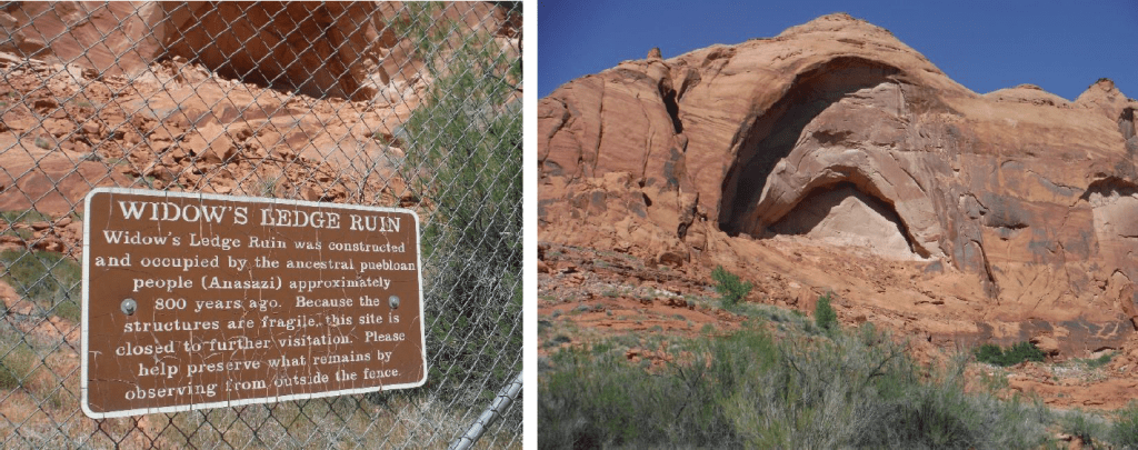
We chose to only paddle about five miles up to Slick Rock Canyon. We got there in the early afternoon and had time to set up, swim and explore. We took a long hike up the canyon to find the two cultural ruin sites. The first, Widows Ledge Ruin, was just above our campsite. The alcove was fenced off and closed to further visitation due to of overuse. We continued up the canyon and stumbled into a series of beaver dams which created a sequence of small wetlands filled with small fish! These wetlands were fed by small springs that seeped out of the canyon walls.
Looking up the canyon wall, we saw a fence that marked the boundaries of Mistake Alcove Ruins. Scrambling up the steep slopes, Hank and I finally got to the interpretive sign that explained the history of this ruin. It was the same sad story. The site had been trampled by too many visitors and the fence had been installed to protect the ruins. What was hard to comprehend, was that at the full pool level of 3700 feet, boats could almost motor up to this location. Now it is a serious hike to get back to this site. It was also hard to grasp that the people who lived in these cliff dwellings were able to grow crops in the canyon valley. A changing climate had ended that life style.
Slick Rock was a great campsite. It was protected from the wind and we had access to water for cooking and swimming. Everyone soaked in the lake and enjoyed the solitude of the desert. The only downside to this location was the pack raiding crows. Obviously lots of boats have visited this bay and trained the crows that good things can be found in bags. The crows got into our garbage sacks and stole Will’s zip lock bag of dried fruit.
Day 7 – April 20, 2017
Lake Canyon was our next to last stop on Lake Powell. It was about an eight mile paddle to get to the entrance of this canyon from Slick Rock Canyon. The bare vertical walls at the entrance were intimidating and were an indication that we might have trouble finding a spot to camp. Since we were within five miles of Halls Crossing we were seeing more motor boats. A couple of motor boats did pass us but they made every effort to throttle back and did not create a wake. After paddling up the wrong fork of the canyon, we finally arrived at the end of the Lake Canyon.
There was a nice flat terrace overlooking the end of the lake. Cattle had been grazing the site and the surface was pockmarked with hoof prints. It was too rough to pitch a tent. The only other flat site was a sand bar that was directly under the south canyon wall. We pitched our tents as best we could and went for a hike up the canyon.
There were several ruins, kivas and a waterfall on my map, but they were along way up the canyon. We followed the cow trail up the stream as far as time allowed. The cottonwoods and other shrubs had started to leaf out and the canyon looked green and lush. The songs of the canyon wrens were echoing off the walls as we head back to the campsite.
When we returned to the camp, the wind had picked up and was starting to roar down the canyon. I filmed dust clouds swirling across the end of the lake. I fixed the simplest meal possible and we ate while trying to find shelter against the canyon wall. I gave up on the idea of trying to wash dishes and packed everything in anticipation of another long night. The tent was “rock’n & roll’n” all night long. The only thing holding the tent down was my body weight. I swear the tent lifted up a couple of times.
Day 8 – April 21, 2017
When dawn broke I started to laugh uncontrollably when I saw how much sand had blown into the tent. I was lying in a sand box. There were piles of sand in every corner of the tent. I had sand in my hair, my eyes and even in the foot of the sleeping bag. The water in front of us was too muddy to filter for cooking. We gave up on the idea of fixing breakfast and broke camp. I could not load my canoe until I scooped out the sand. We stopped at the first flat spot we could find to filter some water and broke into the lunch barrel.
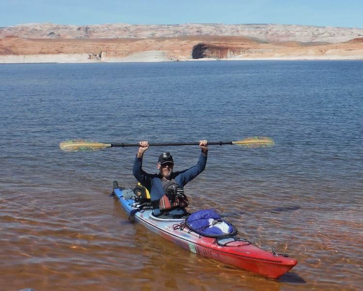
It was only a five mile paddle to Halls Crossing, but it was bitter-sweet. We did see a tandem canoe on the far side of Lake Powell paddling south. It was the only canoe or kayak we saw throughout our trip. Our time in the Red Rock Wilderness was coming to end but, I was not ready to leave this extraordinary landscape. Lake Powell offers a lot of water to paddle and canyons to hike. I hope to come back and soak up some more desert solitude.
PHOTO GALLERY:
Lake Powell Trip Report
Trip Dates: April 14 to April 20, 2017
Nearest City: Blanding, Utah
Put in: Halls Crossing, Utah
Take out: Halls Crossing, Utah
Water level: Low
Boats: Magic by Northstar Canoe, 16’ – Solo kevlar canoe
P&H Cetus MV, 17’7″ – Solo sea kayak
Necky Looksha Sport, 14’5’ – Solo kayak.
Paddlers: Hank Ostwald, Spencer, Iowa
Vern Fish, Waterloo, Iowa
Will Witt, Beaver Crossing, Nebraska
Difficulty: Intermediate – This trip requires wilderness camping, expedition canoeing skills and the willingness to paddle open water.
Submitted by: Vern Fish, vernfish@aol.com
Red Rock Wilderness
After reading Desert Solitaire by Edward Abby as young man, a visit to Southern Utah went to the top of my bucket list. In the late 1990’s I had the opportunity to backpack down several canyons in the Grand Staircase-Escalante National Monument and the Glen Canyon National Recreation Area (GCNA). I hiked down Hurricane Gulch and saw Stevens Arch on the Escalante River and actually walked into Lake Powell at the bottom of Fiftymile Creek.
Encompassing over 1.2 million acres Glen Canyon National Recreation Area (GCNA) stretches for hundreds of miles from Lees Ferry, Arizona north to Canyonlands National Park. It is a unit of the National Park Service which was created in 1972. It is bordered by several wilderness areas which are managed by the Bureau of Land Management and the Forest Service. The million+ acre Grand Staircase-Escalante National Monument is the largest wilderness unit. Collectively, the wild areas of Southern Utah are known as the Red Rock Wilderness.
Lake Powell
Having seen a small sliver of the Escalante River and Lake Powell, I was inspired to bring a canoe and paddle these waters. Lake Powell was created when the Glen Canyon Dam closed off the Colorado River 1963. It captures water from the Green, Colorado and San Juan Rivers. It runs the length of the GCNA and stretches for over 186 miles. At full capacity, the lake surface is 3,700 feet above sea level, 560 feet deep at the dam and covers an area of 161,390 acres. During our trip, the water level was down over 100 feet. The lake backs into 96 major side canyons and contains enough water to cover the entire state of Utah with six inches of water. Nearly 4 million people visit the lake primarily during the summer months. However, from October to April it is a large wilderness area with very few visitors.
Maps & References
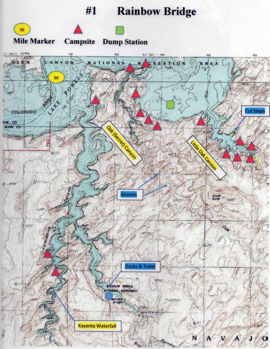
I used the National Geographic Trails Illustrated Topographic Map entitled Glen Canyon National Recreation Area as a planning map. This map can also be used as a primary navigation guide for the main channel and the numerous side canyons. To obtain details for the side canyons I pulled 1:24,000 USGS maps off the internet and included details from the book Boater’s Guide to Lake Powell by Michael Kelsey (ISBN# 978-0-944510-24-7). I have attached an example of one of the maps I created for the side canyons. Boater’s Guide to Lake Powell provides a wealth of information for anyone who wants to plan a trip to Lake Powell and hike up the side canyons. The following is the list of USGS maps we used for our trip:
Alcove Canyon Cathedral Canyon Davis Gulch Halls Crossing
Nasja Mesa Steven’s Canyon Rincon
Permits & Fees
There is a $25/week or $50 annual vehicle fee to enter the Glen Canyon National Recreation Area. There is no fee to camp outside the developed campgrounds.
Logistics
I meet Hank Ostwald in Des Moines, Iowa and drove to Beaver Crossing, Nebraska where we spent the first night at Will Witt’s house. We drove to Walsenburg, Colorado and spent the night at the Anchor Motel. On the way, we stopped at the Beecher Island Battleground in northwest Colorado. The next day we drove to Blanding, Utah and took Hwy 95 west to Hwy 276 which leads to Halls Crossing. Hwy 276 goes right through the new Bears Ears National Monument which was created in 2016. This is a spectacular drive through the desert, and yes you can see the ears of the bear as you drive through.
We camped at the Halls Crossing campground which is located across Lake Powell from Bullfrog Marina. Halls Crossing is connected to Bullfrog Marina by a ferry that may or may not be operational. The ferry was not running during our stay on Lake Powell. Bullfrog Marina provides a variety of services. Halls Crossing only had one small camp store that had just opened for the season. We had the campground to ourselves.
I had made arrangements with Aramark Concessions (435-684-3091) on Lake Powell to provide water taxi service from Halls Crossing to Rainbow Bridge National Monument. This three hour ride took us south on Lake Powell and cost $802 for the three off us. (Bring ear plugs for the taxi ride.) We spent the next week paddling north to Halls Crossing. We stopped at Moab, Utah on our way back to Beaver Crossing, Nebraska.
Overview
We used the main channel of Lake Powell has a route between side canyons. Our itinerary included the following stops:
Day 1 Forbidding Canyon
Day 2 Cottonwood Canyon/Reflection Canyon
Day 3 Davis Canyon (Escalante River)
Day 4 Willow Canyon (Escalante River)
Day 5 Rincon (Lake Powell)
Day 6 Slick Rock Canyon
Day 7 Lake Canyon
After the water taxi dropped us off at the mouth of Forbidding Canyon, we paddled into the canyon and down the fork that leads to Rainbow Bridge National Monument. As we paddled in, a tour boat motored out and we got to experience our first example of wave reflection off the narrow canyon walls. The first wave off the tour boat was sizeable but manageable. This wave bounced off the canyon walls and hit us again and again. These waves created an irregular chop that continued to harass us long after the tour boat had left.
In addition to reflection waves, we also learned to respect the wind on Lake Powell. The mornings were cool and calm. As the air heated up during the day, the winded picks up and can become a gale force by mid-afternoon. The wind picks up loose sand and creates a mini sand storm. If you stay on the water, you must deal with wind and reflection waves. If you try to camp on an exposed beach or a rock outcrop, you will be pelted by sand and powerful wind gusts. We made the mistake of trying to camp on an open beach at Rincon and were punished by wind and sand. It was almost impossible to cook or set up a tent. We had the same experience in Lake Canyon even though we were tucked under a steep cliff deep in the canyon.
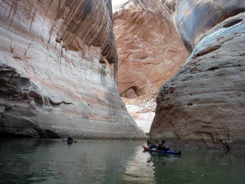
The water is very clear, you can look deep into the lake. As a result, you lose your perception of time and space. A couple of times I felt like I was flying instead of paddling and almost fell out of my canoe. The deep water was a dark blue, but shallow water became an emerald green. The contrast was dramatic. Light reflecting off the waves created a dazzling light show on the light colored sandstone canyon walls and in the caves.
In April the water is cold, very cold! Swimming was limited. Swamping a canoe could be life threating because the vertical canyon walls do not provide any place to get out of the water. It was hard to find a place to stop for lunch or to just get out of the boat to stretch your legs. There are very few beaches or flat rocks. Paddling in the main channel was intimidating due to the vertical canyon walls which went on for miles and provided no place to get off the water. John Wesley Powell who paddled the Colorado River in 1869 described what we saw, “the walls rise from the water’s edge, so that we cannot land.”
The water level in Lake Powell is down almost 100 feet from the full pool level of 3700. We could see the “bath tub” ring from the high water mark on the vertical canyon walls. This low level allowed us to see caves and arches that had been flooded for decades. The bad news was: all of the guide book information was out of date. The Boaters Guide to Lake Powell listed campsites that were now 50 to 100 feet above the current water level and inaccessible to us. It also meant that we had to hike into cultural sites and geologic formations that used to be on the water’s edge. This was particularly frustrating when we tried to paddle up the Escalante River to Explorer Canyon. This canyon hosts several outstanding cultural and geologic features that were now blocked by a mud flat.
The night sky was simply outstanding. There is no light pollution in southern Utah and clouds were a rarity. In the dry desert air the night sky was filled with stars and constellations that are impossible to see near urban areas. Because there were no bugs and no threat of rain we did not always use our tents. In Willow Canyon, we camped in a huge alcove that created an oval shape window into the night sky. The last thing I can remember before I fell asleep was seeing countless points of light outlined by the canyon walls.
In John Wesley Powell’s trip report he noted, “We glide along through a strange, weird, grand region… a curious ensemble of wonderful features – carved walls, royal arches, glens. alcove gulches, mounds and monuments….we decided to call it Glen Canyon.” The landscape is extraordinary. Powell’s quote from 1869 described our experience, “we glide hour after hour, stopping now and then, as our attention is arrested by some new wonder. I have attached photos that attempt to capture the stunning beauty of this flooded river valley.
On another note, this spectaular landscape also created problems for camping. As Powell noted, “the landscape everywhere, away from the river, is of rock-cliffs of rock, tables of rock, plateaus of rock, terraces of rock, crags of rock….rocks everywhere, and no vegetation.” It was very hard to find a place to camp. At least once 4
we chose to camp underneath a cliff pour-off because it was smooth and kind of flat. If it had started to rain somewhere in the watershed, our campsite could have been washed away!
Highlights & Observations
The landscape is unrivaled and extraordinary. The interplay of bare rock, clear water, cobalt skies, dry air and continuous sunlight is magical. Every time we pulled into a new canyon there as an air expectation. What will we see around next bend? The only time I was disappointed was when the Escalante River bottomed out and we could not paddle up to Explorer Canyon to see its secrets.
The wind and sand storms were frustrating. In retrospect we should have started sooner and made more of an effort to find a protected location to set up camp earlier in the day. Camping sites were limited and more than once we had to make do with a less than ideal location. The low water levels provided access to caves and cultural sites that are usually flooded. However, it took longer to hike upstream to see these sites.
Almost all of Lake Powell is accessible by motor boats, from the far north and the south. However, the Escalante Canyon is a long way from the big marinas and we did not see many motor boats. In April, there are not that many boats on the water and the lake is so big that the boats just become a wave in the distance. Lake Powell is surrounded by huge wilderness areas. A short hike up a canyon separates you from the motorized traffic. Most of the time, we had the canyons to ourselves.
In April, the temperature and weather was perfect for paddling. If you are willing to paddle on big open water, Lake Powell is a great place to escape the icy grip of a Midwest winter and start the paddling season.


Beautiful part of the world. Some awesome photos you shared.
Looks like a blast! I still need to take my kayak down to Lake Powell. I’ve lived in Arizona/Utah my whole life and still haven’t been to Lake Powell lol, sad.