

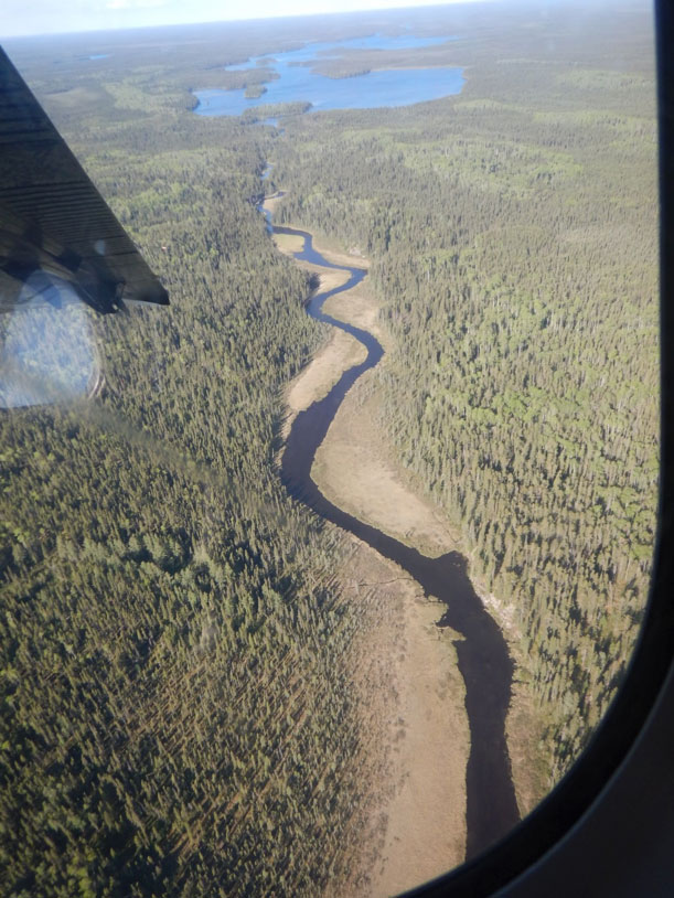
The Greenmantle River just below Greenmantle Lake and the first portage (Photo: Ray Tallent)
Trip Log
June 18 – 28, 2019
Submitted by: Vern Fish, 3488 Kingswood Place, Waterloo, Iowa 50701, vernfish@aol.com. See the attached file Table of Features for the GPS coordinates.
Day 1 – June 18, 2019 (Warm and sunny)
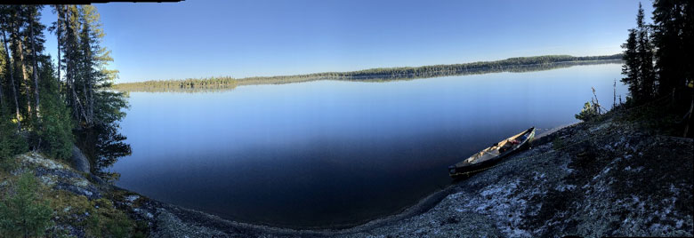
Our float plane landed on the west end Greenmantle Lake after a short flight from Mattice Lake. The landing site was near an old dock and “abandoned” hunting camp. There were three boats, a collapsed shack and an outhouse. There were lichens growing on the boats so the site had not been used for a long time.
Paddling out of the southwest corner of the lake we went a short ways upstream towards the headwaters and the height of land. I think we could have portaged into the Ogoki River watershed if we had keep going. Several swans and lots of waterfowl met us on our way upstream.
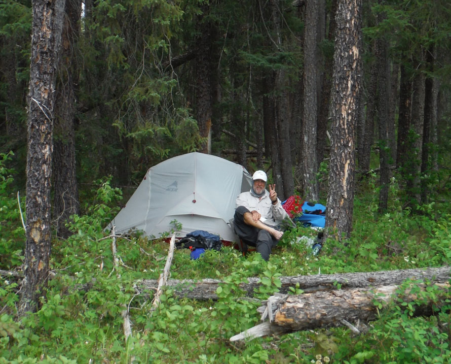
On the way back across Greenmantle Lake we found three potential campsites. We camped on the third site (Camp 1) on an island near the portage out of Greenmantle Lake. A moose and calf crossed the lake near our exit point. All together we found four campsites and 5 cached (abandoned) boats. There appears to be a long history people camping on Greenmantle Lake.
Day 2 – June 19, 2019 (Warm and sunny)
The crew paddled short distance down to the exit point and found a portage on river left. While crossing and clearing the route we found a blaze on a tree and a faded tattered strip of survey tape. The portage had not been maintained but it appears there was a history of use.
Hank Ostwald “portaging” out of Greenmantle Lake, “a log and rock choked stream”. (Photo: Vern Fish)
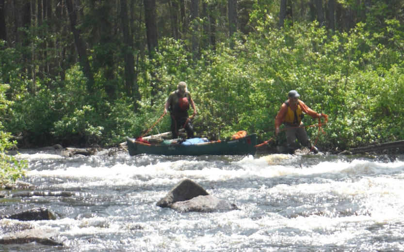
The portage (P1) was broken into three separate segments (A, B & C) separated by a log and rock choked stream. The total distance for all three segments was 492 meters. The first segment, A, was about 170 steps with 44 log step overs. Segment B was shorter with only 11 step overs. Hank and I lined and carried the loaded canoe over down logs and rocks to avoided Segment C. Dan and Ray actually portaged on river left. The fourth and final barrier was a beaver dam which both crews carried over. All together it took about 3 hours to get the boats back into the river.
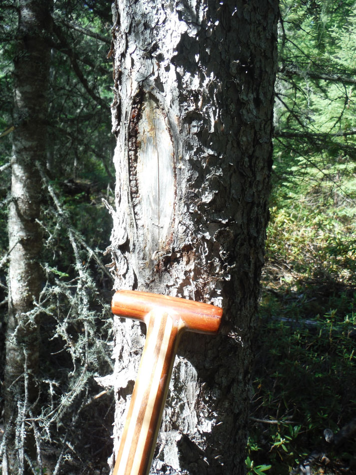
Portage blaze on Greenmantle Lake Portage (photo: Vern Fish)
The river was wide but shallow, slow and very winding until it abruptly constricted. This “topographic change” can be seen on the topographic maps. At this point the river became very narrow. At places the river was less than one canoe length wide. Coming around a corner Dan and Ray meet a black bear standing in the water. We also met a couple of moose before finding a campsite. We were forced to work our way out of the wetland and up to higher ground to find a dry spot to camp. It was not a great campsite (Camp 2).
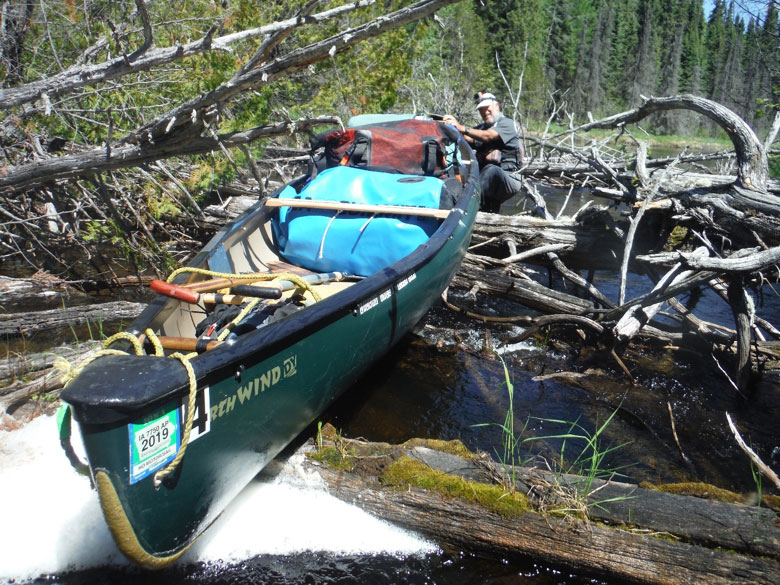
Hank Ostwald (foreground), Ray Tallent & Dan Otto (background) portage over a beaver dam downstream from Greenmantle Lake (photo: Vern Fish)
Campsite on Greenmantle Lake (photo: Hank Ostwald)
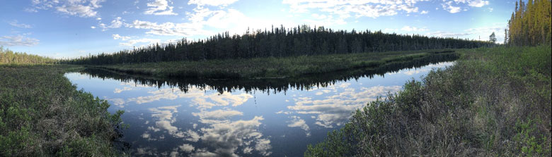
The Greenmantle River as it flows through its buffer of wetlands (photo: Hank Ostwald)
Day 3 – June 20, 2019 (warm and sunny)
On the water by 9:30 and into the first SLW (Shoot, Line or Wade). There was not enough water to run this little rapid so both canoes were lined. The first bluff went by on river left. This little bluff was big enough that it can be seen on Google Maps. There might have been a place to camp on the top of this and other little bluffs we passed but we did not stop to explore.
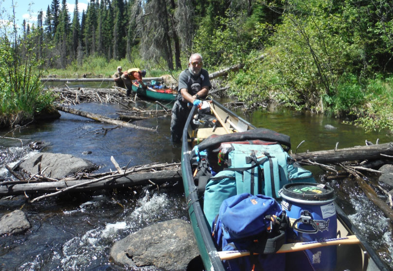
Ran into a log choked segment of the river and decided to drag the canoes around the log jam on river left (P2). Everyone got a stick in the face or poked in the arm while trying to find a path along the shore line. Our short portage ended just upstream from SLW #2 which was too shallow to run and required that the boats be lined.
The river now flowed and twisted its way through a lush wetland that was ideal moose habitat. There were moose standing in the river or leaning over the bank around almost every bend in the river. Altogether both crews saw at least 8 moose before entering Suzanne Lake. Log jams forced both crews to climb over or cut through several log jams. As Suzanne Lake approached the logs blocking the river showed saw cuts where someone had tried to keep the river open. It was my guess that moose hunters coming upstream from Suzanne Lake were making these cuts.
The river got wider just before the canoes floated into a sandy delta that mark our entrance into Suzanne Lake. There were no campsites to be found on Suzanne Lake until we reached the far NE corner of the lake. Another “abandoned” hunting camp appeared on lake right. This site can be seen on Google Map. The site (Camp 3) offered a crude table, a lean-to, four boats, a lot of old gear and room for four tents! This was a great spot to camp!
Don Elliot, our outfitter, was getting daily updates on our progress from our satellite phone. After reaching Suzanne Lake the following message came from Don:
“You are the first that I know of that have paddled that section of the Greenmantle. Congratulations, making it to Suzanne Lake. You should have now completed the most difficult portion of your trip.” Jun 20, 2019 7:30 PM.
Day 4 – June 21, 2019 (warm and sunny)
This was a layover day (Camp 4). The cook got up late and fixed pancakes before both crews paddled down to the rapid that marked the end of the lake. There was a well-traveled portage (P3) on river left with a cached boat at the downstream end. The rapid (SLW #3) was a CII that twisted to right before plunging hard left down a short series of Vs to a pool below. This is the only other major portage along the Greenmantle.
Ray and Dan start fishing the pool at the bottom while I casted into the pool at the top. A Brook Trout came up to meet my lure and with a little luck and very little skill I caught my first Brook Trout, ever! I only kept two fish but I got to see several others. Ray and Dan brought in three nice walleye. Supper included biscuits, coleslaw, hash browns and with a mix of walleye and trout.
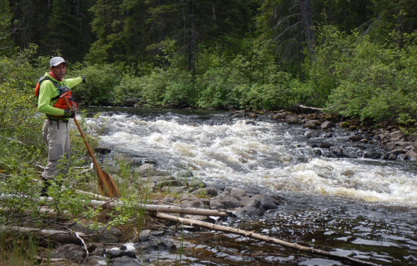
Vern Fish at #5 SLW (Shoot, Line or Wade) on the Greeenmantle River (photo: Ray Tallent)
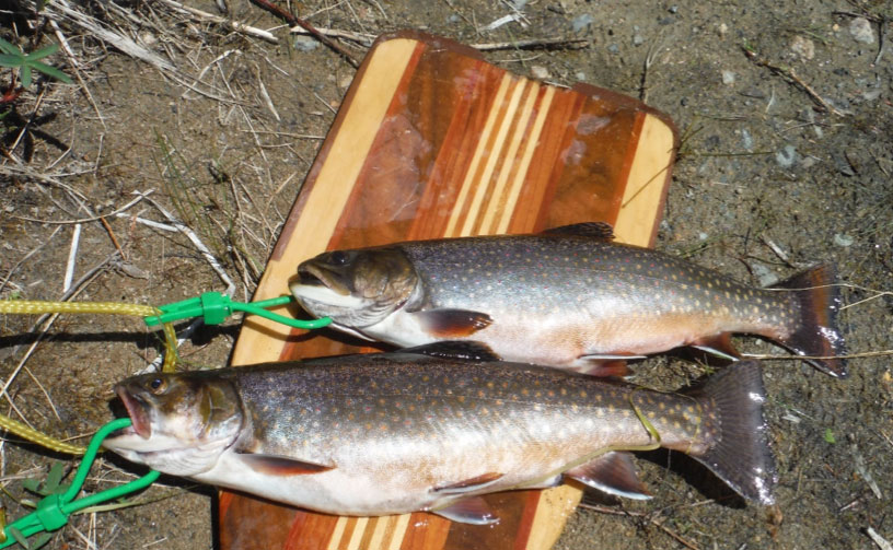
Brook Trout on Suzanne Lake, Greenmantle River. (photo: Vern Fish)
Day 5 – June 22, 2019 (warm and sunny)
We used the portage (P3) on lake left to exit Suzanne Lake. A short distance downstream we came to a small rapid that I had not found on my Google Map search (SLW #4). SLW #5 was nice little drop followed by a small eddy pool and beach. Ray caught a nice walleye while we eat lunch.
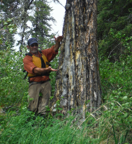
Dan Otto standing by the blaze marking the portage to the Misehkow River (photo: Vern Fish)
Dan found the large pine with a big blaze that marked the portage into the Misenkow River on river left. The portage has disappeared into the forest but the landing looked like it had been used as a campsite(s) in the past. As I explored the site I could see ax marks on other trees. At some point in time this had been an active route in and out of the Greenmantle. The site had a sense of history.
The crews ran the upper two drops on SWL #6, which included a tricky CI, and stopped for the day. There was enough flat ground on river right to set up Camp 5. There was no evidence of people. The sunlight drifted down through tall vertical pines while the sound of running water echoed in the background. The forest that surrounded our camp was magical. This is why I search out and travel through wilderness. For me it was a signature moment for the trip.
Day 6 – June 23, 2019 (Warm and Sunny)
Ran the lower two drops on SWL #6 almost immediately after leaving Camp 5. SLW 7, 8, 9, 10, 11 and 12 came and went without causing any issues. There were lots of down trees separated by flowing water between the heavily forested banks. It was a very pleasant paddle when not pulling the canoes over logs or cutting branches. The drops were an enjoyable diversion from the continuous line of old forest. Stopped between SLW #9 and #10 to take lunch.
Ray Tallent and Dan Otto lining down a rapid on the lower Greenmantle River. (photo: Vern Fish)
Just upstream from Camp 6 Dan saw an old metal bucket jammed over a tree stump. Nobody stopped to explore the site but it was an indication that we were getting close to the confluence. Right on cue the Shabuskwia River rolled in on river right. Both boats pulled out on river right at the open spot that over looked the confluence. The site had a grassy fire ring and enough space for four tents and the Cooke Tundra Tarp. This was the same site that Hank and I had lined up to from Patte Lake in 2016. We had come full circle.
Day 7 – June 24, 2019 (Cold and wet)
During the night the temperature dropped and it started to rain. It was still raining at daybreak and it continued to rain all day. This would be our second layover day. Everyone got up late and the cook made pancakes. Ray started a fire in the light rain and made two batches of biscuits. It was too cold and wet to travel so we ate, told stories, listen to rapids and enjoy the isolation of this remote campsite (Camp 7).
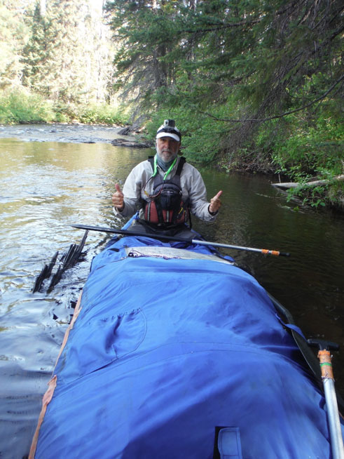
Hank Ostwald, another successful run on the lower Greenmantle River (photo: Vern Fish)
Day 8 – June 25, 2019 (Cool, cloudy with light rain)
The Greenmantle now disappears into the Shabuskwia River. The boats entered SLW #13 almost immediately after leaving camp. This CI was followed by a more challenging CII (SLW #14) that twisted around the next bend. SLW #15 was a CI and final run on this set of three. This set wrapped around a bend in the river and was a good warm up for what was to follow.
The next set of three SLW’s (15, 16, and 17) offered a CII to a CIII challenge. These runs were very hard to scout and the only option was creep up, take a quick look and go. Dan and Ray were the lighter boat and they cut their way through this maize of whitewater with no problems. Hank and Vern grounded out on the last tight turn. Hank weights almost 190 pounds. Vern might have cleared the last rock with a smaller bowman!
After SLW #18 the river slows down and starts to meander. In the distance the Shabuskwia Hills slowly emerge on river left. This highland is not named on any map but they do stand out above the surrounding wetlands and Patte Lake. We took lunch on a sandy beach on Patte Lake and struggled to stay warm. It was still very cool and wet and I was borderline hypothermic.
Exiting Patte Lake the Shabuskwia River joins the much bigger Albany River. Our speed pickup as this big river pushed us down the Upper Eskakwa Falls. The portage (P4) is on river right and it led to a very nice and well used campsite (Camp 8) that overlooked the falls. I took a nap and starting hearing voices. The other guys also reported similar experiences. The pounding water creates low frequency harmonics and the water fall is responsible for creating a positive electric field. This site is also reported to be near a traditional burial site. All this appears to have an impact on the mind of a physically tire paddler.
Camp at the confluence of the Greenmantle and Shabuskwia River, Hank Ostwald. (photo: Vern Fish)
Day 9 – June 26, 2019 (Cloudy)
Back on the mighty Albany River for a short run down to the Lower Eskakwa Falls. The portage (P5) is a well-marked trail on river left that avoids the gorge. In 2010 I enjoyed a trip down the Albany River and now I was reliving those positive memories.
The next portage on river left (P6) follow a trail that provided a great view of Snake Falls. Nine years ago I enjoyed the opportunity to run Snake Falls. Now Hank and I took a hard look at a big pushy river being forced through a tight gorge and over a ledge that creates a visible hydraulic. Being much older and wiser I recommended that we enjoy the view and then carry the canoe.
Downstream we found a well-marked campsite (Camp 9) high up on the shore on river left. Several mature trees had been marked with ax blazes and site was obviously used as a hunting camp. I rigged a rope to help with the climb up from river and we settled in for the night. The sky open up and the sunlight poured in to create a dry sunny end to our day on the Albany.
Day 10 – June 27, 2019 (Warm and sunny with a west wind)
The crew was up and on the water by 8:33. Stopped to take a short break on the sand point that marks the entrance to Howells Lake. This could be an emergency campsite if the need arose. The spray skirts were strapped down in preparation for a 3 mile open water crossing of Miminiska Lake. With a strong tail wind the boats were pushed across this opening in less than hour. The waves were growing as we round a point that finally blocked the wind.
The crew landed at a rocky point at 12:15 across the bay from the Chapel of St. Andrew, the Little White Church. This point is shore lunch site for the fishing camp on Curry Bay. It had a picnic table and room for four tents. This was a well-worn site (Camp 10).
Day 11 – June 28, 2019 (Warm and sunny)
No big hurry today, the take out point is just across the bay. Paddled across and landed at the sandy beach. This beach is a good place for a float plane to land and load.
Nine years ago I also stopped to explore this little church. Not much had changed in the past decade. The Chapel of St. Andrew, was dedicated in 1984 and serves a far flung Catholic congregation that includes the Fort Hope First Nation Reserve and pass through paddlers. The register listed people who were goose hunting, fishing and moose hunting. We signed in and joined the parade of people who had visited this remote little church. At about noon our pilot landed his float plane on the beach in front of the little white church.
Wild & Remote
With the gear loaded our plane flew us down the east side of the Wabakimi Wilderness Complex on its way back to Armstrong. There was a sharp line between the land protected as wilderness and the Crown Lands that were open to logging. There were logging roads, log piles and slash heaps outside of the park. Wabakimi Provincial Park is big but it is still an island of green surrounded by human impacts.
The Greenmantle River is a special place within the Wabakimi Complex. The entire watershed is protected within a designated as wilderness area. It is not recognized as canoe route in Wabakimi Provincial Park and the route is not maintained. Consequently, this river is truly “wild and remote”. The unbroken boreal forest is magical. A paddler should enter this watershed at his/her own risk and respect the wild character it offers.
Greenmantle River Wabakimi Provincial Park Trip Report (pdf)
Table of Features (pdf)


These reports are great for helping to guide the selection of group members for various routes. Some people crave adverse conditions while others avoid them! A trip to Wabakimi is on our calendar for summer 2020.