Canoe Route: Seagull Lake, Boundary Waters Canoe Area Wilderness
When a wildfire rolls through the forest patchwork of the Boundary Waters Canoe Area Wilderness – red and white pine, jack pine, spruce, birch and aspen – canoeists lament the loss and alteration of the familiar landscape. But most tree stands within the BWCAW actually originated out of wildfire (see this article). With a little bit of knowledge and an understanding of what to look for, it’s possible for a recreational canoeist to read this fire history as they paddle through the BWCAW.
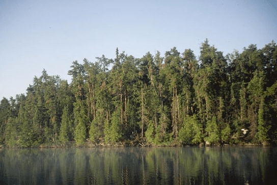
Seagull Lake photo by Lee Frelich.
According to Dr. Lee Frelich, Director of the University of Minnesota Center for Hardwood Ecology, a few simple characteristics reveal a lot about a forest’s history. For example, a recently burned area is dominated by sun loving plants and small seedlings that create a bright green landscape. Depending on the intensity of the fire, this green might be interspersed with the pink of exposed granite bedrock.
Older, medium-aged forests take on a darker hue as trees mature. Moss grows 4 – 6” thick and covers 80 – 90% of the forest floor. The tree makeup is limited to a small number of species, and trees tend to be similar in age and size. This creates an even, uniform texture when viewed from across a lake. In contrast, an old forest appears rough because more tree species of varying color and size have grown in over time. In these forests moss can grow up to a foot in depth and covers the entire forest floor.
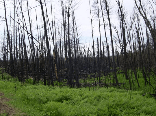
The BWCAW greens up after a fire. Photo by Tim Eaton.
With just a short trip out of Seagull Lake and some of Frelich’s insider tips, canoeists can learn to read these characteristics first hand. In a single weekend, it’s possible to see forests in nearly every stage of regeneration – from the recent and highly publicized burn left by the 2007 Ham Lake Fire to a red pine forest undisturbed for 300 years. Naturalists at heart and even paddlers simply curious about the aftermath of the Ham Lake Fire will gain a true perspective for the role wildfire plays in shaping the landscape.
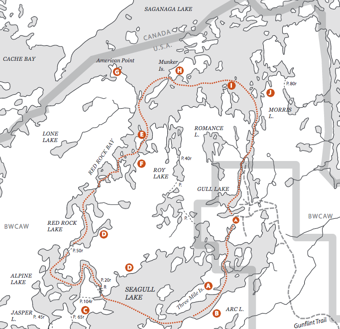
Route: Seagull Lake – Alpine Lake – Red Rock Lake – Saganaga Lake – Seagull River – Gull Lake
Skill Level: Easy to Moderate
Type: Loop
Length: 18 Miles
Put In/Take Out: Trail’s End Campground (3/4 mile past County Road 11); a free parking lot provides access to Seagull lake to the south and Gull lake to the north.
Potential Difficulties: Be prepared for potential high winds on Saganaga Lake. In addition, plan to travel with a map and compass to navigate the many islands.
Portages: 4 (easy to moderate)
Camping After the Fire: The Seagull Lake area is open and safe for canoe travel. The Forest Service has reopened nearly all campsites in the area.
Permit Info: Permit required.
Permit Entry Point: #54 Seagull Lake
Additional Information: Camping is available at Trail’s End Campground for the night before or after your trip.
Additional Resources: Boundary Waters Canoe Area, Volume 2 Eastern Region
For information on outfitters and places to stay on the Gunflint Trail, see: Grand Marais Destination Guide.
Route Highlights:
Seagull Lake
Witness to multiple fires over the last decade, Seagull Lake affords paddlers views of several young forests:
![]() A 2002 prescribed burn on Three Mile Island cleared the way for the birch now growing in by consuming the jack pine felled by the 1999 blow down
A 2002 prescribed burn on Three Mile Island cleared the way for the birch now growing in by consuming the jack pine felled by the 1999 blow down
![]() The 2007 Ham Lake fire burned the southeastern shore of Seagull Lake, directly across from Three Mile Island
The 2007 Ham Lake fire burned the southeastern shore of Seagull Lake, directly across from Three Mile Island
![]() The Cavity Lake Fire burned the southwestern shore of the lake in 2006. This fire burned hotter and with more intensity than the Ham Lake fire. Look for more exposed bedrock and possibly slower regeneration
The Cavity Lake Fire burned the southwestern shore of the lake in 2006. This fire burned hotter and with more intensity than the Ham Lake fire. Look for more exposed bedrock and possibly slower regeneration
![]() The northwestern shore of Seagull burned in 2005 during the Alpine Lake Fire, which burned the strip of land between Seagull, Alpine and Red Rock Lakes
The northwestern shore of Seagull burned in 2005 during the Alpine Lake Fire, which burned the strip of land between Seagull, Alpine and Red Rock Lakes
Saganaga Lake
In contrast to the recently disturbed Seagull Lake, Saganaga is home to medium-aged and old forests.
As you first enter Saganaga, look to Bear Island for a 100-year old, even aged forest of red pine and black spruce.
![]() The Roy Lake Fire of 1976 burned the eastern shore of Red Rock Bay. It’s now home to a young forest of birch and alder. A nameless island that also burned is dense with jack pine, black spruce, aspen and birch, and moss is just beginning to grow in
The Roy Lake Fire of 1976 burned the eastern shore of Red Rock Bay. It’s now home to a young forest of birch and alder. A nameless island that also burned is dense with jack pine, black spruce, aspen and birch, and moss is just beginning to grow in
![]() Visit American Point to see a forest that has not burned since 1801
Visit American Point to see a forest that has not burned since 1801
![]() Munker Island has remained undisturbed since the 1700s. You’ll find a 300-year-old red pine forest that is 90 feet tall. The under story features 40-foot white cedar, foot-deep moss and tons of coarse wood debris that has accumulated in the absence of fire
Munker Island has remained undisturbed since the 1700s. You’ll find a 300-year-old red pine forest that is 90 feet tall. The under story features 40-foot white cedar, foot-deep moss and tons of coarse wood debris that has accumulated in the absence of fire
![]() As you head toward the Sag Corridor, look for a nameless island 100 feet high that looks like a big lump of pink granite. It burned during the 1995 Sag Corridor/Romance Lake fire of 1995. Young jack pine and black spruce are just starting to take hold
As you head toward the Sag Corridor, look for a nameless island 100 feet high that looks like a big lump of pink granite. It burned during the 1995 Sag Corridor/Romance Lake fire of 1995. Young jack pine and black spruce are just starting to take hold
 Sag Corridor/Seagull River
Watch for a patch of forest that burned in the Sag Corridor Fire of 1995, but most of this stretch remains undisturbed since 1801.
Download This Recommended Canoe Route PDF
Read More about The Aftermath of Fire: Regeneration after the Cavity Lake and Ham Lake Fires >
Canoeing.com route reports are intended for inspiration only. We do our best to include accurate and helpful information, but they are not intended to be complete trip planning guides. Wilderness travel and canoeing are inherently risky activities and environmental conditions are always changing. It is important to exercise judgment and due diligence by selecting routes appropriate for your skill level, and gather additional information. Do not rely solely on the information found here, all risk and liabilities are yours alone.